Powerful Weekend Storm to Soak the South With Heavy Rain and Severe Threat Before Possible Northeast Snow Development
ATLANTA, GEORGIA — A dynamic and potentially high-impact weekend storm system is taking shape across the United States, with forecast guidance showing a major rainmaker for the South from Friday through Sunday, followed by a possible winter weather scenario in the Northeast. While model disagreement continues in some aspects of the track and phasing, confidence is growing that this will be a widespread and impactful system.
The southern half of the country appears poised for multiple rounds of heavy rain and thunderstorms, while farther north, colder air interactions could introduce a snow component depending on how the system evolves.
Heavy Rain and Severe Weather Risk Across the South
Forecast maps show a strengthening low pressure system organizing over Texas and the Lower Mississippi Valley before lifting northeast. As the system advances, deep Gulf moisture is drawn northward into Louisiana, Mississippi, Alabama, Georgia, and Florida.
The precipitation panels indicate a broad shield of rain with embedded stronger storms stretching from eastern Texas through the Southeast. Wind fields and atmospheric parameters suggest enough overlapping thermodynamics and kinematics to support at least a slight risk (Level 2 of 5) for severe weather during parts of the event.
The severe risk is expected to begin in the western portions of the South on Friday, then shift eastward through Saturday and Sunday. While a widespread severe outbreak does not appear likely at this time, isolated damaging wind gusts and a few stronger storms cannot be ruled out within the corridor of enhanced instability.
In addition to thunderstorms, heavy rainfall could lead to localized flooding concerns in areas where storms train over the same regions.
Storm Structure Suggests a Dynamic Setup
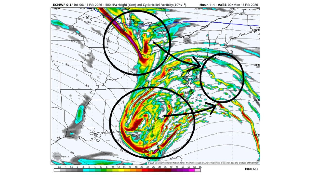
Upper-level analysis imagery highlights a pronounced trough digging into the southern United States, with strong cyclonic vorticity and jet energy interacting with surface features.
If northern stream energy phases with the main southern stream system, the storm could intensify more rapidly as it lifts toward the Mid-Atlantic and Northeast. This phasing scenario remains one of the key uncertainties in the forecast.
Such a setup is often described as “dynamic” because small shifts in timing or interaction between atmospheric branches can significantly alter outcomes — including where the heaviest rain falls and where colder air is drawn into the system.
Potential Winter Weather for the Northeast
While the South deals primarily with rain and thunderstorms, parts of the Northeast could see a different outcome depending on how the storm evolves.
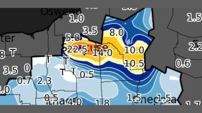
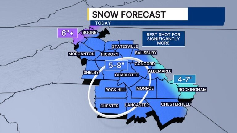
Ensemble snowfall projections show measurable accumulation across portions of Pennsylvania, New York, Connecticut, Massachusetts, Vermont, New Hampshire, and Maine. Higher totals appear possible in interior New England and northern zones where colder air may hold firm.
If the storm deepens slightly farther north, a low pressure center could strengthen enough to inject colder air into the backside of the system. That scenario would allow snow to develop across parts of the interior Northeast while coastal areas see a rain-to-snow transition or remain mostly rain.
It is important to note that this winter weather scenario is more conditional than the Southern rain threat and depends heavily on storm phasing and track.
What Happens Next?
This storm is unfolding right in front of us, and details will sharpen as we move closer to the weekend. The highest confidence impacts at this time include:
- Heavy rain across the South from Texas to Georgia
- A corridor of severe weather potential Friday through Sunday
- A possible winter weather component for parts of the Northeast
Model differences remain, particularly regarding how much northern stream energy interacts with the main storm. That interaction will ultimately determine the strength of the system as it moves north and whether snow totals in the Northeast increase.
Residents across the Southern United States should prepare for a wet and occasionally stormy weekend, while those in the Northeast should monitor updates regarding potential snow development.
For continued updates on major weather systems affecting travel, events, and live music plans nationwide, stay connected with ChicagoMusicGuide.com for the latest coverage.