Pennsylvania Set for Spring-Like Thaw February 17–21 as Temperatures Climb Into the 50s Before Colder Pattern Returns
HARRISBURG, PENNSYLVANIA — After a stretch of deep winter chill, Pennsylvania is preparing for its first meaningful spring-like thaw of the season, with forecast guidance highlighting above-average temperatures from February 17 through February 21. The Climate Prediction Center outlook shows the region leaning solidly toward warmer-than-normal conditions during that window.
While winter is far from officially over, this period could offer several days of noticeably milder air across much of the state.
February 17–21 Trending Above Average Across Pennsylvania
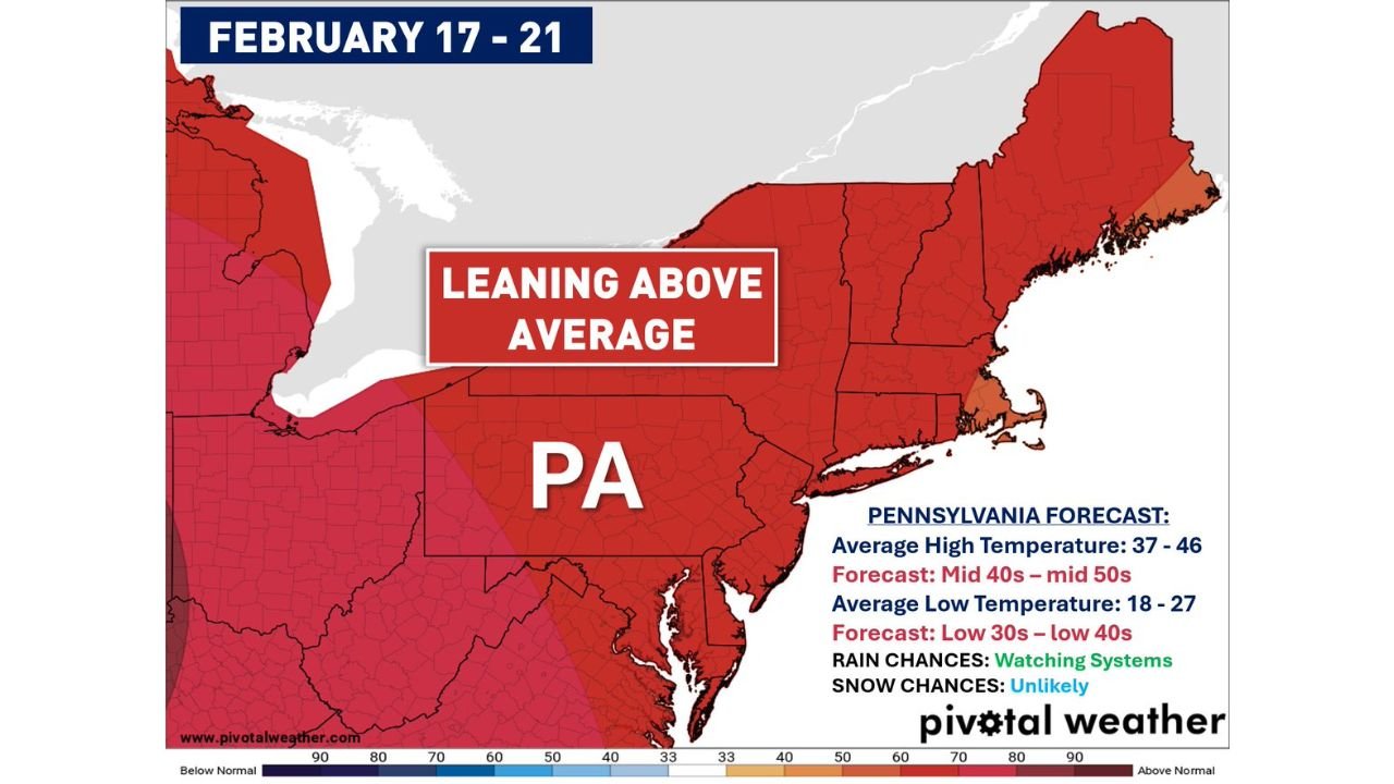
The temperature outlook map places Pennsylvania squarely in a “leaning above average” category. That shift means daytime highs are expected to rise well above mid-February climatology.
Typical average high temperatures this time of year range between 37 and 46 degrees across the state. However, projections call for afternoon highs reaching the mid-40s to mid-50s during the February 17–21 stretch.
Overnight lows, which normally fall between 18 and 27 degrees, are forecast to remain milder as well — generally in the low 30s to low 40s.
That combination signals a legitimate thaw period, particularly in areas still holding snowpack from recent winter systems.
Snow Chances Low, Rain Monitoring Ongoing
Forecast guidance indicates that snow chances are unlikely during this warmer stretch. Instead, the region will monitor potential rain systems, though no major winter weather signals are present during this time frame.
With temperatures rising above freezing both day and night in many areas, any lingering snow accumulation could gradually melt. Residents may notice runoff increases and localized wet conditions during peak afternoon warmth.
While not a dramatic heat wave by spring standards, a multi-day run of 50-degree readings in mid-February is notable — especially following a colder winter pattern.
Why the Warm-Up Makes Sense This Time of Year
As the calendar moves deeper into February, it becomes increasingly common for the jet stream to fluctuate, allowing occasional surges of milder air into the Northeast.
Longer daylight hours and shifting upper-level patterns make brief warm spells more frequent as we inch toward meteorological spring. However, Pennsylvania’s history reminds us that winter can easily reassert itself.
Colder Pattern May Return After the Thaw
Although this period features above-average temperatures, longer-range signals suggest that colder air could return after February 21. That means additional snow opportunities later in the season cannot be ruled out.
Pennsylvania rarely “calls off” winter before early April. Even after a warm stretch, pattern reversals are common.
For now, residents can expect a break from the harshest winter conditions and a chance to enjoy more comfortable afternoons outdoors.
What Residents Should Expect
During the February 17–21 period:
- Afternoon highs: Mid-40s to mid-50s
- Overnight lows: Low 30s to low 40s
- Snow chances: Unlikely
- Rain chances: Watching developing systems
The overall tone of the forecast is mild and transitional — a reminder that while winter still has time left on the calendar, early hints of spring are beginning to surface.
For continued updates on weather patterns affecting travel, events, and live music schedules across the country, visit ChicagoMusicGuide.com for the latest forecasts and coverage.