Severe Weather Threat Spreads Across Texas, Oklahoma and New Mexico as Marginal Risk Targets Fort Stockton, Abilene and Oklahoma City
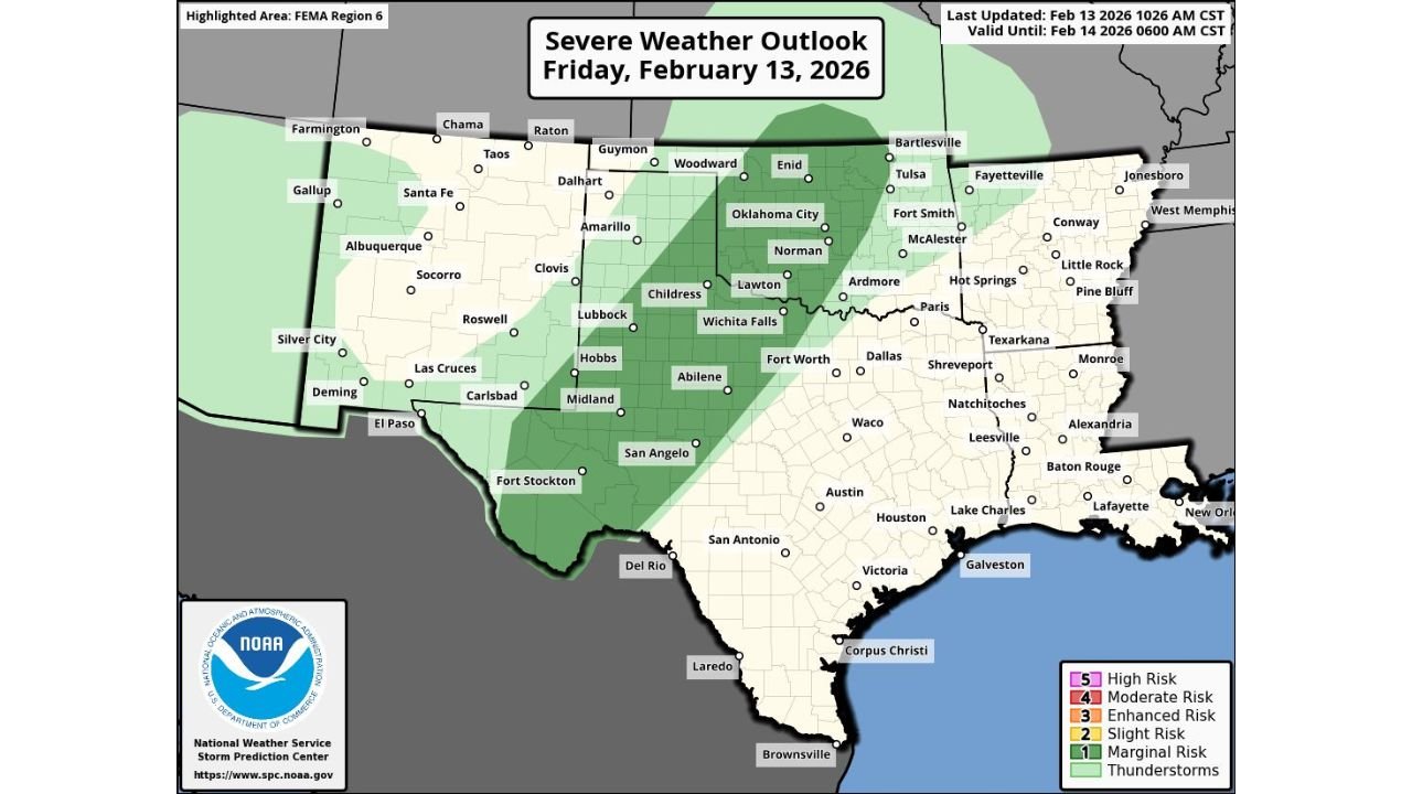
UNITED STATES — A broad but relatively low-end severe weather setup is unfolding across parts of Texas, Oklahoma, and eastern New Mexico today, with the Storm Prediction Center outlining a Marginal Risk (Level 1 of 5) stretching from the Desert Southwest into the Southern Plains. While tornadoes are not expected to be a primary concern, forecasters say damaging wind gusts and isolated severe hail remain possible through tonight.
According to the latest outlook valid through early Saturday morning, cities including Fort Stockton, Abilene, Midland, San Angelo, Wichita Falls, and Oklahoma City sit within the highlighted risk zone.
Where the Marginal Risk Is Focused
The shaded Marginal Risk corridor arcs from southern and western Texas northeastward into central and northern Oklahoma, with the following areas specifically included:
- Fort Stockton
- Midland
- San Angelo
- Abilene
- Childress
- Wichita Falls
- Lawton
- Norman
- Oklahoma City
- Portions of Lubbock and surrounding West Texas communities
Eastern New Mexico communities such as Carlsbad, Hobbs, Roswell, Las Cruces, and Silver City are also within the broader thunderstorm zone, though the higher-end severe threat remains limited.
Meanwhile, major metros like Dallas, Fort Worth, Austin, Houston, San Antonio, Shreveport, and New Orleans are outside the primary severe corridor based on this outlook.
What’s Driving Today’s Setup?
The atmospheric pattern features modest instability and sufficient wind energy to support strong to locally severe thunderstorms, especially during peak afternoon and early evening hours.
However, forecasters emphasize this is not a classic high-end severe outbreak scenario. Instead:
- Damaging straight-line winds are the main concern
- Large hail is possible in stronger cells
- Tornado risk appears minimal in this setup
The Storm Prediction Center specifically notes that tornadoes should not be a significant factor today. That distinguishes this event from more volatile springtime outbreaks across the Plains.
Timing and Impact Window
Storm development is expected to increase through the afternoon and evening, particularly across:
- West Texas into Central Texas
- Southwest and Central Oklahoma
Storms may continue into the overnight hours before gradually weakening.
Communities from Fort Stockton northeast through Abilene and into Oklahoma City should remain weather-aware, especially during the late afternoon and evening window when storms could briefly intensify.
What Residents Should Watch For
Although categorized as a Marginal Risk, isolated severe reports are still possible. Residents in the highlighted region should monitor:
- Sudden wind gusts strong enough to down tree limbs
- Hail capable of minor vehicle or roof damage
- Brief heavy downpours reducing visibility
Because tornado potential is low, the overall threat level remains limited compared to higher risk categories such as Slight, Enhanced, or Moderate.
How This Compares to Higher Risk Days
A Marginal Risk (Level 1 of 5) indicates:
- Severe storms are possible but isolated in coverage
- Most areas will see ordinary thunderstorms
- Only a few storms may briefly reach severe criteria
This is far from a widespread severe weather event, but localized impacts can still occur.
Bottom Line for Texas and Oklahoma
Today’s severe setup is a low-end but noteworthy risk across parts of West Texas and Central Oklahoma, including Fort Stockton, Abilene, and Oklahoma City. While tornadoes are not expected to be a factor, damaging winds and hail could occur in isolated stronger cells.
As always, even a Marginal Risk warrants attention — especially in areas prone to rapidly intensifying Plains thunderstorms.
For continued updates on severe weather developments across the United States, stay tuned to Chicagomusicguide.com Weather for the latest forecast breakdowns and storm analysis.