D.C. Braces for Mostly Rain Sunday, But Uncertain Storm Track Could Bring Snow or Slushy Mix North of the Beltway
WASHINGTON, D.C. — A developing Sunday storm is expected to bring mostly rain to the D.C. metro area, but uncertainty in the storm’s exact track continues to leave the door open for periods of snow or wintry mix — especially north of the Beltway.
Forecast guidance shows the low-pressure center passing south of the region, which typically favors rain for the immediate metro area. However, subtle shifts of just 50–100 miles could significantly alter precipitation types and totals across the District, Maryland, and Northern Virginia.
Timing Window: Late Morning Sunday Through Early Monday
Current projections suggest precipitation in the D.C. area will likely begin around 10 a.m. Sunday and continue through approximately 2 a.m. Monday. That broad window covers most of Sunday’s daytime and evening hours.
Confidence is moderate that at least some precipitation will reach the region. However, there remains a 20–30% chance the storm tracks far enough south to reduce totals significantly, or even produce only light amounts.
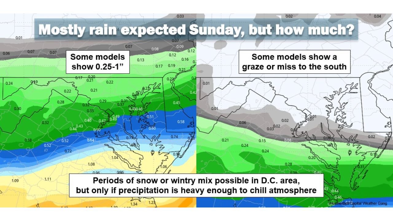
Mostly Rain Expected — But Snow Can’t Be Ruled Out
The balance of model data leans toward primarily rain for Washington, D.C. and much of the immediate metro area. Temperatures during late morning and afternoon should be warm enough to prevent wintry accumulation in most neighborhoods.
However, models indicate:
- If precipitation rates become heavy enough during the evening or overnight, atmospheric cooling could allow periods of snow or wintry mix, particularly north of the Beltway.
- Ground temperatures would need to fall closer to freezing for any accumulation.
- Any accumulation would likely be slushy and limited, favoring grassy surfaces over roadways.
Some guidance shows 0.25 to 1 inch of liquid precipitation possible in parts of the region. Other scenarios show much lighter totals if the system trends farther south.
Why the Track Matters So Much
The storm’s low-pressure center is forecast to pass south of the D.C. area. That setup typically brings milder air north of the system, favoring rain.
But the exact latitude of that track is critical:
- A slightly farther north track could increase rainfall totals.
- A slightly farther south track could reduce overall precipitation.
- A deeper or more organized system could enhance cooling on the northern side, increasing snow chances late Sunday night.
Model spreads remain notable, which is why confidence in specific totals is still lower than usual for this time frame.
Flooding Concerns If Rain Is Heavier
If higher-end rainfall totals materialize — closer to the 1-inch mark — localized flooding could become a concern. This risk would be greatest:
- In areas with remaining snowpack
- In urban locations with poor drainage
- Farther south in the region where rainfall would be more persistent
Runoff from rain falling onto existing snowpack could increase water levels in smaller streams and low-lying roadways.
Bottom Line for D.C.
- Most likely scenario: A rainy Sunday with little to no accumulation.
- Secondary possibility: Brief snow or wintry mix Sunday evening or overnight, mainly north of the Beltway.
- Lower probability outcome: The storm tracks south and produces lighter totals overall.
Residents should prepare for wet conditions and monitor updates, especially if traveling late Sunday into early Monday.
For continuing updates on this evolving East Coast storm system and how it could impact travel, events, and commutes, stay with ChicagoMusicGuide.com Weather.