Sierra Nevada Braces for 4 to 8 Feet of Snow as Life-Threatening Atmospheric River Targets California with 100+ MPH Winds
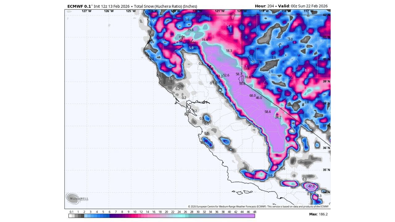
SIERRA NEVADA, CALIFORNIA — A powerful atmospheric river is expected to unleash a dangerous and potentially life-threatening winter storm across the Sierra Nevada range next week, with forecast models showing 4 to 8 feet of snow in higher elevations from Monday through Thursday. Winds could exceed 55 mph at lower elevations and top 100 mph at high elevations, creating extreme travel and avalanche conditions.
The event is shaping up to be one of the more significant mountain storms of the season for California.
4 to 8 Feet of Snow Expected in the Sierra
Forecast guidance indicates prolonged heavy snowfall across much of the central and northern Sierra Nevada, including areas near:
- Lake Tahoe
- Yosemite National Park
- Mammoth Mountain
- High-elevation passes along Highway 50 and Interstate 80
Snowfall totals in the most favored terrain could reach 48 to 96 inches, with some localized peaks potentially exceeding that range depending on storm duration and moisture intensity.
The heaviest snowfall is projected along the western slopes of the range, where strong Pacific moisture will be forced upward by the mountains — a process known as orographic lift.
Powerful Atmospheric River Driving the Storm
This event is being fueled by a robust Pacific atmospheric river, a long corridor of concentrated moisture aimed directly at California’s central coastline and Sierra region.
As the moisture surges inland, colder air at higher elevations will allow heavy precipitation to fall primarily as snow across the mountain spine.
Lower elevations, including parts of the Sacramento Valley and foothills, could see significant rainfall, raising concerns for runoff and localized flooding.
Extreme Wind Threat at High Elevations
In addition to the snowfall, strong winds are expected to significantly increase impacts.
Forecast models show:
- Wind gusts over 55 mph across exposed ridgelines
- High-elevation gusts potentially exceeding 100 mph
These winds could create whiteout conditions in open areas and produce dangerous drifting snow across mountain highways. Blowing snow combined with heavy snowfall may reduce visibility to near zero at times.
Power outages are also possible in mountain communities due to falling trees and infrastructure stress.
Travel Could Become Nearly Impossible
Major mountain routes such as:
- Donner Pass (Interstate 80)
- Echo Summit (Highway 50)
- Access roads to Lake Tahoe and Mammoth Lakes
could face extended closures if snowfall and wind projections materialize.
Caltrans and local officials will likely monitor conditions closely as the storm approaches, with chain controls and potential shutdowns possible during peak snowfall periods.
Backcountry travel will become especially dangerous due to avalanche risk, particularly as heavy snow loads accumulate rapidly.
Timing: Monday Through Thursday
The storm is expected to begin impacting the Sierra region on Monday, intensifying through midweek before tapering late Thursday.
Because the system spans multiple days, snow totals will accumulate steadily, with several periods of heavy snowfall likely.
The prolonged nature of the atmospheric river means impacts will not be brief — instead, mountain communities could face several consecutive days of hazardous weather.
A High-Impact Week Ahead for California Mountains
While beneficial for long-term water supply and snowpack levels, storms of this magnitude also bring serious safety concerns.
Residents and travelers in the Sierra Nevada region should prepare for:
- Extended travel disruptions
- Potential power outages
- Dangerous outdoor conditions
- Avalanche risk in steep terrain
As the system draws closer, snowfall projections and wind expectations may be refined further.
For ongoing updates on major winter storms, atmospheric river events, and national weather impacts, stay tuned to ChicagoMusicGuide.com for continuing coverage.