Northern Stream Timing Key as New Jersey and New York City Watch Sunday–Monday Storm With 3–6 Inch Snow Possible if Everything Phases Just Right
UNITED STATES — A developing coastal storm set to impact the Mid-Atlantic and Northeast Sunday into Monday is walking a fine line, and for areas north of Connecticut, forecasters are not especially bullish on significant snowfall. But for parts of New Jersey and New York City, the setup is more nuanced — and could still deliver a measurable snowfall if atmospheric pieces align just right.
Based on the latest model guidance shown in the ECMWF and NAM panels valid early Monday morning (February 16), the storm’s outcome hinges on one critical factor: how quickly the northern stream energy phases with the southern system and pulls colder air into the region.
Rain Dominates to the South, Snow Line Hovers Near NJ and NYC
The ECMWF depiction valid around 6 a.m. Monday shows a coastal low tracking south of Long Island, with widespread precipitation across Maryland, Delaware, southern Pennsylvania, New Jersey, and southern New York.
- Heavier precipitation remains centered offshore and south of Long Island.
- Much of New Jersey and the New York City metro sits near the critical rain/snow transition zone.
- Areas north of Connecticut show lighter overall QPF and limited snow potential.
The precipitation shield extends into eastern Pennsylvania and northern New Jersey, where colder air may try to press southward. However, model signals suggest the heaviest forcing stays just far enough offshore to limit widespread heavy snowfall inland — unless phasing improves.
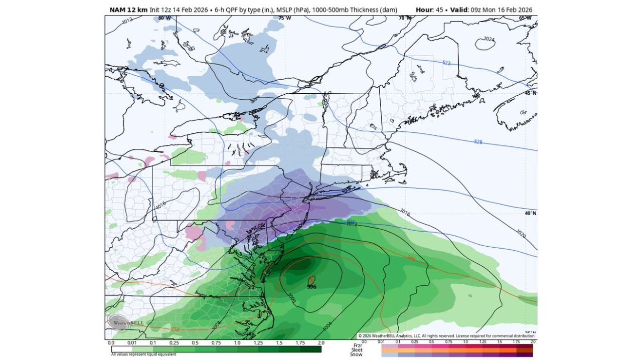
NAM Suggests Slightly Better Snow Chances for NJ and NYC
The NAM model, valid around 9 a.m. Monday, shows a similar low-pressure center offshore, but with a somewhat more organized precipitation band wrapping northwest toward central and northern New Jersey and into New York City.
In this scenario:
- Moderate precipitation overlaps marginal cold air.
- Snow or a wintry mix becomes more plausible across parts of north-central New Jersey, interior NYC boroughs, and possibly the Lower Hudson Valley.
- Southern New Jersey and coastal zones lean more rain.
Still, this is not a high-confidence snowstorm setup — it’s a boundary battle.
Why Northern Stream Phasing Matters So Much
The key phrase in this forecast is “how fast the northern stream phases.”
If the northern branch of the jet stream digs in more quickly:
- Colder air would be pulled south sooner.
- The rain/snow line would shift toward the coast.
- A band of 3–6 inches could develop across parts of New Jersey and the New York City metro area.
If the phasing is delayed:
- The storm remains primarily rain for coastal sections.
- Snow accumulations would be limited to interior elevations.
- NYC could see mostly rain with perhaps brief mixing at the end.
Right now, guidance does not strongly favor a robust phase — which is why confidence remains tempered.
North of Connecticut: Limited Snow Signals
Model guidance indicates that areas north of Connecticut into interior New England are not well positioned for heavy snowfall with this particular track.
- Precipitation is lighter and more scattered.
- The storm’s main energy stays offshore and south.
- Only minor accumulations appear likely in most northern zones.
That said, subtle track shifts of even 50–100 miles can dramatically change snow totals along the I-95 corridor.
What Happens Next?
This is a classic coastal storm scenario where:
- Small timing changes alter snow maps significantly.
- Surface temperatures hover near freezing.
- Precipitation intensity determines whether the atmosphere cools enough for snow.
At this stage, forecasters are cautious. The “everything goes right” scenario supports 3–6 inches across parts of NJ and NYC, but that requires near-perfect alignment of phasing and cold air.
Otherwise, expect:
- Mostly rain south and along the immediate coast.
- A mix changing to light snow inland.
- Marginal accumulations except in higher elevations.
Bottom Line for NJ and NYC
This is not a slam-dunk snowstorm — but it’s not off the table either.
The next 24–36 hours of model runs will determine whether:
- The storm trends colder and snowier,
or - It remains a primarily rain event with limited wintry impact.
Residents across New Jersey and New York City should monitor updates closely, especially if travel plans are scheduled late Sunday into early Monday.
Weather stories like this can evolve quickly. Stay tuned to Chicagomusicguide.com for continued national weather updates and detailed breakdowns as this Sunday–Monday system approaches the Northeast.