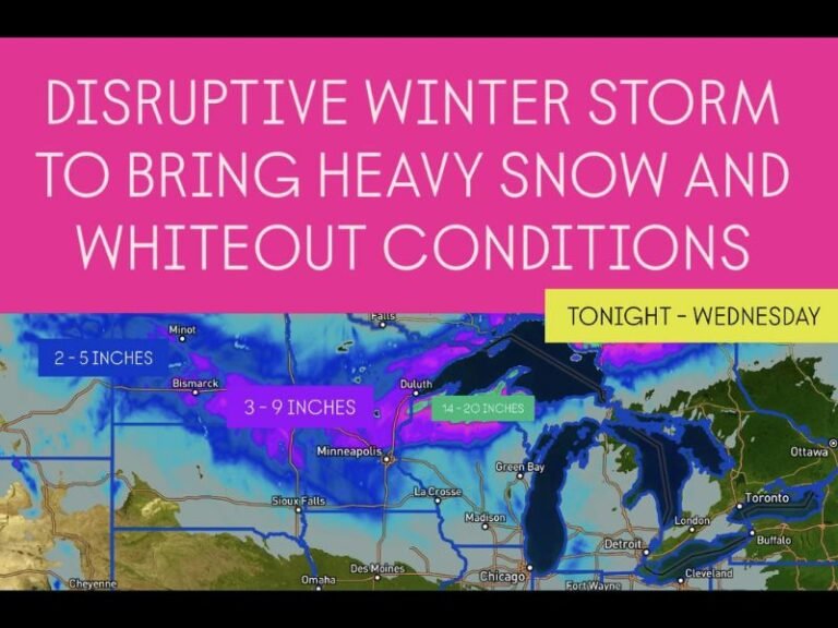
Ohio Valley Braces for Possible Severe Storms Thursday as Powerful Jet Stream Targets Kentucky, Tennessee and Indiana
LOUISVILLE, KENTUCKY — Severe weather concerns are not ending with the weekend. Forecast models now show a potential setup developing on Thursday, February 19, as a broad upper-level trough and powerful jet stream move into the Ohio Valley region, placing parts of Kentucky, Tennessee, Indiana, and southern Ohio under increasing attention.
While moisture remains the primary limiting factor at this stage, forecasters say that if richer Gulf moisture pushes farther north than currently modeled, the environment could support a more organized severe weather event.
Strong Jet Stream Aims Directly at the Ohio Valley
Medium-range guidance shows a pronounced 500 mb jet streak stretching from the southern Plains into the Mid-South and Ohio Valley, with wind speeds exceeding 90–110 knots in the core. The strongest upper-level forcing appears aligned from Arkansas and Tennessee northeastward into Kentucky and southern Indiana.
This configuration typically enhances:
- Large-scale lift
- Wind shear supportive of storm organization
- The potential for line segments or rotating storms
The jet orientation places the lower Ohio Valley squarely beneath favorable upper-level dynamics, increasing the need to monitor trends over the coming days.
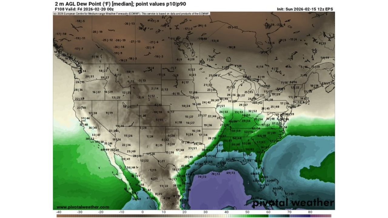
Moisture Return: The Key Question
At present, model projections show weak to moderate low-level moisture, with 2-meter dew points largely confined to the Gulf Coast and Deep South. However, modest moisture return is indicated pushing northward into western Tennessee and western Kentucky by Thursday.
If dew points climb into the low to mid-50s°F across portions of Kentucky and Tennessee, instability could increase enough to support stronger thunderstorms. Currently, instability projections remain marginal, which could keep the severe threat limited.
Meteorologists note that even slight upward trends in moisture could significantly change the outlook.
Instability and CAPE: Marginal but Not Zero
Forecast maps show mixed-layer CAPE values generally limited across much of the Ohio Valley, with stronger instability remaining closer to the Gulf Coast. However, a narrow axis of instability may extend northward into:
- Western Tennessee
- Western Kentucky
- Southern Indiana
If this instability overlaps with the strong wind shear provided by the jet stream, thunderstorms could organize more efficiently.
Sounding data near the lower Ohio Valley indicates sufficient wind shear and low-level helicity to support rotating storms if instability improves. While tornado probabilities appear low at this time, forecasters stress that conditional risks cannot be ruled out.
What Could Happen on Thursday?
The most likely scenario at this point appears to be:
- A line of thunderstorms moving east across the region
- Gusty winds as the primary threat
- Isolated stronger cells if instability trends upward
However, if moisture return exceeds expectations, the environment could support:
- More organized severe storms
- Damaging straight-line winds
- A limited tornado threat
The timeframe for greatest concern currently centers on Thursday afternoon into early evening, when daytime heating could modestly enhance instability ahead of the approaching trough.
Why This Setup Matters for the Midwest and Ohio Valley
This pattern marks another potential severe weather episode during a transitional late-winter period. Systems this time of year often feature strong wind shear but limited instability. The balance between those two ingredients will determine the final outcome.
Communities in Louisville, Nashville, Evansville, Cincinnati, and Indianapolis should monitor forecast updates through the week. Even marginal instability paired with strong upper-level dynamics can produce impactful storms.
Forecasters emphasize that trends will be closely watched, particularly regarding northward moisture transport from the Gulf of Mexico. Any shift in dew point forecasts could elevate the overall severe weather outlook.
As the Ohio Valley heads toward Thursday, attention turns to how moisture, instability, and wind dynamics ultimately align. For continued updates on developing storm systems and severe weather trends across the United States, visit ChicagoMusicGuide.com.