Southern California and Central Valley Face Rare Tornado Risk Monday as Storm Prediction Center Flags Dual Marginal Zones
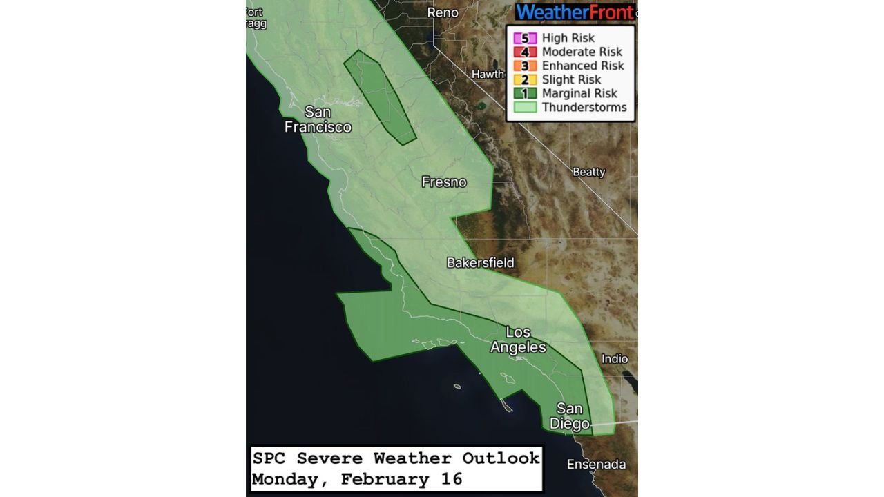
LOS ANGELES, CALIFORNIA — Portions of California are under a Marginal Risk (Level 1 of 5) for severe weather on Monday, February 16, with the Storm Prediction Center outlining two separate areas of concern: the Southern California coast, including Los Angeles and San Diego, and the Central Valley, including Sacramento.
While widespread severe weather is not expected, forecasters say a brief tornado or two and isolated damaging wind gusts cannot be ruled out in these targeted zones.
Southern California Coast: Morning Cold Front Could Trigger Brief Tornado
The first area of concern stretches along the Southern California coastline, encompassing Los Angeles County, Orange County, and San Diego County. A robust line of storms is expected to move ashore late Monday morning into the early afternoon as a cold front pushes inland.
Forecasters indicate:
- Instability will be relatively weak
- Low-level wind shear may be strong enough to support rotation
- A narrow window exists for a brief tornado or isolated damaging wind gusts
Even with limited instability, the combination of a strong frontal boundary and favorable wind profiles can occasionally produce short-lived tornado spin-ups in coastal California. The primary threat appears to be gusty winds embedded within the convective line.
Cities including Los Angeles and San Diego may experience heavy rainfall and locally strong wind gusts as the front moves inland.
Central Valley Including Sacramento: Conditional Afternoon Supercell Risk
A second Marginal Risk area is positioned over the Central Valley, including Sacramento, Fresno, and surrounding communities. Unlike the coastal threat, this risk is more conditional and dependent on how the atmosphere evolves after early-day precipitation.
If skies partially clear during the afternoon, colder temperatures aloft combined with backed low-level flow within the valley could allow:
- One or two low-topped supercells
- A brief tornado risk
- Small hail
Forecasters emphasize that timing will be critical. Should instability increase even modestly following the morning rainfall, rotating storms could develop in localized pockets of the valley.
Sacramento sits within this highlighted zone, where clearing and daytime heating could determine whether storms intensify or remain ordinary showers.
Why Severe Weather in California Is Unusual
Although tornadoes are far less common in California compared to the Plains or Southeast, they are not unprecedented. Late-winter systems often feature strong wind dynamics but limited instability. When those ingredients overlap just enough, isolated severe weather can occur.
This particular setup involves:
- A strengthening cold front
- Favorable low-level wind shear
- Marginal but sufficient instability
The Marginal Risk classification indicates isolated severe storms are possible but not widespread.
What Residents Should Expect Monday
For Southern California, the primary window of concern is late morning through early afternoon. For the Central Valley, the focus shifts toward mid-to-late afternoon depending on cloud cover and heating trends.
Residents in:
- Los Angeles
- San Diego
- Sacramento
- Fresno
should remain weather-aware, particularly if warnings are issued.
Most areas will likely see periods of rain and gusty winds without significant severe impacts. However, isolated brief tornadoes or small hail cannot be ruled out within the outlined Marginal Risk zones.
As Monday approaches, forecasters will continue monitoring real-time trends in instability and storm organization. For continued updates on California severe weather, storm timing, and regional forecasts across the United States, visit ChicagoMusicGuide.com.