Severe Storm Threat Expands Toward Illinois, Iowa, and Missouri as Powerful Jet Streak Targets the Ohio Valley This Thursday
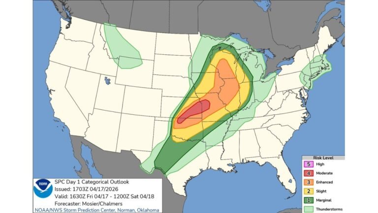
ILLINOIS — A developing severe weather setup for Thursday, February 19 is drawing new attention across the Midwest, as the Storm Prediction Center outlines a risk centered over the Ohio Valley — with western Illinois, southeast Iowa, and northeast Missouri now emerging as a potential expansion zone.
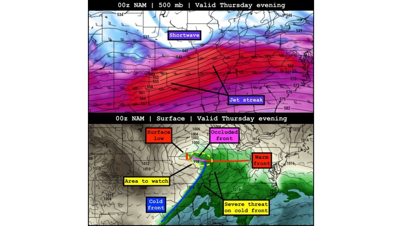
Forecast guidance shows a low-amplitude shortwave trough ejecting into the central United States while a robust jet streak overspreads the region. That combination is expected to induce surface low development and sharpen frontal boundaries by Thursday evening.
Meteorologists are closely monitoring areas immediately ahead of the surface low, particularly near St. Louis, western Illinois, southeast Iowa, and northeast Missouri, where ingredients may align for stronger storms.
SPC Risk Area Currently Centered on the Ohio Valley
The Storm Prediction Center’s outlined risk area for Thursday is primarily focused over the Ohio Valley, stretching near Indianapolis and Nashville. The greatest severe potential in the current outlook appears tied to the advancing cold front and the warm sector feeding northward from the Gulf Coast.
Key setup features include:
- A strengthening jet streak aloft, enhancing wind shear
- Adequate moisture returning north into the Midwest
- Surface low development increasing low-level wind fields
This dynamic pattern suggests storms capable of producing damaging winds, hail, and possibly tornadoes, especially where instability overlaps with strong wind shear.
Illinois, Southeast Iowa, and Northeast Missouri Marked as Area to Watch
While the primary risk is centered east, forecasters are highlighting a secondary zone just ahead of the surface low — roughly across western Illinois into southeast Iowa and northeast Missouri.
Here’s why that corridor matters:
- Cold air aloft associated with the shortwave may steepen lapse rates
- Enhanced surface vorticity near the low could support rotation
- Moisture wrapping back toward the low may fuel low-topped supercells
Low-topped supercells are typically compact but can produce all hazards, including isolated tornadoes, especially in early-season setups like this one.
Graphics accompanying the forecast depict a hatched monitoring zone west of St. Louis — signaling the possibility of a future risk upgrade if trends continue.
Surface Low and Frontal Structure Key to Thursday Evening Evolution
Model projections for Thursday evening show:
- A developing surface low across the Midwest
- An occluded front wrapping near the low center
- A warm front extending eastward
- A cold front surging southward with the main severe threat
The most intense storms may initially develop along or just ahead of the cold front. However, the “area to watch” near the low center could support isolated but potentially intense storms given the colder air aloft and strong upper-level winds.
If moisture return is slightly stronger than currently forecast, expansion of severe probabilities into parts of Illinois and adjacent states would not be surprising.
Timing and What to Expect
The greatest concern window appears to be Thursday afternoon into Thursday evening, as the jet streak maximizes overhead and the surface low deepens.
Residents in:
- Western Illinois
- Southeast Iowa
- Northeast Missouri
- The Ohio Valley region
should monitor forecast updates closely as refined outlooks are issued.
While this is not yet a widespread high-end outbreak signal, the pattern supports at least scattered severe storms, with localized stronger development possible in the expansion corridor.
As always with early-season systems, small shifts in track or moisture can significantly alter impact zones.
Stay weather-aware Thursday, especially if you’re near the Illinois–Missouri–Iowa border region or east into the Ohio Valley.
For continued updates on major weather patterns affecting the Midwest and beyond, keep following ChicagoMusicGuide.com.