Major Snow Zone Emerging From Pennsylvania to Massachusetts as GFS-AI Model Shows 1–1.8 Inches Liquid Equivalent
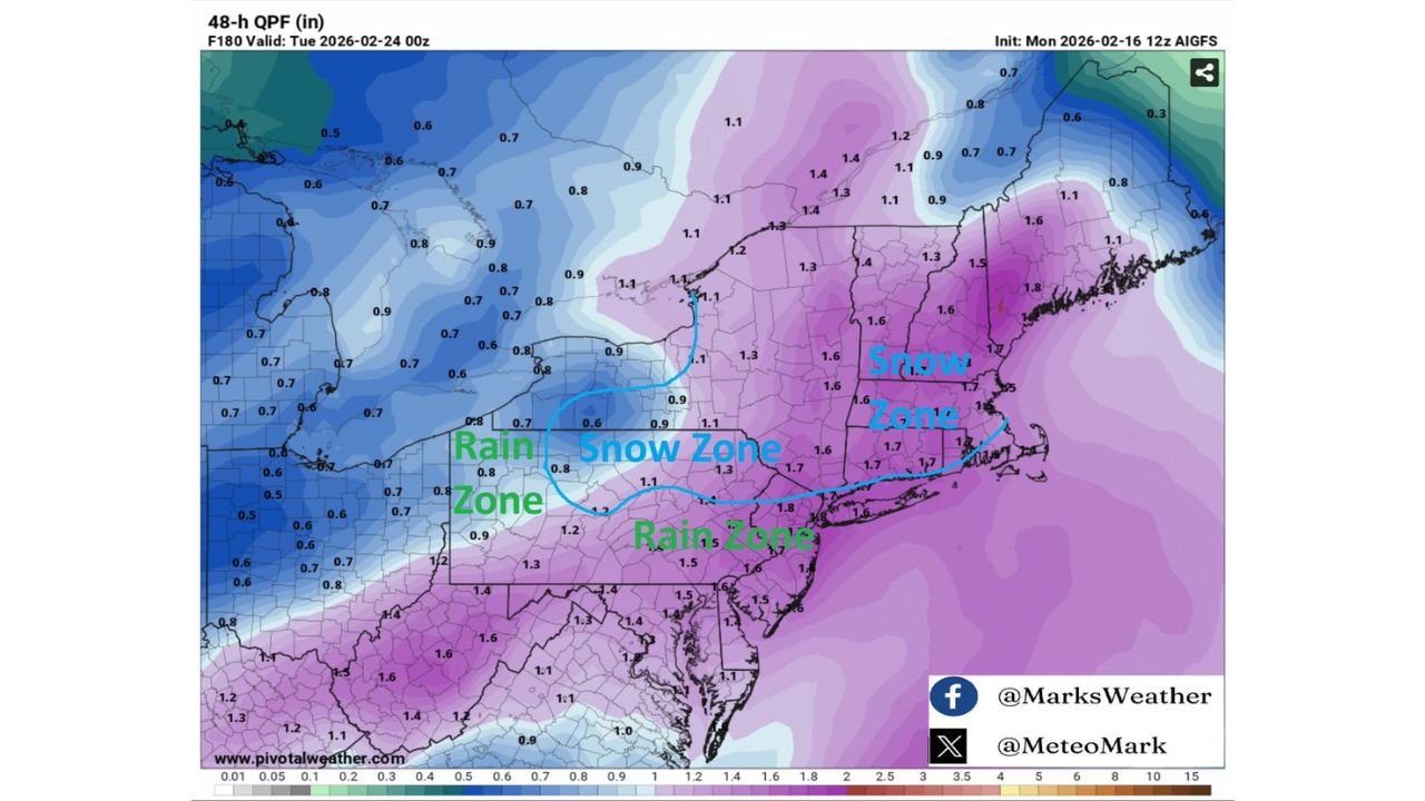
HARRISBURG, PENNSYLVANIA — A new 48-hour precipitation forecast from the GFS-AI model is highlighting a potentially significant snow zone stretching from central Pennsylvania through southern New York and into much of Connecticut and Massachusetts, with liquid totals suggesting the possibility of double-digit snowfall in some areas if temperatures remain cold enough.
The model run ending 7 p.m. Monday, February 23 (valid 0z February 24) shows widespread 1.0 to 1.8 inches of liquid equivalent precipitation across the Northeast. Forecasters have outlined a surface freezing line to estimate where precipitation would most likely fall as snow versus rain.
Snow Zone Positioned Across Interior Northeast
Based on the drawn freezing boundary, the most likely accumulating snow zone includes:
- Central and eastern Pennsylvania
- Southern and central New York
- Northern New Jersey
- Connecticut
- Rhode Island
- Much of Massachusetts, including interior sections
Within this corridor, liquid totals frequently range between 1.2 and 1.8 inches. Using a standard 10:1 snow ratio, that could translate to 10 to 18 inches of snowfall, depending on exact temperatures and storm dynamics.
Cities potentially within the snow zone include:
- Harrisburg
- Scranton
- Albany
- Hartford
- Springfield, MA
- Portions of the Boston metro west of the immediate coastline
Rain Zones South and West of the Freezing Line
Areas south of the freezing boundary — including much of southern New Jersey, southeastern Pennsylvania near Philadelphia, and portions of coastal Long Island — appear more likely to experience predominantly rain, especially closer to the coast where marine air influence is stronger.
Farther west, portions of western Pennsylvania and western New York show lighter liquid totals, generally in the 0.6 to 0.9 inch range, and may fall near the transition zone depending on how temperatures evolve.
Because this forecast hinges on the exact placement of the freezing line, even a small northward or southward shift could dramatically alter who sees heavy snow versus cold rain.
Liquid Totals Support Significant Accumulation Potential
The standout feature of this forecast is the magnitude of the liquid precipitation. Broad areas show over 1 inch of QPF, with localized maxima approaching 1.7 to 1.8 inches across parts of southern New England and eastern Pennsylvania.
If surface temperatures remain at or below freezing across the snow zone, snowfall amounts could become impactful. However, snow ratios may vary depending on:
- Boundary layer temperatures
- Storm intensity
- Timing of peak precipitation
Heavier snowfall rates would be possible in areas where dynamic cooling reinforces colder surface air.
Forecast Sensitivity Remains High
Forecasters caution that this model depiction represents one scenario. The exact freezing line placement is critical. Communities located near the transition zone — including parts of northern New Jersey, the Lower Hudson Valley, and central Connecticut — could see a mix of rain and snow depending on minor thermal changes.
Still, the overall signal from this run shows a well-defined snow corridor across the interior Northeast, supported by substantial liquid precipitation totals.
Residents across Pennsylvania, New York, Connecticut, Rhode Island, and Massachusetts should monitor updated forecasts closely over the coming days, especially if they fall within or near the outlined snow zone.
As this late-winter system evolves, ChicagoMusicGuide.com will continue tracking model trends, freezing line shifts, and snowfall potential across the Northeast. For continued coverage of major storm developments and regional weather impacts, visit ChicagoMusicGuide.com.