Thursday Tornado Risk Expands Across Illinois, Indiana, and Missouri as First Major Midwest Threat of the Year Takes Shape
SPRINGFIELD, ILLINOIS — The first significant tornado threat of the year may be setting up across portions of the Midwest on Thursday, with forecast guidance highlighting an arc of enhanced severe weather potential stretching from Missouri through Illinois and into Indiana and western Ohio. While specific storm details remain uncertain, the broader atmospheric pattern supports the development of low-topped supercells capable of producing tornadoes, hail, and damaging winds.
Forecasters indicate that Thursday’s system bears close monitoring as confidence grows in a focused corridor of severe potential.
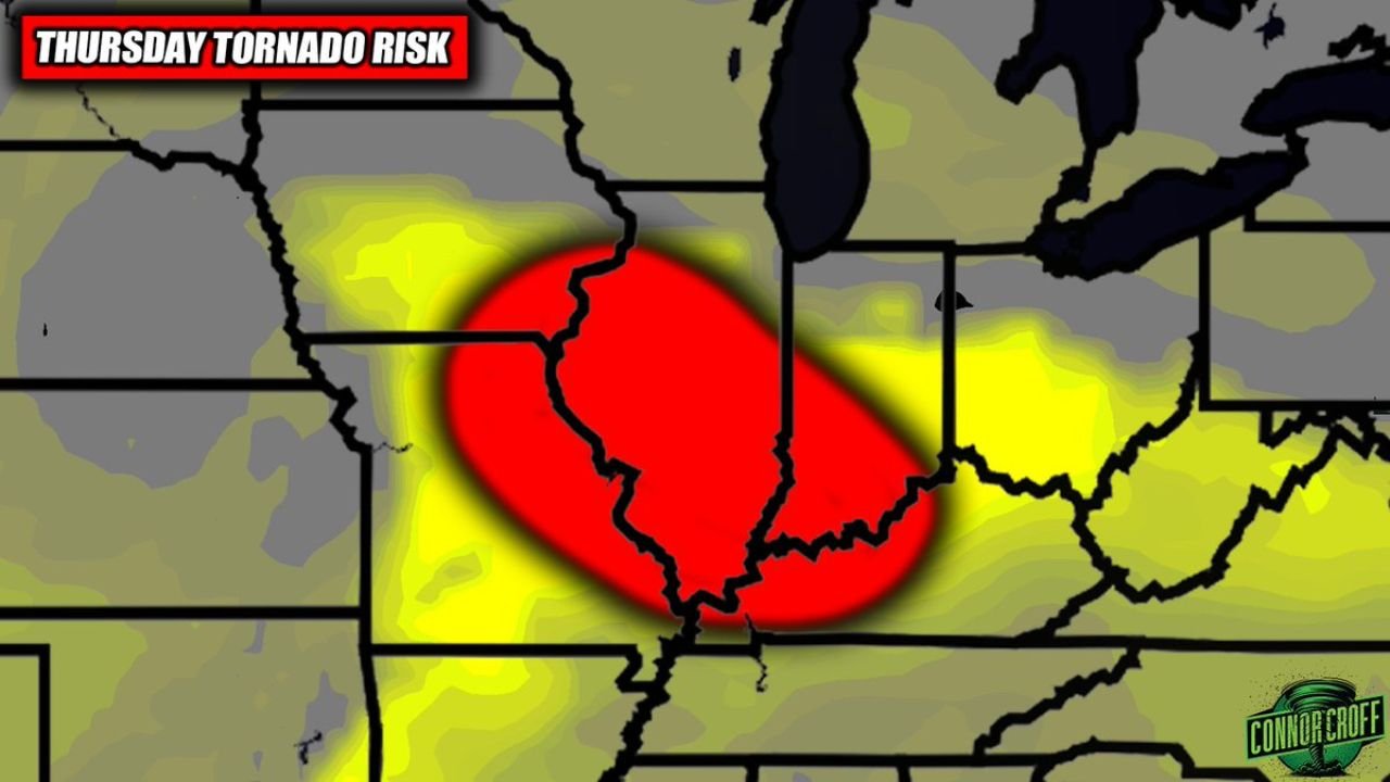
Core Risk Zone Centers on Illinois and Indiana
Forecast maps show the highest tornado potential centered over:
- Central and southern Illinois
- Much of Indiana
- Eastern Missouri
- Extending eastward into western Ohio
The highlighted risk area includes major cities such as:
- Springfield, Illinois
- Peoria
- Champaign
- Indianapolis
- Terre Haute
- Portions of St. Louis
This corridor represents the most favorable overlap of wind shear and instability, conditions necessary for rotating storms capable of producing tornadoes.
Low-Topped Supercells Could Drive Tornado Potential
Unlike classic spring setups with towering thunderstorms, this event may feature low-topped supercells. These storms do not appear exceptionally tall on radar but can rotate efficiently due to strong wind shear in the lower atmosphere.
Low-topped supercells are known for:
- Brief but potentially strong tornadoes
- Localized damaging wind gusts
- Large hail
The synoptic pattern — including a strengthening low-pressure system and advancing warm sector — supports the development of discrete rotating storms rather than just a linear squall line.
Timing: Thursday Afternoon and Evening
The most likely window for severe development appears to be Thursday afternoon into early evening, when daytime heating maximizes instability across the warm sector.
Storms are expected to form and then track northeast across Illinois and Indiana, potentially impacting travel and outdoor activities during peak afternoon hours.
As storms push east toward Ohio, some weakening may occur depending on how instability evolves later in the day. However, the Illinois–Indiana corridor remains the focal point for the strongest severe threat at this time.
Specifics Still Uncertain, But Pattern Supports Severe Setup
Forecasters emphasize that while the overall environment supports severe weather, exact storm placement, tornado intensity, and coverage remain uncertain several days in advance.
Key variables still being monitored include:
- Surface dew point placement
- Exact warm front location
- Timing of upper-level energy
- Storm mode (discrete cells versus clustered convection)
Even with uncertainties, the synoptic setup strongly suggests that all severe hazards — including tornadoes — are possible within the highlighted region.
Midwest Residents Urged to Stay Weather-Aware
Communities across Illinois, Indiana, Missouri, and western Ohio should begin reviewing severe weather safety plans ahead of Thursday. While this is not yet a confirmed outbreak scenario, the environment may be supportive enough for isolated tornadoes and scattered severe storms.
Residents in cities such as Springfield, Peoria, Champaign, Indianapolis, Terre Haute, and St. Louis should monitor forecast updates as the system approaches.
As this developing severe weather threat evolves, ChicagoMusicGuide.com will continue tracking model trends, tornado potential, and timing details across the Midwest. For ongoing coverage of regional weather threats and safety updates, visit ChicagoMusicGuide.com.