Thursday Severe Weather Threat Targets Illinois, Indiana, Missouri and Ohio Valley With Tornado and 60+ MPH Wind Risk
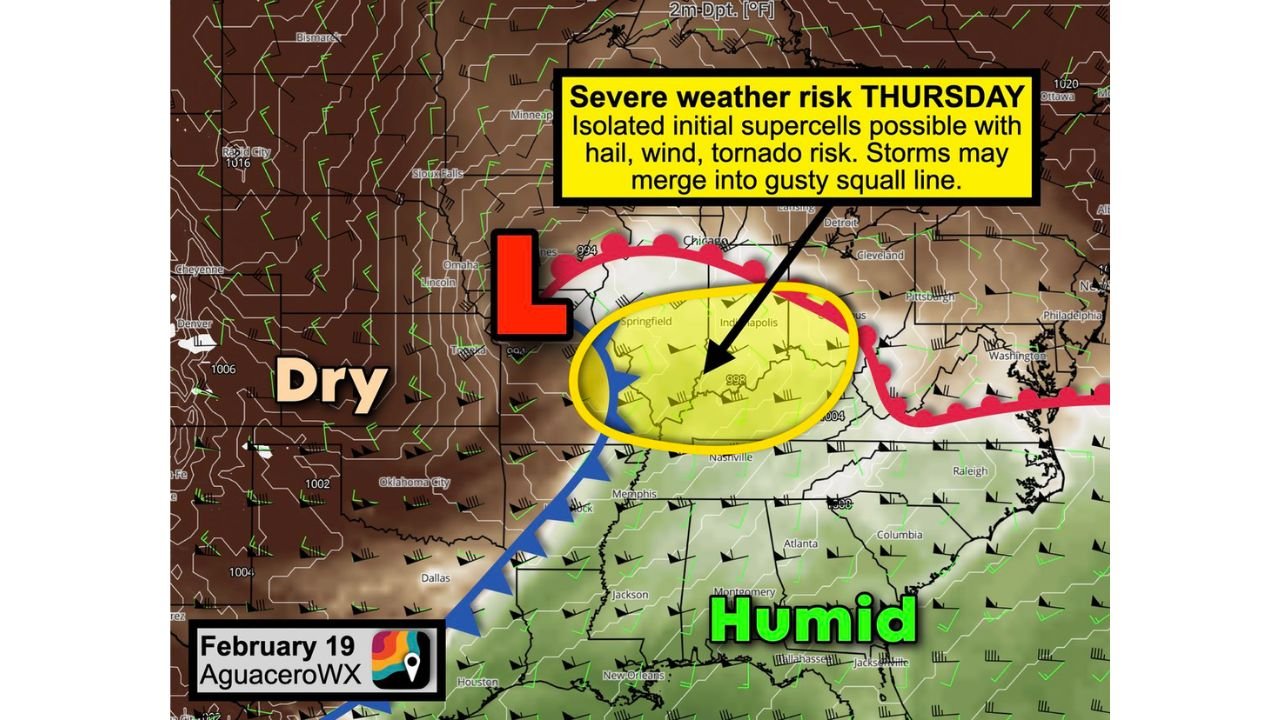
OHIO VALLEY — A developing storm system is setting the stage for what could become the first meaningful severe weather threat of the season across parts of the Midwest and Ohio Valley on Thursday, February 19. Forecast guidance highlights a Level 2 out of 5 Slight Risk, covering cities including Indianapolis, St. Louis, Carbondale, Cincinnati, Louisville, and Lexington-Fayette, with surrounding communities also in the risk zone.
Meteorologists indicate that while some details remain uncertain, the overall setup supports the development of low-topped supercells capable of producing tornadoes, large hail, and damaging wind gusts. The evolving pattern suggests a dynamic and potentially impactful afternoon and evening for millions across the region.
Why This Setup Is Concerning
A strengthening area of low pressure is expected to track through northern Missouri and the Corn Belt, pulling warm, humid air northward into Illinois, Indiana, and parts of Kentucky and Ohio. This influx of moisture will provide the necessary instability — essentially the fuel — for thunderstorm development.
At the same time, the jet stream swinging overhead will enhance wind shear, meaning winds will change speed and direction with height. This combination of moisture, instability, and wind shear is a classic ingredient for rotating thunderstorms, also known as supercells.
Forecasters emphasize that early storms could remain discrete long enough to pose an isolated tornado threat, particularly in areas from central Missouri through central and southern Illinois into Indiana and western Kentucky. Even brief tornadoes are possible under this type of setup.
Tornado, Hail and Damaging Wind Potential
The current outlook suggests that isolated supercells may initially form ahead of a cold front. These storms could produce:
- Brief tornadoes
- Hail
- Localized wind gusts exceeding 60 mph
As the evening progresses, storms are expected to merge into one or more lines or clusters, shifting the primary hazard toward widespread straight-line winds. Gusty squall lines capable of producing 60+ mph winds may impact cities including Indianapolis, Louisville, Cincinnati, and Lexington-Fayette before pushing east.
The severe threat zone stretches across parts of eastern Missouri, much of Illinois and Indiana, western Ohio, and northern Kentucky, with the highest concern centered within the highlighted Slight Risk area.
Timing and What Residents Should Watch
Thursday afternoon into Thursday evening appears to be the primary window for storm development. Communities south of Interstate 80 in Illinois and Indiana may see the greatest instability, but storms could track northeast through portions of northern Illinois as well before weakening.
Storm mode — whether isolated supercells or a more organized line — will determine the exact severity and tornado potential. That clarity will come into better focus in the hours leading up to the event.
Residents across St. Louis, Springfield, Indianapolis, Louisville, Cincinnati, and surrounding areas should stay weather-aware, ensure mobile alerts are enabled, and have a plan in place in case warnings are issued.
Severe weather season can ramp up quickly across the Midwest, and this system may serve as an early reminder that winter’s quiet pattern can transition rapidly into springlike volatility.
For continuing updates on this developing Thursday severe weather threat, and coverage of major weather events impacting music cities and touring regions across the country, keep checking ChicagoMusicGuide.com for the latest forecasts and regional alerts.