Thursday Severe Weather Outbreak Targets Illinois, Indiana, Iowa and Ohio Valley With Tornado and Large Hail Threat
CHICAGO, ILLINOIS — A developing storm system is setting the stage for a potentially dangerous Thursday severe weather event across parts of the Midwest, with model guidance highlighting Illinois, Indiana, Iowa, Missouri, Ohio and Kentucky as areas to watch closely. Forecast data valid for Thursday, February 19, 2026 (4 p.m. CST) shows a dynamic setup capable of producing tornadoes, large hail and damaging winds, especially during the afternoon and early evening hours.
The evolving pattern features a strengthening low-pressure system, a sharpening dryline, and a warm, unstable air mass surging northward into the Ohio Valley. High-resolution guidance suggests multiple storm modes may develop — including discrete supercells and later line segments.
Dryline Supercells Could Ignite Across Illinois and Iowa
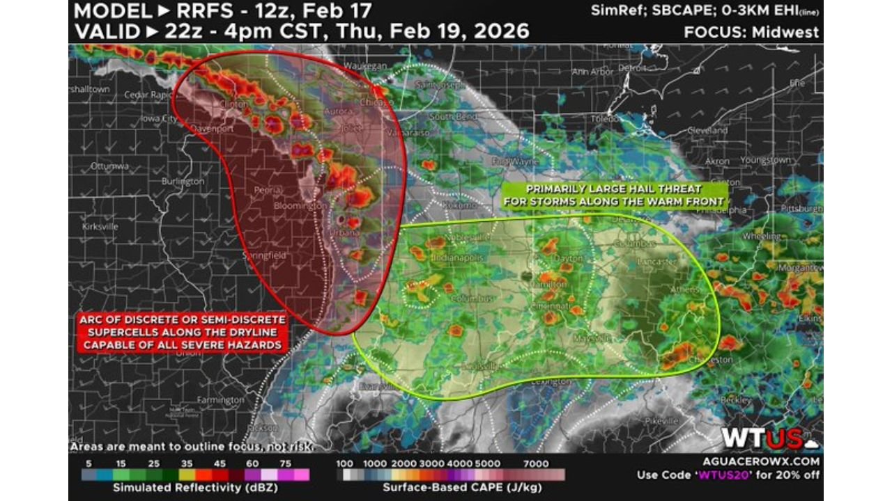
The latest RRFS model guidance highlights an arc of discrete to semi-discrete supercells developing along the primary dryline stretching from eastern Iowa into central and western Illinois during the afternoon.
Cities including Cedar Rapids, Davenport, Peoria, Springfield, Bloomington and Champaign appear near or just east of the dryline corridor where instability and wind shear overlap. In this zone, storms would have access to:
- Strong surface-based CAPE
- Favorable 0–3 km wind shear
- Increasing low-level moisture
This combination supports the potential for all severe hazards, including isolated tornadoes, especially if storms remain discrete before clustering.
Forecasters note some uncertainty remains regarding exact storm coverage and placement, but the environmental ingredients are supportive of rotating thunderstorms.
Warm Front and Ohio Valley Hail Threat Expands East
Farther east, along and just south of the warm front, a secondary threat zone extends from Indianapolis and Cincinnati through Louisville and Lexington.
Model guidance suggests storms in this region may initially develop as semi-discrete cells before gradually merging. Because low-level wind dynamics are somewhat weaker here compared to the dryline zone, the primary hazard may shift toward:
- Large hail
- Damaging straight-line winds (60+ mph)
However, forecasters caution that a brief isolated tornado cannot be ruled out, especially near the boundary where localized spin could develop.
The severe risk area also includes St. Louis, Carbondale, Columbus and Dayton, placing much of the Ohio Valley corridor under a Level 2 out of 5 “Slight Risk” designation.
Strong Upper-Level Support Enhances Storm Potential
Upper-level analysis shows a powerful jet streak overhead, with strong winds at 250mb and 850mb levels overspreading the region. This supports:
- Enhanced storm organization
- Storm rotation potential
- Rapid storm intensification
Moisture return from the south, labeled “Humid” in model graphics, is expected to overspread the Ohio Valley ahead of the cold front, while dry air surges eastward behind the system.
As storms mature, the environment favors a transition from discrete supercells into one or more organized squall lines, increasing the risk for widespread gusty winds into the evening hours.
Timing and What to Watch
Current projections favor storm initiation during the early to mid-afternoon Thursday across Iowa and Illinois, spreading into Indiana, Ohio and Kentucky by late afternoon and early evening.
Key factors to monitor:
- Exact positioning of the dryline
- Northward extent of the warm front
- Degree of daytime heating and instability
- Storm mode evolution (discrete vs. clustered)
Small shifts in boundaries could significantly alter which communities see the highest tornado potential versus primarily hail and wind.
Severe weather season is beginning to ramp up across the Midwest, and this system may mark one of the first organized multi-hazard setups of the year. Stay weather-aware and monitor trusted local sources as Thursday approaches.
For more real-time Midwest weather updates, severe storm analysis and regional impact breakdowns, continue following ChicagoMusicGuide.com for the latest forecasts and storm coverage.