New York, Massachusetts and Pennsylvania Brace for Potential Sunday Nor’easter as Strong Block and 50/50 Low Signal Intensifying Coastal Storm
NEW YORK, NEW YORK — A developing Sunday Nor’easter setup is drawing increasing attention across New York, Massachusetts, Pennsylvania, and the broader Northeast, as upper-level atmospheric ingredients begin aligning for a potentially significant coastal storm. While forecast models still show variability, the large-scale pattern support appears stronger than in previous systems this winter.
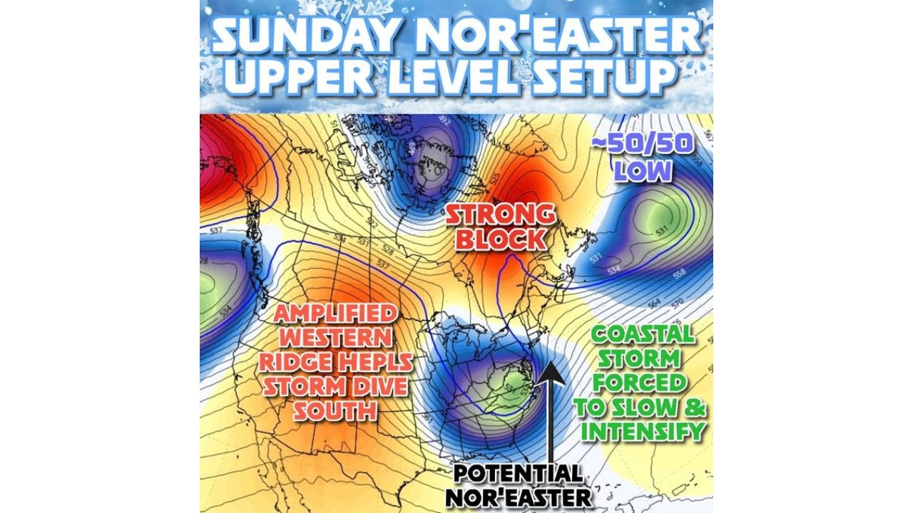
Meteorologists point to a combination of a strong northern block, a 50/50 low near eastern Canada, and an amplified western ridge as key features that could force a coastal system to slow, strengthen, and track favorably for snow across parts of the Northeast.
Strong Atmospheric Blocking Sets the Stage
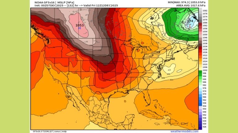
Forecast maps highlight a pronounced blocking pattern over eastern Canada, often referred to as a “strong block.” Blocking systems prevent storms from quickly escaping out to sea, instead forcing them to slow down and sometimes intensify.
This block, combined with a nearby 50/50 low — a semi-permanent low-pressure feature near 50°N latitude and 50°W longitude — creates a traffic jam in the upper atmosphere. When this happens, storms approaching the East Coast can be redirected and amplified.
For residents across New York, Massachusetts, Connecticut, and Pennsylvania, this blocking setup increases the likelihood that a coastal storm could linger rather than quickly move offshore.
Amplified Western Ridge Helps Storm Dive South
At the same time, an amplified western ridge across the western United States is helping to carve out a trough over the eastern half of the country. This configuration supports colder air funneling into the Northeast ahead of the storm.
The ridge-trough alignment effectively forces the developing system to dive south before turning up the coast — a classic Nor’easter pathway.
Cold air availability is a crucial factor. With colder air already in place, snowfall becomes more likely if the coastal storm intensifies and tracks close enough to the shoreline.
Coastal Storm Forced to Slow and Intensify
The current upper-level pattern suggests the coastal system may be forced to slow and intensify as it encounters the blocking high and the 50/50 low. Slower storms often produce heavier precipitation totals because they linger over a region longer.
If the storm consolidates near the Mid-Atlantic coast before lifting northeastward, snow could develop across Pennsylvania, New York City, Boston, and interior New England.
However, timing and exact positioning remain critical. A slight shift east would reduce impacts. A track closer to the coast would increase snowfall potential for densely populated areas.
Model Support Exists — But Uncertainty Remains
Forecasters acknowledge that recent storms have suffered from model inconsistencies. While the broader meteorological support appears solid, individual forecast runs still vary on storm strength and placement.
The presence of strong blocking and jet stream alignment is encouraging for snow lovers, but precise totals cannot yet be pinned down. Meteorologists stress that beyond three days, snowfall maps should be viewed as trend indicators rather than firm predictions.
The key takeaway is that the ingredients are in place: cold air, atmospheric blocking, and upper-level support. What remains uncertain is the exact interaction timing and final storm track.
What Residents Should Watch This Weekend
Communities across New York, Massachusetts, Pennsylvania, New Jersey, and Connecticut should monitor:
- Whether the storm consolidates along the coast
- How strong the blocking pattern remains
- The exact placement of the 50/50 low
- Snow-to-rain line positioning
Sunday into early Monday appears to be the primary window for potential impacts.
While it is too early to confirm snowfall totals, the overall setup has more structural support than previous failed systems this winter. That alone makes this Nor’easter threat one worth close attention.
As the Northeast watches this evolving pattern, ChicagoMusicGuide.com will continue tracking developments in the days ahead. For detailed winter weather analysis, storm updates, and regional forecast coverage, visit ChicagoMusicGuide.com.