North Dakota, Minnesota and South Dakota Brace for Heavy Snow and Ice as Northern Plains Storm Intensifies Through Thursday
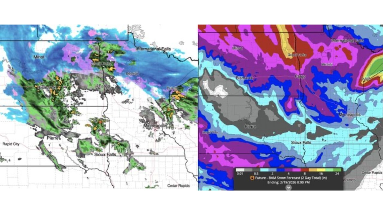
FARGO, NORTH DAKOTA — A powerful winter system is unfolding across the Northern Plains, bringing heavy snow accumulations and areas of ice to parts of North Dakota, northern Minnesota, and northeastern South Dakota through Thursday evening. Radar and snowfall projections show a strengthening storm spreading widespread precipitation from western North Dakota eastward into Minnesota.
Forecasters indicate that this system will continue producing accumulating snow for some locations into Thursday, with localized heavier bands developing under persistent lift.
Snow Expands from Western North Dakota into Minnesota
Current radar imagery shows widespread precipitation across Minot, Bismarck, and Grand Forks, with snow intensifying across eastern North Dakota into Fargo. The system extends southeast toward Sioux Falls, South Dakota, and into portions of central Minnesota.
Heavier snow bands appear most concentrated from Grand Forks northward toward International Falls, Minnesota, where deep moisture and colder air overlap. This corridor is expected to see some of the highest totals as the storm matures.
In contrast, parts of central South Dakota near Pierre and southwestern North Dakota are seeing lighter precipitation or mixed conditions, though snow continues to expand eastward.
Heaviest Totals Target Northern North Dakota and Northern Minnesota
Snowfall projections indicate the highest accumulations centered over northern North Dakota into northern Minnesota. The most intense zone stretches from Grand Forks through the Red River Valley and into International Falls.
Forecast totals suggest a broad swath of significant snow across this region, with darker shading on accumulation maps signaling the potential for heavier totals through Thursday evening.
Meanwhile, southern zones including Sioux Falls and Minneapolis appear positioned for moderate snowfall amounts, though totals decrease farther south into Iowa.
Ice Risk and Mixed Precipitation Add Travel Concerns
In addition to heavy snow, parts of the storm system are producing areas of mixed precipitation and light icing, particularly near transitional zones between heavier snow bands and warmer air intrusions.
This mix raises concerns for hazardous road conditions, especially along major corridors connecting Fargo, Minneapolis, and Sioux Falls.
As colder air remains entrenched across northern areas, most precipitation will fall as snow. However, brief periods of sleet or freezing rain cannot be ruled out along southern edges of the storm.
Storm Continues Through Thursday Evening
Forecast models show snow continuing into Thursday evening before gradually tapering off from west to east. Lingering snow bands may persist across Minnesota and northern Wisconsin late in the event.
Wind speeds, while not extreme, may be sufficient to cause blowing and drifting snow in open rural areas, particularly across eastern North Dakota.
Travel disruptions are likely in areas experiencing heavier snowfall rates, especially during peak accumulation periods.
What Residents Should Expect
Communities across North Dakota, northern Minnesota, and northeastern South Dakota should prepare for:
- Periods of moderate to heavy snowfall
- Reduced visibility during heavier bursts
- Slippery roads and difficult travel
- Localized icing in transitional zones
The most significant impacts appear focused on the Red River Valley region and northern Minnesota communities.
As the Northern Plains storm continues evolving, ChicagoMusicGuide.com will provide ongoing updates on snowfall trends and regional weather impacts. For continued winter storm coverage and forecast analysis, visit ChicagoMusicGuide.com.