Maryland, Pennsylvania, New Jersey and New York Enter 5-Day Window as Sunday–Monday Snowstorm Confidence Surges
BALTIMORE, MARYLAND — A potential Sunday night into Monday snowstorm is now within the critical five-day forecast window, and confidence is rapidly increasing that parts of the Mid-Atlantic and Northeast will see accumulating snow. While exact snowfall totals and track specifics remain unclear, meteorologists say the large-scale pattern strongly supports a winter storm somewhere between Maryland, Pennsylvania, New Jersey, and New York.
Forecasters emphasize that while a storm is highly likely, the finer details — including who sees the heaviest snow — are still being resolved.
Storm Confidence High — Details Still Uncertain
The overall setup features a classic Miller B coastal development, where an inland system transfers energy to a strengthening coastal low. This type of evolution often favors significant snow in the Mid-Atlantic and Northeast when conditions align.
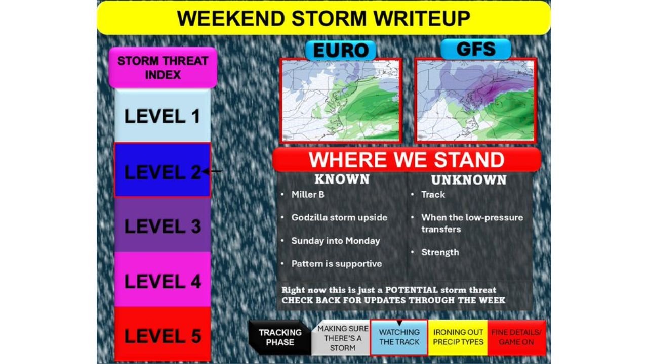
Forecast guidance from both the European (EURO) model and the GFS model shows broad agreement that a storm will develop and bring precipitation into the region Sunday into Monday.
However, the biggest unknown remains the storm’s exact track, which will determine the placement of heavy snow bands and rain-to-snow transition zones.
Supportive Pattern Signals Strong Potential
Meteorologists point to a supportive upper-level pattern that includes favorable jet stream alignment and a storm track capable of intensifying near the coast.
The current threat level sits around Level 2 on the Storm Threat Index, indicating a meaningful potential event but not yet locked into higher impact categories.
Forecasters describe the setup as having significant upside if all ingredients phase correctly. In some scenarios, rapid intensification near the coast could lead to heavier snowfall across interior Pennsylvania and New York, while coastal areas from New Jersey to Maryland would hinge on precise temperature profiles.
Known Factors vs. Remaining Questions
As the system enters the five-day range, several aspects are becoming clearer.
What is known:
- Storm development is highly likely
- Sunday into Monday is the primary impact window
- The large-scale atmospheric pattern is supportive
- Coastal development is expected
What remains uncertain:
- Exact storm track
- Timing of low-pressure transfer
- Storm strength
- Rain vs. snow line placement
Even small shifts of 50–75 miles could dramatically change snowfall totals for major metro areas including Baltimore, Philadelphia, New York City, and Boston.
Why Forecasters Urge Patience
While confidence in the existence of a storm is high, experts caution against focusing on early snowfall maps. Model depictions beyond three days frequently fluctuate, especially in dynamic coastal systems.
The next 48–72 hours will be critical in refining track and intensity details. Once the storm moves within the three-day window, confidence in snowfall projections should increase significantly.
At this stage, the forecast remains in the “tracking phase” — watching model trends, ironing out precipitation types, and awaiting fine details before declaring a final impact zone.
What Residents Should Do Now
Communities across Maryland, Pennsylvania, New Jersey, and New York should monitor forecast updates throughout the week. While it is premature to alter plans, the potential for impactful snowfall appears increasingly plausible.
If current trends continue, confidence may rise quickly as the weekend approaches.
ChicagoMusicGuide.com will continue providing in-depth coverage of this developing winter storm, including updates on track adjustments, snowfall projections, and regional impacts. For the latest Mid-Atlantic and Northeast weather analysis, visit ChicagoMusicGuide.com.