Washington, D.C., Maryland and Northern Virginia Face High-Uncertainty Sunday Snow Threat as Coastal Low Track Remains in Question
WASHINGTON, D.C. — An evolving coastal storm setup continues to keep Washington, D.C., Maryland, and Northern Virginia in the conversation for possible Sunday snow, but confidence in meaningful accumulation remains low as of midweek.
Forecast guidance has not changed significantly from earlier projections. While some models still signal the potential for accumulating snow, others — including the typically reliable European model — show little to no accumulation across the D.C. metro area. For now, anything from conversational snowflakes to several inches remains technically on the table.
Coastal Low Development Near the Carolinas Will Decide the Outcome
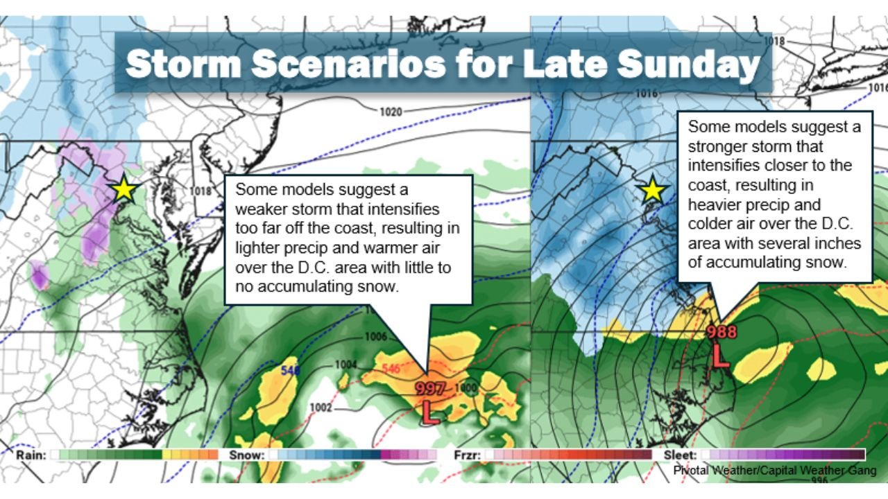
The key player in this setup is a developing low-pressure system expected to form near the Carolina coast early Sunday. What happens after that will determine whether the D.C. region sees impactful snow or mostly rain.
Two primary scenarios remain in play:
- A stronger, closer-to-coast track, which would intensify precipitation over the Mid-Atlantic and potentially cool the lower atmosphere enough for accumulating snow across Washington, D.C., and surrounding suburbs.
- A weaker or farther offshore track, which would keep precipitation lighter and allow warmer air to dominate, resulting in mainly rain with minimal snow accumulation.
The difference between these outcomes hinges on how quickly the storm strengthens and how close it tracks to the coastline.
Timing Suggests Late Sunday Is the Better Window
Even in the snowier scenarios, the best chance for accumulating snow would likely arrive late Sunday afternoon or Sunday night. Earlier precipitation looks lighter and may fall with temperatures slightly above freezing, limiting accumulation primarily to grassy surfaces.
Ground temperatures and marginal air temperatures remain a limiting factor. For significant accumulation to occur, precipitation rates would need to be heavy enough to cool the boundary layer rapidly.
This type of setup is highly sensitive to small changes in track and intensity — meaning forecast adjustments are still very possible over the next 24–48 hours.
Model Disagreement Keeps Confidence Low
While some forecast models continue to hint at accumulating snow potential in the D.C., Baltimore, and Northern Virginia corridor, others remain unimpressed. The European guidance, often regarded as one of the stronger performers in winter setups, still shows limited snowfall totals.
Because the system is still several days out, forecasters caution against focusing on early snowfall maps circulating online. At this range, small shifts in storm track can dramatically change outcomes.
As of now, confidence in impactful snow for the D.C. area remains too low to alter weekend plans.
A Classic Mid-Atlantic Wait-and-See Setup
Coastal winter storms in the Mid-Atlantic are notoriously sensitive to track and intensity. A slight jog west could dramatically increase snow totals, while a shift east could leave the region with little more than cold rain.
For residents of Washington, D.C., Maryland, and Northern Virginia, the situation remains fluid. Forecast clarity is expected to improve within the next day or two as higher-resolution guidance refines the storm’s development near the Carolina coast.
Until then, this remains a classic wait-and-see scenario.
Stay with ChicagoMusicGuide.com for continued updates as confidence builds and the Sunday storm track becomes clearer.