East Coast Braces for Potential Winter Storm: Higher Snow Risk From Appalachians to Mid-Atlantic Sunday Into Monday as Forecast Uncertainty Grows
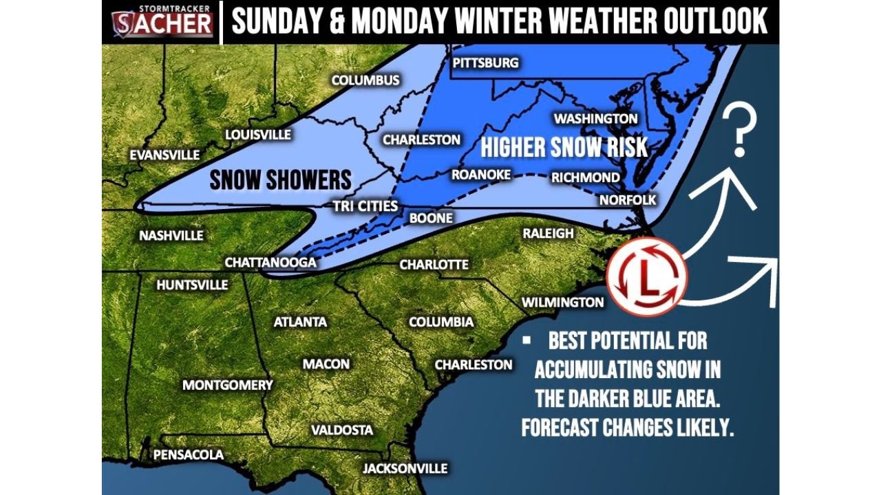
APPALACHIANS, UNITED STATES — Forecasters are closely monitoring the potential for a winter storm across the Eastern United States Sunday into Monday, with the greatest risk for accumulating snow currently focused on the Appalachians, Mid-Atlantic, and parts of the Northeast. While snowfall totals remain uncertain, meteorologists say there is a “high ceiling” for accumulation in select areas, meaning significant impacts are possible if the storm track aligns favorably.
Snow showers are also possible in the Tri-Cities region and neighboring Appalachian communities, especially late Sunday into Monday night, with light accumulations not ruled out. However, forecast adjustments are likely in the coming days.
Higher Snow Risk Centered From West Virginia to Virginia
The current outlook highlights the dark blue zone stretching from portions of West Virginia through western and central Virginia and into parts of the Mid-Atlantic as the area with the highest probability of accumulating snow. Cities including Charleston, Roanoke, Richmond, Washington, and Norfolk are within or near this higher-risk corridor.
Farther north, areas near Pittsburgh and parts of western Pennsylvania could also see measurable snowfall depending on how the storm evolves. Meteorologists caution that subtle shifts in the projected low-pressure system could dramatically alter totals across the region.
The system appears tied to a developing low-pressure center offshore, which may intensify and pull colder air southward into the Mid-Atlantic. That setup would favor accumulating snow in the higher elevations of the Appalachian Mountains, where colder surface temperatures are more likely to persist.
Snow Showers Possible in Tennessee and Kentucky Regions
Outside the primary accumulation zone, a lighter band of precipitation labeled as “snow showers” extends westward across parts of eastern Kentucky and northeastern Tennessee, including the Tri-Cities area, Boone, and surrounding Appalachian foothills.
Communities near Louisville, Columbus, and Charleston may see occasional snow showers, though widespread heavy accumulation appears less likely in those western areas at this time. Still, forecasters note that even light snowfall can create slick travel conditions during overnight hours.
For cities such as Nashville and Chattanooga, the system currently shows minimal risk for impactful snow, but colder air wrapping around the storm could still bring flurries or brief wintry bursts.
Forecast Uncertainty Remains High
Despite the defined risk zones, meteorologists emphasize that this forecast carries significant uncertainty. The exact placement of the storm’s track — particularly the strength and position of the offshore low — will determine whether snow bands expand farther south or shift northward toward the Northeast corridor.
The outlook specifically notes that forecast changes likely, underscoring the fluid nature of winter storm predictions several days in advance. Small shifts in temperature profiles could mean the difference between rain, mixed precipitation, or accumulating snow.
There is also the possibility of a higher snowfall ceiling in parts of the Appalachians and Mid-Atlantic if moisture and cold air align at peak intensity Sunday night into Monday morning. Conversely, if warmer air intrudes aloft, snowfall totals could be reduced.
Timing: Sunday Into Monday
The potential winter storm window currently spans Sunday through Monday, with snow showers developing first in the western Appalachian region before expanding eastward. Heavier precipitation, if it materializes, would likely peak late Sunday night into early Monday across portions of Virginia, West Virginia, Maryland, and southern Pennsylvania.
By Monday afternoon, the system may begin lifting northeastward, shifting impacts toward the Northeast U.S. and coastal regions.
Travel impacts remain possible in higher elevation communities, particularly along major corridors that cross the Appalachian terrain.
What Residents Should Watch For
Residents across the Appalachians, Mid-Atlantic, and Northeast should monitor updated forecasts over the next several days. Key factors to watch include:
- Final track of the developing low-pressure system
- Surface temperature trends across Virginia and West Virginia
- Potential for heavier snow bands in the darker blue highlighted areas
- Any winter weather advisories or watches issued
While confidence is growing in at least some snow potential, the overall severity remains uncertain.
As winter weather threats begin to take shape across the Eastern United States, staying informed is critical. For continued updates on major weather systems, regional impacts, and forecast changes, visit ChicagoMusicGuide.com for comprehensive coverage.