NOAA Map Flags Heavy Snow and High Winds From Baltimore to Boston Feb 22–23 as Bomb Cyclone Potential Looms Along East Coast
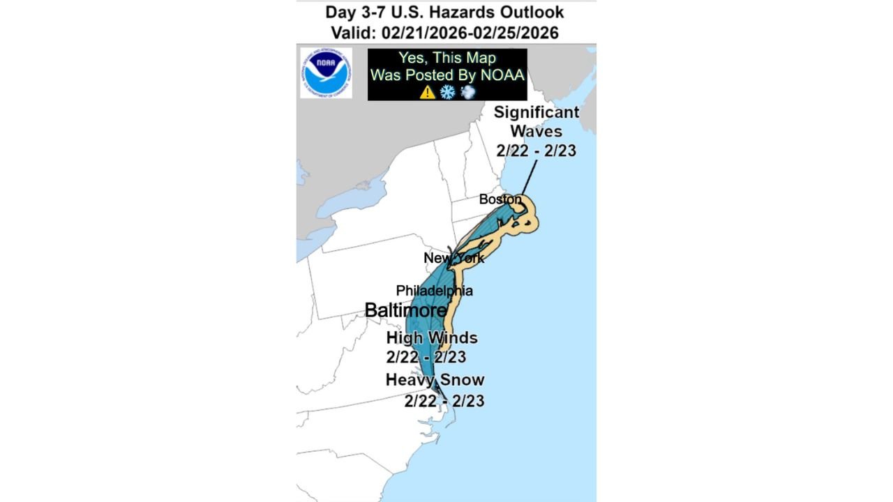
BALTIMORE, MARYLAND — A newly released NOAA Day 3–7 U.S. Hazards Outlook is highlighting a corridor of potential heavy snow and high winds from Baltimore north through Philadelphia, New York City, and up to Boston between February 22 and February 23, 2026. The map outlines a coastal zone where significant winter impacts could develop — but only if a rapidly strengthening storm system takes shape offshore.
Forecasters note that this threat hinges on the formation of a possible bomb cyclone, a rapidly intensifying coastal low-pressure system capable of producing heavy snowfall, damaging wind gusts, and hazardous marine conditions.
Cities From Baltimore to Boston Marked on NOAA Hazard Map
The NOAA outlook clearly outlines a coastal swath that includes:
- Baltimore, Maryland
- Philadelphia, Pennsylvania
- New York City, New York
- Boston, Massachusetts
Within this zone, the map highlights “Heavy Snow” and “High Winds” for February 22–23, while offshore waters show a separate area labeled for “Significant Waves” during the same period.
The placement of these hazard zones suggests the greatest impacts would be focused along the I-95 corridor, particularly in coastal and near-coastal communities.
Bomb Cyclone Development Is the Key Variable
The outlook specifically indicates that impacts depend on whether a bomb cyclone forms along the East Coast. A bomb cyclone occurs when a storm rapidly intensifies, typically deepening at least 24 millibars within 24 hours. When this happens near the coastline, strong pressure gradients can produce powerful winds while colder air wrapping into the system can generate heavy snowfall.
If the system strengthens offshore, cities such as Baltimore, Philadelphia, New York City, and Boston could experience accumulating snow combined with gusty winds — a combination that can reduce visibility and create hazardous travel conditions.
However, meteorologists caution that the phrase “potential” does not equal certainty. Small shifts in the storm’s track could move the heaviest precipitation farther offshore or closer inland.
High Winds and Coastal Impacts Also in Focus
In addition to snowfall concerns, the NOAA hazard map highlights the risk of high winds along the Mid-Atlantic coastline, particularly near Baltimore and areas southward toward coastal Maryland and Delaware.
Farther north, offshore waters near New England are marked for significant wave activity, signaling possible marine hazards and rough surf conditions if the system intensifies.
Should the low-pressure system deepen quickly, strong northeasterly winds could produce blowing snow in inland areas while generating coastal wave action and minor flooding in vulnerable shoreline communities.
Timing: February 22–23 Window
The hazard outlook covers February 21 through February 25, but the highlighted winter weather threat is specifically centered on February 22–23. That suggests the most significant impacts, if realized, would occur Sunday into Monday.
Because this remains a multi-day forecast window, adjustments are still expected as model guidance refines the projected storm track and strength.
Forecast Confidence Still Developing
While NOAA has identified this corridor as an area of concern, forecasters remain cautious. Rapid intensification scenarios are notoriously sensitive to subtle atmospheric changes.
If the storm fails to strengthen into a bomb cyclone, snowfall amounts and wind speeds could be significantly lower than currently depicted. Conversely, a stronger-than-expected system could expand impacts north and south of the highlighted zone.
Residents in Baltimore, Philadelphia, New York City, Boston, and surrounding coastal communities should monitor forecast updates closely over the coming days.
As winter storm potential grows along the East Coast, preparation and awareness remain essential. For continued coverage of major weather developments affecting cities across the United States, visit ChicagoMusicGuide.com for the latest updates and analysis.