Illinois and Indiana Placed Under Enhanced Risk as Storm Prediction Center Flags Strong Tornado Threat
SPRINGFIELD, ILLINOIS — The Storm Prediction Center (SPC) has upgraded portions of southeastern Illinois and western to central Indiana to an Enhanced Risk for severe weather, citing the potential for a strong tornado as supercells develop near a sharp moisture boundary.
The updated outlook highlights a corridor stretching from southeastern Illinois into Indiana, where atmospheric conditions appear increasingly supportive of rotating thunderstorms capable of producing damaging winds and tornadoes.
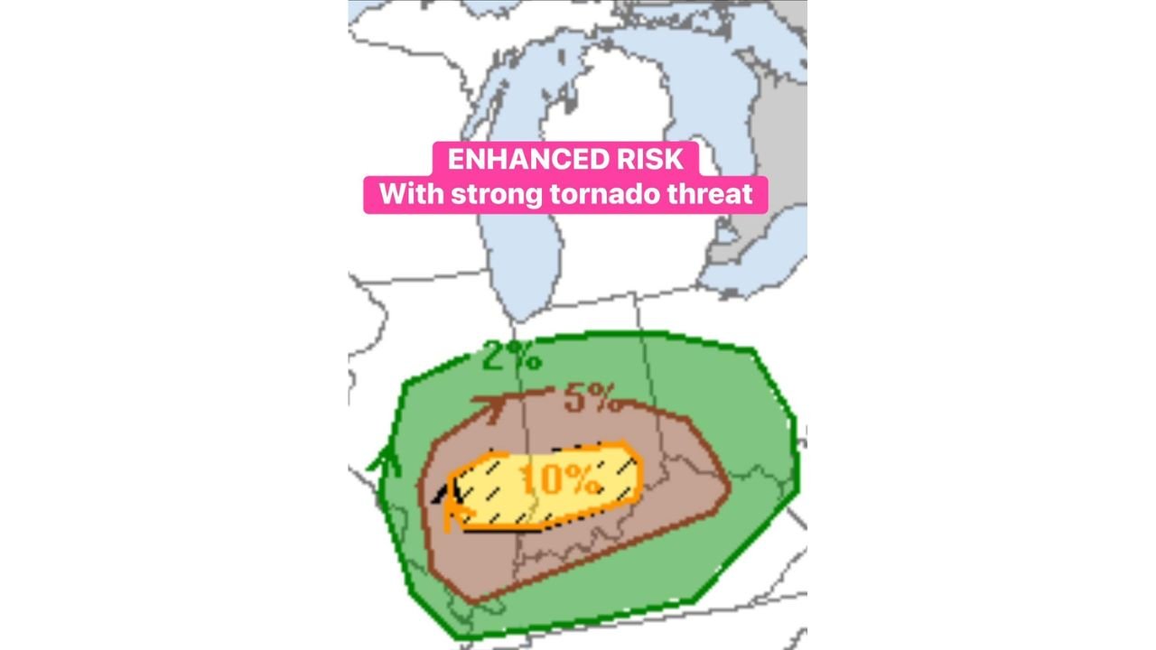
Enhanced Risk With 10% Tornado Zone
The SPC graphic shows a broad Enhanced Risk (Level 3 of 5) area covering much of southeastern Illinois into Indiana, surrounded by a larger Slight Risk region.
Within that Enhanced zone:
- A 5% tornado probability area extends across parts of Illinois and Indiana
- A more focused 10% hatched tornado zone signals potential for strong tornadoes (EF2 or greater)
The hatched area is especially significant. It indicates that if storms form in this corridor, environmental wind shear and instability could support stronger, longer-lived tornadoes.
Key Ingredients Coming Together
Forecasters point to several atmospheric factors increasing concern across southeastern Illinois and Indiana:
- 60°F dew points pushing northward
- A strong 50-knot low-level jet enhancing wind shear
- Supercells potentially forming along the northern edge of richer moisture
Any storm that tracks along that moisture boundary may have an increased chance of rotation. The juxtaposition of instability and strong low-level winds creates an environment favorable for tornadic development.
The northern edge of the moisture plume appears critical. Storms forming there may maximize low-level shear while maintaining sufficient instability.
Areas Most at Risk
Counties in southeastern Illinois and portions of western and central Indiana are positioned within the highest concern zone. Cities potentially impacted include:
- Effingham, Illinois
- Mattoon, Illinois
- Terre Haute, Indiana
- Bloomington, Indiana
- Indianapolis metro (southern sections)
While the Enhanced Risk area is not a guarantee of tornadoes, it reflects an elevated probability of severe storms capable of producing damaging wind, hail, and tornadoes.
Timing and Storm Mode
Storm development is expected during the afternoon into evening hours, particularly as instability increases ahead of the advancing system.
Supercell thunderstorms — discrete, rotating storms — are the primary concern. These types of storms are most capable of producing:
- Strong tornadoes
- Large hail
- Localized wind damage
The presence of a robust low-level jet suggests storms could maintain rotation into the evening if instability remains sufficient.
What Residents Should Do
With an Enhanced Risk and a 10% hatched tornado zone in place, residents in southeastern Illinois and Indiana should:
- Monitor updated forecasts and warnings
- Ensure weather alerts are enabled
- Identify safe shelter locations in advance
Tornado potential, especially strong tornado potential, requires quick action if warnings are issued.
As southeastern Illinois and Indiana move into a higher-tier severe weather category, the atmosphere is signaling that this is not a routine thunderstorm day. With strong wind shear and deep moisture in place, the setup bears watching closely. For continued severe weather updates and Midwest storm coverage, visit ChicagoMusicGuide.com.