New Jersey, New York, Connecticut and Massachusetts in the Main Target Zone as Sunday–Monday Winter Storm Threat Sharpens Across the Northeast
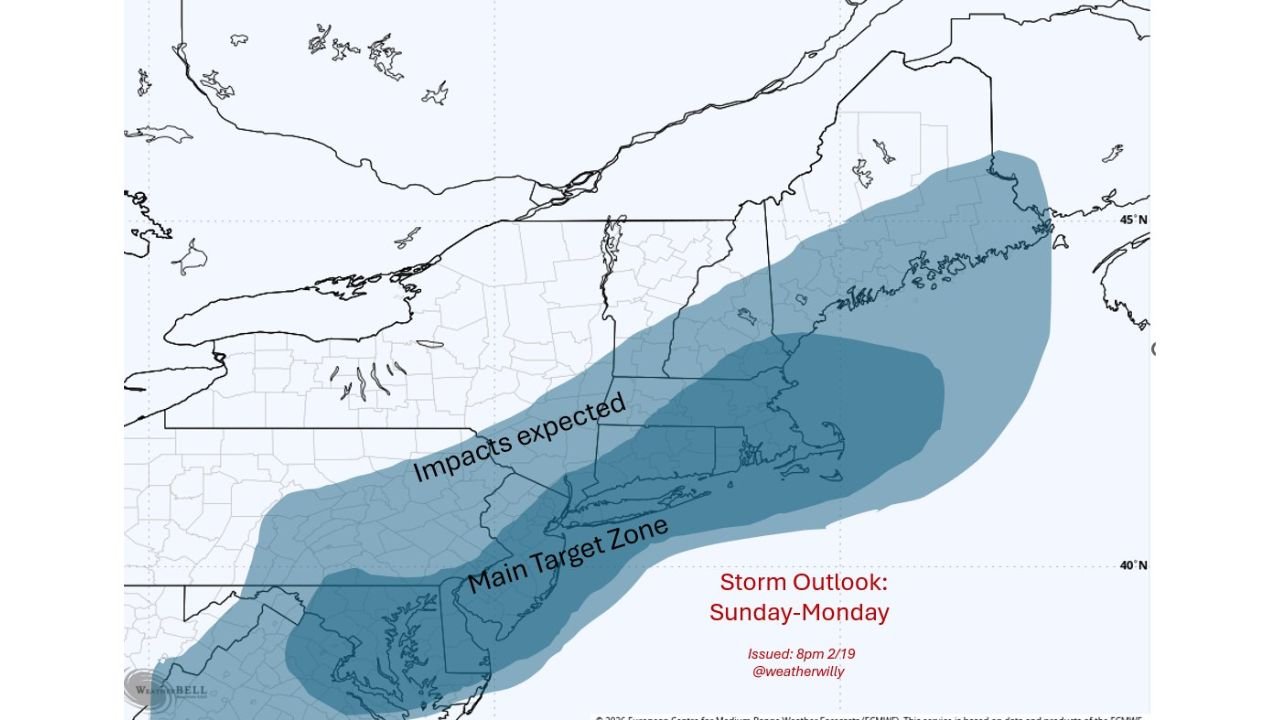
NEW JERSEY — A developing winter storm threat for Sunday into Monday is beginning to take clearer shape, with an early impact map placing New Jersey, southeastern New York, Connecticut, Rhode Island, and eastern Massachusetts in what is being labeled the “Main Target Zone.”
While final track and intensity details are still being refined, the projected swath of impacts stretches from the Mid-Atlantic coastline northeastward through southern New England, suggesting a potentially significant late-February snowfall event.
Main Target Zone: NJ to Eastern MA
The highlighted core impact area includes:
- Central and southern New Jersey
- New York City and Long Island
- Coastal and inland Connecticut
- Rhode Island
- Eastern Massachusetts, including the Boston metro
This zone appears most favored for steadier precipitation and stronger coastal dynamics if the system tracks as currently expected.
The impact shading broadens inland across:
- Eastern Pennsylvania
- The Hudson Valley
- Interior portions of Massachusetts
- Southern Vermont and New Hampshire
- Coastal and southern Maine
Impacts Expected Inland as Well
Beyond the main coastal corridor, impacts are expected across a larger diagonal swath from the Delmarva Peninsula through eastern Pennsylvania and into northern New England.
Cities potentially affected include:
- Philadelphia
- Newark
- New York City
- Bridgeport
- Providence
- Boston
- Portland, Maine
If the storm strengthens offshore, snowfall totals could increase rapidly along and just inland from the I-95 corridor.
Sunday Night: The Critical Period
Forecast guidance continues to identify Sunday night into early Monday morning as the primary window for:
- Heavier precipitation rates
- Stronger coastal winds
- Travel disruptions
This timing would impact both late weekend travel and the Monday morning commute across much of the Northeast.
What Will Decide Snowfall Totals
Several key factors remain in play:
- Exact storm track relative to the coastline
- Availability of cold air across inland areas
- Potential mixing near immediate coastal zones
- Strengthening of the low-pressure system offshore
A slight eastward shift could limit heavier totals inland, while a closer coastal track would enhance snowfall rates from New Jersey through Massachusetts.
Model Confidence Still Evolving
Forecasters are awaiting the latest overnight model runs to determine whether the current projection holds steady. The early impact map reflects a scenario in which snow spreads steadily northeast along the coast, with the heaviest axis centered over southern New England and the New York City metro region.
If upcoming data agrees, winter storm watches could follow as early as late Friday or Saturday.
What Residents Should Do Now
Residents across New Jersey, New York, Connecticut, Rhode Island, Massachusetts, Vermont, New Hampshire, and Maine should:
- Monitor updated forecasts
- Review travel plans for Sunday night and Monday
- Prepare for possible snow-covered roads and reduced visibility
While details are still being refined, the signal for a coastal winter system is becoming increasingly organized. The next 24–36 hours of model guidance will be critical in confirming whether this Sunday–Monday setup becomes a high-impact snow event across the Northeast.
ChicagoMusicGuide.com will continue tracking developments as confidence in the storm’s track and intensity improves.