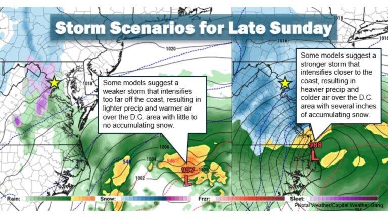
Virginia, North Carolina and New Jersey Back in Play as ECMWF Trend Shows Storm Track Shifting West Toward the East Coast
VIRGINIA — A notable westward adjustment in the latest European ensemble guidance is pulling the developing Sunday–Monday storm closer to the East Coast, potentially increasing impacts from North Carolina and Virginia through New Jersey and southern New England.
The shift, seen in recent Euro, AIFS, and ensemble trends, appears tied to deeper troughing over the eastern United States and a stronger atmospheric block near Atlantic Canada — a combination that can “back” storms toward the coastline rather than allowing them to slide harmlessly out to sea.
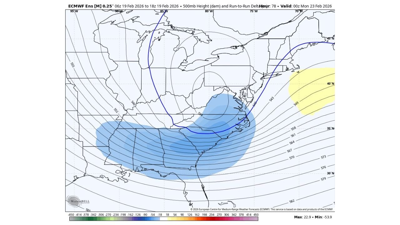
What Changed in the Upper-Level Pattern
The 500mb height analysis valid late Sunday night shows:
- A deeper trough digging into the Southeast and Mid-Atlantic
- Consolidated interaction between northern and southern stream energy
- A stronger 50/50 low near Atlantic Canada helping suppress heights offshore
This configuration tends to:
- Slow the storm’s eastward escape
- Tug the low-pressure system closer to the coast
- Enhance lift across the Mid-Atlantic and southern New England
In simple terms, the atmosphere may now favor a more coast-hugging track.
States That Benefit From a Westward Shift
If this trend holds, the following areas move closer to the core impact zone:
- Eastern North Carolina
- Coastal and central Virginia
- Maryland and Delaware
- New Jersey
- New York City and Long Island
- Southern Connecticut and Rhode Island
- Eastern Massachusetts
A westward nudge often means heavier precipitation potential shifting inland rather than staying offshore.
Why the 50/50 Low Matters
A stronger 50/50 low — positioned near Atlantic Canada — acts as a block. By pumping heights north of the storm, it prevents the system from escaping too far east.
This can:
- Force the storm closer to the coast
- Increase precipitation coverage inland
- Support stronger coastal cyclogenesis
That blocking setup is one reason forecasters are taking the westward model trend seriously.
Deeper Troughing Adds Lift
The deeper trough shown digging across the Southeast enhances upper-level divergence. That added energy helps intensify surface low pressure near the coast.
If northern and southern stream energy phases effectively:
- The storm could strengthen more quickly
- Precipitation bands could expand northwest
- Impacts could spread farther inland
The degree of consolidation between those streams will be crucial over the next 24 hours of model runs.
What This Means for Sunday–Monday
With this westward adjustment, Sunday night into Monday remains the primary window for potential impacts across the Mid-Atlantic and Northeast.
Possible outcomes include:
- Heavier precipitation totals closer to I-95
- Stronger winds along the coast
- Expanded impact zone into interior sections
However, small track changes still matter. A 50–100 mile shift east or west could dramatically alter which metro areas see the heaviest impacts.
Still Waiting on Final Confirmation
Forecasters are now turning to the next 00z model cycle to see whether this westward trend continues or corrects back east.
Confidence is increasing in a more amplified pattern, but final storm positioning is not yet locked in.
Residents from North Carolina through Virginia, Maryland, New Jersey, New York, and southern New England should continue monitoring updates as the atmospheric puzzle pieces come together.
ChicagoMusicGuide.com will continue tracking the evolving upper-level pattern and storm track as we approach the Sunday–Monday timeframe.