New York, New Jersey, Pennsylvania and Massachusetts Brace for Possible Nor’easter Blizzard as Models Clash Over Major Snowstorm
NEW YORK CITY, NEW YORK — A late-weekend Nor’easter threat is gaining attention across the Northeast, but the bigger story right now is the unusually wide spread in forecast guidance. Within the typical 3–5 day window, leading models are painting sharply different outcomes—from a major Mid-Atlantic blizzard scenario to a more modest New England winter storm with the heaviest snow possibly staying offshore.
What The Models Are Saying: GFS vs Euro vs Canadian vs NAM
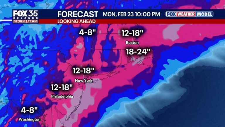
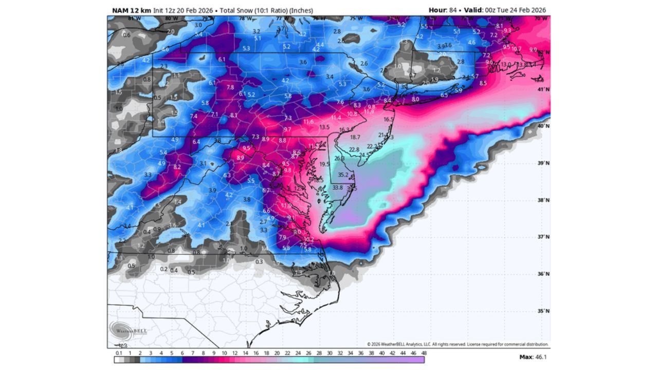
The current guidance shows one of those classic “same storm, different worlds” setups. The GFS has repeatedly suggested a high-end outcome focused on the Mid-Atlantic, with a broad swath of heavy snow stretching through parts of Virginia, Maryland, Delaware, Pennsylvania, New Jersey, and into the New York City metro. In that solution, the I-95 corridor becomes a prime disruption zone, with several areas flirting with double-digit totals and impactful wind-driven conditions.
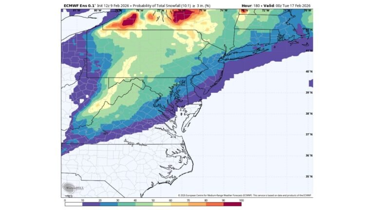
On the other end, the ECMWF (Euro) leans toward a more restrained outcome for the Mid-Atlantic, keeping the storm’s most intense precipitation farther east and pushing the most significant snow signal closer to or even offshore of New England. That would reduce totals for cities like Washington, D.C., Baltimore, and Philadelphia, while still leaving room for a plowable event in parts of New York and southern New England, depending on the final track.
The Canadian (GEM/GDPS) sits between those extremes, showing a storm that still produces meaningful snow but doesn’t necessarily deliver the “historic” footprint implied by the most aggressive GFS runs. Meanwhile, the NAM—often dramatic in certain setups—shows a powerful storm look on some guidance, but at this range its swings are less useful for locking in specific totals. The takeaway: deterministic maps are not a promise right now; they’re a snapshot of uncertainty.
Where The Highest Snow Risk Sets Up If The Track Shifts West or East
This is the kind of forecast where a small change in storm evolution can completely rearrange the snowfall map. If the storm track trends even slightly west, the heavier snow axis can push into the Mid-Atlantic and up through New Jersey toward New York City. That scenario raises the ceiling for widespread 8–12 inches with localized higher pockets, especially where banding sets up.
If the track shifts east, the biggest totals can slide toward coastal New England and even offshore, leaving much of the Mid-Atlantic with lighter accumulations or a sharper cutoff. In that case, cities such as Boston, Providence, and areas across Rhode Island, eastern Massachusetts, and parts of Connecticut (including the Hartford region) become more sensitive to where the deformation band and ocean influence land.
In either scenario, the corridor from Philadelphia to New York City to southern New England remains the zone to watch most closely. The maps also highlight how quickly totals can change across short distances—one county gets heavy snow, the next gets far less—especially when coastal fronts and temperature profiles are involved.
Why Confidence Is Low Right Now and What Forecasters Watch Next
When models disagree this strongly, it usually comes down to a few key ingredients: how the southern energy ejects, where the storm consolidates, how quickly it intensifies, and whether it tucks closer to the coast or deepens farther offshore. Another major factor is the temperature structure near the coast—small differences can decide whether precipitation falls as heavy wet snow, mixed precipitation, or primarily rain in the most coastal spots.
Over the next 24–48 hours, a few signals can tighten the forecast:
- Whether model trends converge on a consistent storm track near the Delmarva, New Jersey, and Long Island corridor
- Signs of stronger coastal cyclogenesis (rapid strengthening) that would increase wind and enhance snowfall bands
- Improved agreement on where the heaviest snow band sets up from the Mid-Atlantic into southern New England
- Better clarity on wind potential that could create near-blizzard visibility in heavier snow bursts
Until those pieces come into focus, it’s smart to avoid attaching to one single model’s snow map. The best way to treat this setup is as a developing threat where impacts could range from a routine winter storm to a high-impact event depending on track and intensity.
What This Means For Travel, Shows, and Weekend Plans Across The Northeast
If you’re traveling for concerts, venues, or weekend events anywhere from Washington, D.C. through Philadelphia, New York City, Hartford, and up toward Boston, plan for potential disruption even before totals are finalized. A storm timed Sunday into Monday can hit at the worst possible window for return travel, flights, and commuter schedules.
Here are practical steps that match the current uncertainty:
- Keep travel plans flexible, especially if you’re using airports serving NYC, Boston, or Philadelphia
- Expect delays on major roadways like I-95 if heavier banding develops
- If attending a show, watch for venue updates in case weather affects staffing, transit, or touring logistics
- Charge devices, stock basics, and prepare for slower travel if heavier snow and wind overlap
The model split doesn’t mean “nothing will happen.” It means the forecast ceiling and floor are far apart—and the region could shift from moderate snow to significant totals quickly as guidance tightens.
For more storm coverage and weather-driven event updates for music fans, keep checking ChicagoMusicGuide.com as the Nor’easter forecast becomes clearer and impacts come into sharper focus.