Delaware, Maryland, Pennsylvania and New Jersey Face Rain-to-Snow Nor’easter Sunday Night as Coastal Track Could Decide Who Sees the Most Snow
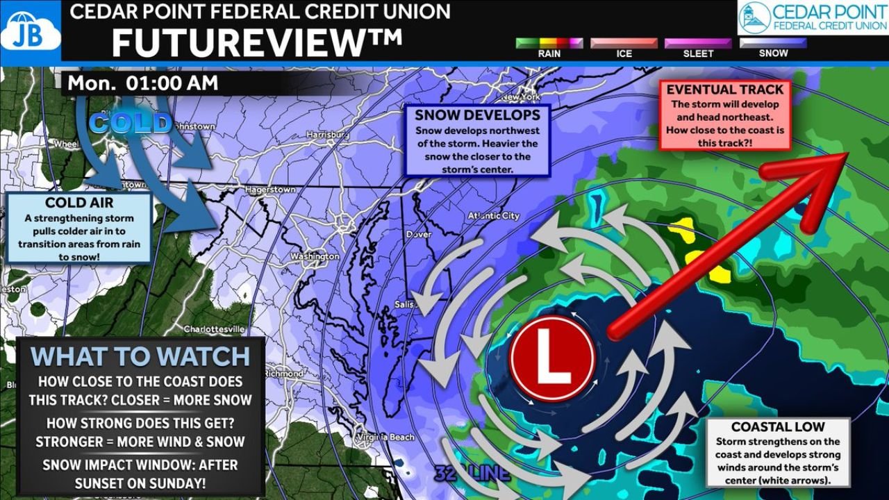
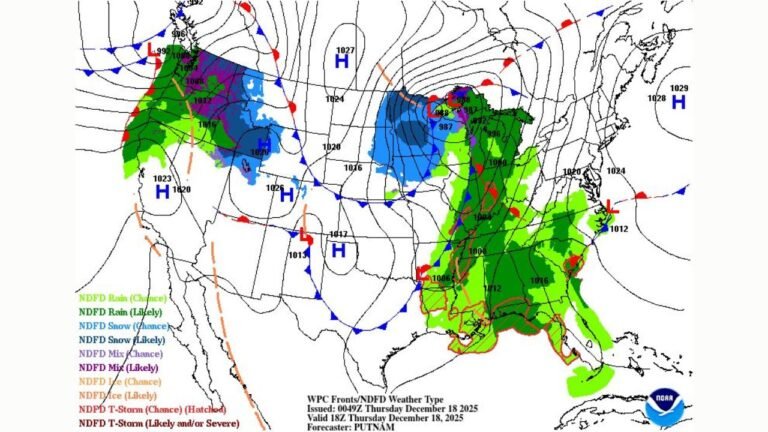
PHILADELPHIA, PENNSYLVANIA — A strengthening coastal low pressure system is expected to impact Delaware, Maryland, Pennsylvania, and New Jersey beginning Sunday afternoon with rain before transitioning to snow Sunday evening as colder air presses in from the northwest. Forecasters say the exact storm track along the coastline will determine which communities see heavier snow and stronger winds overnight into Monday.
The evolving setup shows rain developing for most areas after lunchtime Sunday. As the storm strengthens offshore, colder air will wrap into the system, allowing precipitation to transition from rain to snow around or shortly after sunset.
Rain Transitions to Snow as Cold Air Moves In
Model guidance suggests the storm will intensify near the coast Sunday night. As that happens, colder air will be pulled into the circulation from inland Pennsylvania and western Maryland. That process allows rain to change to snow across much of eastern Pennsylvania, New Jersey, Delaware, and portions of Maryland.
The rain-to-snow line will likely push southeast through the evening. Areas northwest of the storm center typically see the heaviest snow, meaning inland zones could quickly flip from wet roads to accumulating snow during prime evening hours.
The key timing window for accumulating snow appears to be after sunset Sunday through early Monday morning.
Delmarva and Areas East of Philadelphia Most Favored for Heavier Snow
Current projections indicate that communities along the Delmarva Peninsula and areas east of Philadelphia are in a favored zone for higher snowfall totals. Being closer to the eventual coastal track increases the likelihood of stronger lift and more persistent snow bands.
Forecasters note that some areas could approach up to a foot of snow if the storm tracks close enough to the coastline and strengthens rapidly. Meanwhile, totals around 3–6 inches appear more likely along and east of the I-95 corridor, though this could increase with even minor westward adjustments in the storm path.
The exact placement of the heaviest snow band remains uncertain, and a shift of 30–50 miles could dramatically change totals for cities such as Philadelphia, Wilmington, Atlantic City, and surrounding suburbs.
Storm Track and Strength Will Determine Final Impacts
Two main variables will shape the final outcome:
- How close the storm tracks to the coastline
- How quickly the coastal low intensifies Sunday night
A closer and stronger track would enhance snowfall totals farther inland, increase wind speeds, and prolong the snow window. A weaker or more offshore path would limit snowfall amounts and shorten the duration of accumulation.
Even small shifts over the next 24–36 hours could significantly adjust snowfall expectations. That’s why confidence remains moderate, and forecasters emphasize that this is still an evolving setup.
Travel Could Deteriorate Rapidly Sunday Evening
If the rain-to-snow transition occurs as expected, road conditions could worsen quickly Sunday evening. Wet surfaces may freeze as colder air deepens, especially inland from the coast.
Potential impacts include:
- Slippery highways along I-95, I-295, and I-476
- Reduced visibility in heavier snow bands
- Gusty winds near the coast if the low strengthens
- Delays for flights and regional transit systems
Communities in Delaware, southeastern Pennsylvania, southern New Jersey, and eastern Maryland should monitor updates closely, as snowfall totals may shift with new model data.
What to Watch Over the Next 24 Hours
Forecasters are closely monitoring:
- Placement of the developing coastal low
- Timing of the rain-to-snow changeover
- Strength of cold air intrusion from the northwest
- Development of narrow heavy snow bands near the storm center
This is not an easy forecast, and confidence in exact totals remains lower than usual at this stage. However, the ingredients are in place for a meaningful winter event if the coastal track aligns favorably.
For continued updates on this developing Nor’easter, including how snow and travel disruptions could affect concerts and events across the Mid-Atlantic and Northeast, keep checking back with ChicagoMusicGuide.com.