Washington, D.C., Maryland and Northern Virginia Winter Storm Forecast: 1–6 Inches Likely With Wide Range of Outcomes Sunday Into Monday
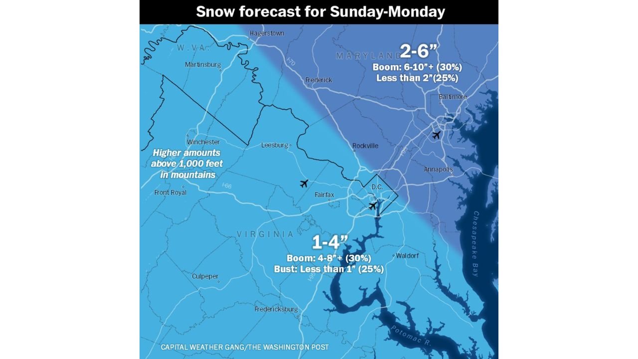
WASHINGTON, D.C. — A developing Sunday into Monday winter storm is prompting a first-call snowfall forecast across Washington, D.C., Maryland, and northern Virginia, but forecasters stress that uncertainty remains higher than usual. Current projections show 1–4 inches for much of northern Virginia and the DC metro, and 2–6 inches across Maryland, with the potential for localized higher totals if the storm strengthens or shifts slightly.
Officials caution that this forecast will likely be refined before the weekend, and residents should continue monitoring updates as the storm track evolves.
Snowfall Forecast for Washington, D.C., Maryland and Northern Virginia
The early snowfall map highlights a clear gradient from southwest to northeast:
- 1–4 inches across much of northern Virginia, including areas near Fairfax, Fredericksburg, and Culpeper
- 2–6 inches across central and northern Maryland, including communities near Frederick and Baltimore’s northern suburbs
- Slightly higher amounts possible in mountain areas above 1,000 feet elevation, particularly west toward Winchester and the higher terrain of western Maryland and West Virginia
For the DC metro area, the current call leans toward the lower-to-middle range of that 1–4 inch projection. However, there is still a chance of higher totals if the storm trends stronger or tracks slightly closer to the coast.
Why There Is More Uncertainty Than Usual
Forecasters note that snowfall ranges are broader than typical because confidence in the exact storm evolution is lower than normal at this stage. The storm’s path, intensity, and timing of colder air will determine how much snow ultimately accumulates.
There are three main possibilities reflected in the forecast:
- A moderate scenario delivering the projected 1–4 inches in DC and northern Virginia
- A stronger outcome where parts of Maryland could “boom” into the 6–10 inch range (roughly a 30% chance)
- A weaker scenario where some areas receive less than 1–2 inches (around a 25% chance)
Small changes in storm strength or track over the next 24–48 hours could quickly shift totals upward or downward.
Wet Snow Likely Sunday Before Better Accumulation at Night
One key factor in this setup is temperature. Forecasters expect wet snow to fall for much of Sunday, especially during daylight hours. Because ground temperatures may still be relatively mild, early accumulation could mainly occur on grassy surfaces.
Road accumulation is more likely to hold off until closer to nightfall Sunday, when colder air deepens and the storm intensifies. That timing means conditions could worsen Sunday evening and overnight into early Monday morning.
Higher Elevations Could See Greater Totals
Areas above 1,000 feet elevation—particularly in the mountains west of the DC metro—are more likely to see higher totals. Colder air in those regions will support steadier snow accumulation compared to lower elevations closer to the Chesapeake Bay.
Communities in western Maryland and parts of northern Virginia’s higher terrain should monitor updated forecasts carefully, as they sit in a zone where totals could exceed the base range.
What to Watch Before the Final Forecast Update
Forecasters plan to refine the snowfall map ahead of the storm, with updated guidance expected before Sunday. Key elements to watch include:
- How quickly colder air presses in from the northwest
- Whether the coastal low strengthens more aggressively
- The exact placement of the rain-to-snow transition line
- Potential for heavier banding overnight Sunday
Given the fluid nature of this forecast, preparation is recommended even though totals remain uncertain.
Residents across Washington, D.C., Maryland, and northern Virginia should prepare for at least minor travel disruptions Sunday night, with the possibility of more significant impacts if snowfall trends higher.
For continued coverage of this developing winter storm and updates on potential travel and event impacts across the region, stay connected with ChicagoMusicGuide.com.