New York, New Jersey, Connecticut and Massachusetts Brace for Major I-95 Blizzard Threat With 12–24 Inches Possible From Philadelphia to Boston
NEW YORK, NEW YORK — A powerful Sunday night into Monday snowstorm is targeting the major I-95 corridor cities, including Philadelphia, New York City, Hartford, and Boston, with forecast models now aligning on the potential for 12 inches or more of snowfall across large portions of Delaware, New Jersey, Connecticut, and eastern Massachusetts. Coastal areas could also see 50–75 MPH wind gusts, raising the risk of near-blizzard conditions and significant air-travel disruptions nationwide.
Forecast guidance shows the storm intensifying rapidly as it tracks northeast along the coastline, placing some of the most densely populated cities in the country directly in its path.
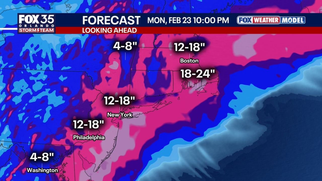
12–24 Inches Possible From Philadelphia to Boston
Current model projections highlight a broad swath of 12–18 inches from Philadelphia through New York City and into interior southern New England. Farther north and east, especially around Boston and eastern Massachusetts, totals could climb into the 18–24 inch range if the storm strengthens as expected.
Key projected snowfall ranges include:
- Philadelphia, Pennsylvania: Around 12–18 inches
- New York City, New York: Approximately 12–18 inches
- Hartford, Connecticut: Roughly 8–12 inches, with higher amounts possible nearby
- Boston, Massachusetts: Between 18–24 inches, particularly in eastern sections
Meanwhile, Washington, D.C. may sit on the southern edge of the heaviest banding, with forecasts indicating around 4–8 inches, depending on the final storm track.
The alignment between multiple forecast models suggests increasing confidence in a high-impact event, especially across the New York metropolitan area and southern New England.
Blizzard-Level Winds Along the Coast
Beyond snowfall totals, wind will be a major factor. Coastal regions from New Jersey’s shoreline through eastern Massachusetts could experience 50–75 MPH gusts, strong enough to create whiteout conditions, coastal blowing snow, and possible power outages.
These wind speeds combined with heavy snowfall could meet criteria for localized blizzard conditions, particularly in exposed coastal areas. Reduced visibility, drifting snow, and hazardous travel are expected during the height of the storm late Sunday into Monday.
Airports in New York City, Newark, Boston, and Philadelphia may face significant delays or cancellations, with ripple effects expected across the national air-travel network.
Jackpot Zones Emerging in Eastern Massachusetts and the Jersey Shore
Forecast maps highlight eastern Massachusetts and portions of the Jersey Shore as early “jackpot” candidates, where banding could push snowfall totals toward or beyond the upper end of projections.
If heavier snow bands stall over these regions, localized totals could exceed two feet, particularly east of Boston and along coastal Massachusetts.
Interior areas of Connecticut and upstate New York may also see substantial snowfall, though exact totals will depend on the storm’s final track and temperature profile.
Timing: Sunday Night Through Monday Evening
Snow is expected to intensify Sunday evening, with the heaviest impacts overnight into early Monday. Coastal winds are likely to peak during this same period, compounding travel hazards.
Monday morning commutes across New York, New Jersey, Connecticut, and Massachusetts could be severely impacted, especially if snowfall rates exceed one to two inches per hour during peak banding.
Forecasters stress that final totals may still shift slightly depending on the storm’s exact path, but confidence is increasing that this will be a significant winter event for the Northeast.
Residents across the I-95 corridor should prepare for potential power outages, hazardous travel conditions, and school or business disruptions early next week.
For continued updates on this developing Northeast winter storm and its broader travel and event impacts, stay connected with ChicagoMusicGuide.com for the latest weather coverage.