Pennsylvania, New Jersey and New York Face Major East Coast Blizzard Threat With 12–24 Inches Possible From Philadelphia to Long Island
HARRISBURG, PENNSYLVANIA — First-call snow maps are signaling a potentially high-impact East Coast blizzard from Pennsylvania through New Jersey and into New York, with forecasters expressing strong confidence that areas east of Interstate 81 in Pennsylvania could see significant snowfall. Projections show a powerful coastal low riding northward from Virginia to Maine, delivering widespread heavy snow and possible blizzard conditions along the coast Sunday into Monday.
Meteorologists caution that residents, particularly in eastern Pennsylvania and along the I-95 corridor, should prepare early for potential power outages and dangerous travel conditions.
12–18 Inches Across Eastern Pennsylvania and New Jersey
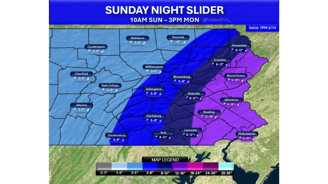
The latest forecast maps place a large portion of eastern Pennsylvania and central to northern New Jersey in a 12–18 inch snowfall zone. Cities including:
- Philadelphia, PA: 12–18 inches
- Reading, PA: 12–18 inches
- Allentown, PA: 12–18 inches
- Lancaster, PA: 8–12+ inches
- York, PA: 8–12 inches
Further north and west across central Pennsylvania, snowfall amounts taper off but remain impactful:
- Harrisburg, PA: 5–8 inches
- State College, PA: 3–5 inches
- Williamsport, PA: 3–5 inches
- Altoona, PA: 3–5 inches
The sharp gradient suggests that even small shifts in the storm track over the next 24–48 hours could dramatically change totals for some communities.
18–24 Inches Possible Along Coastal New Jersey and Long Island
The most aggressive snowfall projections highlight coastal areas as potential “jackpot” zones. Portions of southern and coastal New Jersey, as well as Long Island, New York, could see 18–24 inches, especially if heavier snow bands develop and stall.
The snowfall map indicates blizzard conditions possible or likely along parts of the coast. Strong winds combined with heavy snow may produce whiteout conditions, drifting, and scattered power outages.
If the storm strengthens slightly offshore, snow totals in coastal zones could push even higher in localized spots.
Blizzard Conditions Along the Coast
Forecasters emphasize that the biggest concern is not just snowfall totals but the potential for blizzard conditions along the Atlantic coastline. Strong northeast winds wrapping around the coastal low may cause:
- Near-zero visibility at times
- Blowing and drifting snow
- Coastal travel shutdowns
- Possible power interruptions
Communities from New Jersey’s shoreline to eastern Long Island and southern New England are particularly vulnerable if the storm’s core tracks slightly closer to shore.
Storm Trend and Why Forecasters Are Concerned
Recent model trends show the ridge axis shifting westward and the northern and southern energy streams phasing more quickly. That setup supports a tucked coastal low tracking north along the Eastern Seaboard — a classic configuration for widespread heavy snow from Virginia through Maine.
Forecasters also note that the system may tick slightly northwest over the next 48 hours, which would expand heavier snowfall farther inland across eastern Pennsylvania and possibly into parts of central Pennsylvania.
Because of this potential shift, residents east of I-81 in Pennsylvania are urged not to underestimate the storm.
Timing: Sunday Into Monday
Snow is expected to begin Sunday and intensify overnight into early Monday. The heaviest snowfall rates and strongest winds are likely late Sunday night through Monday morning, leading to hazardous travel for the Monday commute.
Preparations should be completed as soon as possible, particularly in coastal and eastern Pennsylvania communities.
Power outages remain possible, especially closer to the coast where wind gusts will be strongest.
This remains a first-call forecast, and final snowfall maps will be refined before the storm arrives. However, confidence is increasing that a significant winter event is unfolding across Pennsylvania, New Jersey and New York.
For continuing updates on this developing East Coast winter storm and its potential travel impacts, stay with ChicagoMusicGuide.com for the latest weather coverage.