New York and New Jersey Brace for 12 to 18 Inches of Snow as Storm Threatens 2 Feet in Heaviest Bands
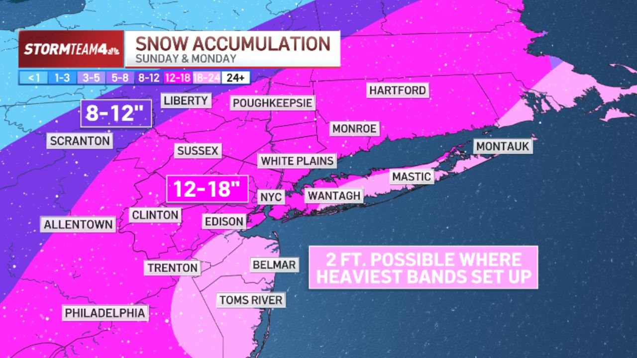
NEW YORK CITY, NEW YORK — A powerful winter storm is set to deliver widespread heavy snowfall across New York, New Jersey, and parts of Connecticut and Pennsylvania from Sunday through Monday, with forecast totals ranging from 8 to 18 inches and isolated areas possibly approaching 2 feet where the most intense snow bands develop.
Forecast projections show a broad swath of significant accumulation stretching from Scranton and Allentown in Pennsylvania through Edison, Clinton, and Sussex in New Jersey, across White Plains, Monroe, and into Hartford, Connecticut.
12 to 18 Inches Forecast Across NYC Metro
The most impactful snowfall zone centers over the New York City metropolitan area, including NYC, Edison, Clinton, and surrounding North and Central New Jersey communities. These areas are forecast to receive 12–18 inches of snow by Monday night.
Communities including White Plains, Monroe, and parts of the lower Hudson Valley are also positioned within this heavier band. Snowfall rates in the most intense periods could significantly reduce visibility and rapidly cover roadways.
The forecast map also highlights the potential for localized snowfall totals near 2 feet where the heaviest snow bands stall. These mesoscale bands can produce several inches per hour in a short period, dramatically increasing totals in narrow corridors.
8 to 12 Inches From Scranton to Liberty
A secondary band of 8–12 inches is projected across parts of northeastern Pennsylvania and upstate New York, including Scranton, Liberty, and Poughkeepsie. While totals here may be slightly lower than the NYC metro core, snowfall could still disrupt travel and create hazardous conditions.
As the storm tracks northeast, accumulation spreads into Hartford, Connecticut, where similar significant totals are expected. The broad coverage of heavy snow across state lines emphasizes the regional scale of this winter system.
Coastal and Southern New Jersey Impacts
Southern New Jersey communities including Toms River, Belmar, and areas near the Jersey Shore are forecast to receive lighter but still impactful snowfall compared to inland regions. Meanwhile, eastern Long Island locations such as Montauk, Mastic, and Wantagh remain within the heavier snow zone, particularly if storm bands pivot toward the coast.
Forecasters note that band placement will determine final totals. Slight shifts in storm track could push heavier snow east or west, changing accumulation forecasts by several inches.
Philadelphia and Trenton Also in the Path
The storm’s southern edge includes Philadelphia, Trenton, and surrounding communities. These areas appear within the broader snowfall field, with totals likely varying based on how quickly cold air locks in across southeastern Pennsylvania and western New Jersey.
Travel disruptions are expected throughout the region as snow intensifies Sunday into Monday. Commuters across New York, New Jersey, Connecticut, and Pennsylvania should prepare for:
- Snow-covered highways and reduced visibility
- Possible transit delays
- School and business closures
- Difficult Monday evening travel conditions
Two Feet Possible in Heaviest Bands
The most notable forecast detail is the potential for 2 feet of snow where the heaviest bands set up and persist. These bands can dramatically increase totals in specific communities, especially across portions of northern New Jersey and the NYC metro corridor.
Heavy snow rates combined with gusty winds could lead to localized whiteout conditions at times. Officials typically advise residents to avoid unnecessary travel during peak snowfall periods.
As the storm unfolds across the Northeast, communities from Scranton to Hartford and through the heart of New York City will closely monitor band placement and updated totals. For continued updates on major weather events impacting cities nationwide, visit ChicagoMusicGuide.com.