Northeast Blizzard Threat Explodes Overnight as Offshore Storm Rapidly Intensifies Toward New York and New England
NEW YORK, NEW YORK — What initially appeared to be a storm sliding harmlessly out to sea has rapidly intensified into a powerful coastal system, with meteorologists warning that parts of New York, New Jersey, and New England could face near-blizzard or blizzard conditions by Monday. Forecast model data shows the system deepening dramatically just offshore, transforming within hours from a marginal coastal low into a tightly wound winter storm.
Forecasters note that there was a brief window where projections kept the storm well east of the coastline. Updated guidance now shows a much stronger and closer track, increasing snowfall and wind impacts for the Northeast corridor.
From “Out to Sea” to Rapid Intensification
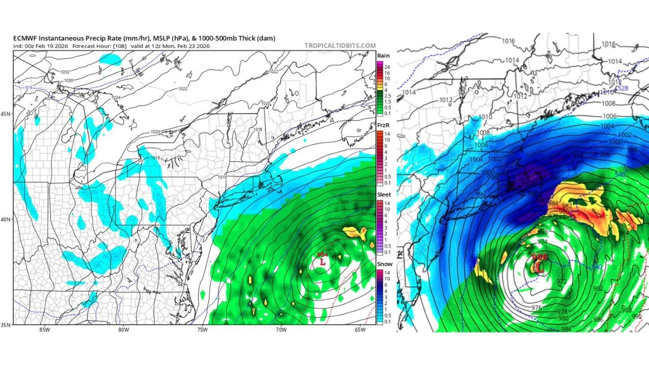
Earlier projections suggested the low-pressure system would remain offshore. However, updated model imagery shows the storm deepening significantly, with central pressure dropping into the mid-960 millibar range as it strengthens east of the Mid-Atlantic coast.
That rapid pressure fall indicates explosive development, sometimes referred to as bombogenesis, where a storm intensifies quickly over a short period. The shift has major implications for coastal communities from New Jersey through Long Island, New York City, and into Connecticut and Massachusetts.
The storm’s track now places heavy precipitation bands much closer to land, increasing the likelihood of significant snow accumulation across interior sections of the Northeast.
Heavy Snow Bands Target New York and New England
Model projections show a wide shield of snow wrapping around the western side of the intensifying coastal low. This band extends from parts of eastern Pennsylvania through northern New Jersey, across New York State, and into southern New England.
The heaviest snow is expected where deformation bands set up west and northwest of the storm’s center. These areas could experience intense snowfall rates, reduced visibility, and rapidly deteriorating travel conditions.
Communities across New York City, the lower Hudson Valley, interior Connecticut, and parts of Massachusetts may experience the most significant impacts if the storm track remains close to the coastline.
Strong Winds and Blizzard Potential
The tightening pressure gradient visible in forecast maps suggests increasing wind speeds as the system intensifies offshore. With central pressure dropping into the 960s millibars, strong northerly winds could develop along the coast.
Blizzard conditions require sustained winds or frequent gusts above 35 mph combined with heavy snow and low visibility. Given the projected structure of the storm, coastal and inland communities in New York and New England could see periods of whiteout conditions if snowfall rates and wind overlap.
Coastal areas may also face:
- Blowing and drifting snow
- Reduced visibility below one-quarter mile
- Hazardous travel during peak snowfall
Comparison to Historic Storms
Meteorologists caution that while the storm’s rapid intensification is notable, modern forecasting technology reduces the likelihood of complete surprise. Comparisons have surfaced to the historic Blizzard of 1978, though experts emphasize that today’s modeling systems provide earlier warning and improved storm tracking.
Still, the dramatic model shift highlights how quickly coastal systems can evolve. The storm transitioned within hours from appearing offshore to becoming a significant Northeast winter threat.
What Residents Should Expect
If current projections hold, snowfall and wind impacts will increase through Sunday night into Monday. Travel disruptions are likely across portions of New York, New Jersey, Connecticut, and parts of Massachusetts.
Residents should prepare for:
- Rapidly changing road conditions
- Potential school and business closures
- Strong coastal winds
- Snow removal challenges in high-impact zones
Forecast confidence has increased regarding storm strength, though exact snowfall totals will depend on final track and band placement.
As this fast-developing winter system approaches the Northeast, officials continue monitoring updates and refining impact zones. For continued updates on major winter storms, regional weather developments, and national impact events, visit ChicagoMusicGuide.com.