Historic Winter Storm Threat Intensifies for New York and New England With 50+ MPH Gusts and 2–4 Inch Per Hour Snow Rates Expected
NEW YORK, NEW YORK — Meteorologists are tracking what is being described as a potentially historic winter storm targeting the Northeastern United States from Sunday evening through Monday. Forecast guidance now shows stronger model consensus, heavy snow bands capable of producing 2–4 inches per hour, and coastal wind gusts exceeding 50 mph, raising serious concerns for blizzard conditions across parts of New York, New Jersey, and New England.
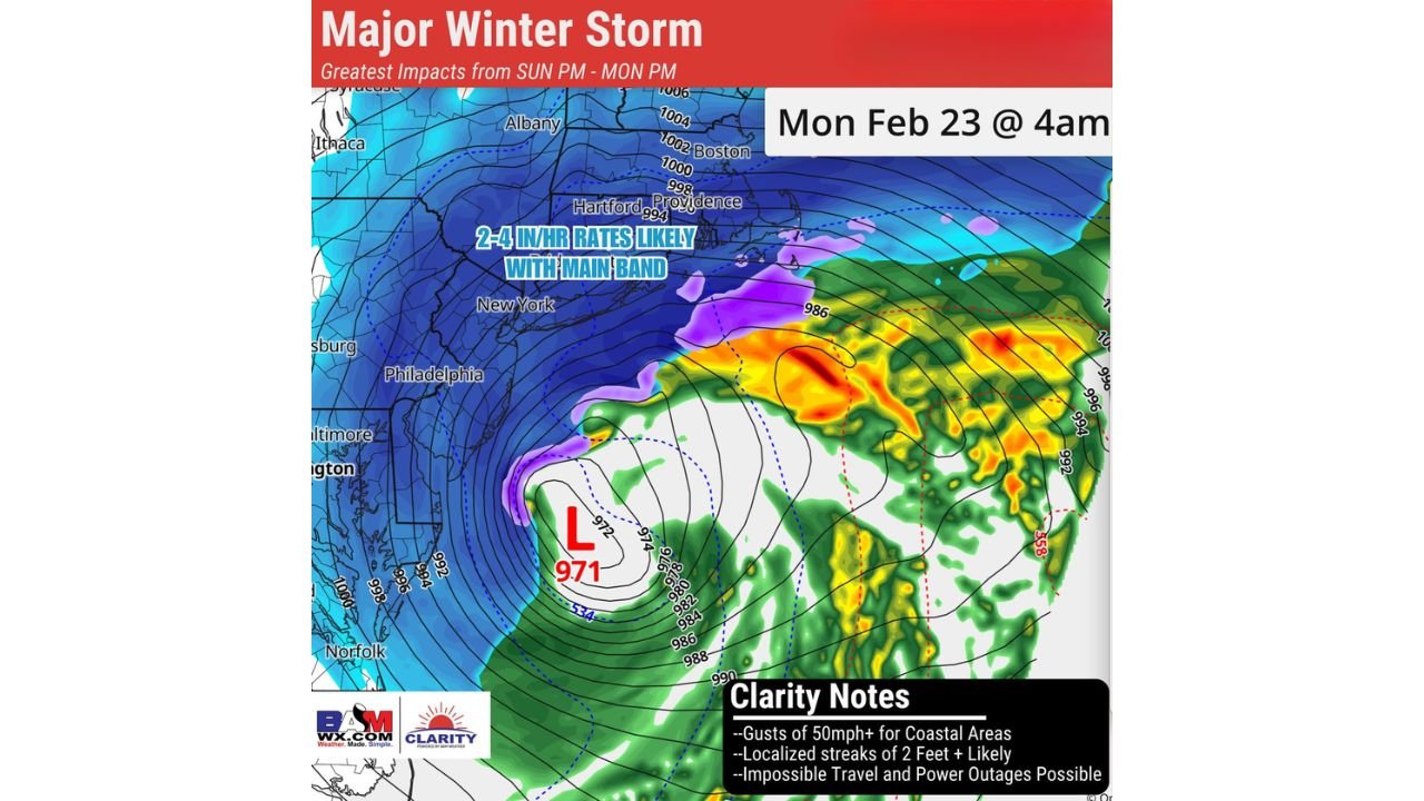
Updated projections indicate that this is not a storm to underestimate, especially as the most significant impacts are expected from Sunday PM through Monday PM.
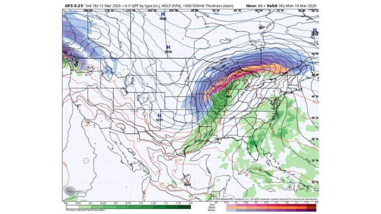
Rapidly Deepening Coastal Low Near 971 mb
Forecast imagery shows a powerful coastal low intensifying offshore with central pressure near 971 millibars early Monday morning. Such a pressure reading signals a robust winter cyclone capable of generating strong winds and heavy precipitation.
The system’s structure displays tightly packed pressure lines offshore, an indicator of strengthening wind fields along the coast. As the low deepens, cold air wrapping around the northwest side of the storm supports widespread snow across the interior Northeast.
Communities from Philadelphia through New York City, northward to Hartford, Providence, Boston, and even near Albany, appear positioned within the broader snow shield.
2–4 Inch Per Hour Snow Rates in Main Band
Forecasters highlight the potential for 2–4 inch per hour snowfall rates where the primary snow band sets up. This intense banding is expected west and northwest of the storm’s center, particularly impacting areas near New York City, Hartford, and across portions of southern New England.
Snowfall at that intensity can rapidly overwhelm road crews and create near-zero visibility conditions. Travel could become nearly impossible during peak banding periods, especially overnight into early Monday morning.
Localized “streaks” within this main band may exceed general forecasts, with projections indicating 2 feet or more possible in areas where heavy snow persists the longest.
Coastal Wind Gusts Over 50 MPH
The storm’s deepening pressure gradient supports strong northeasterly winds, particularly along coastal sections of New Jersey, Long Island, Connecticut, and Rhode Island.
Wind gusts exceeding 50 mph could combine with heavy snowfall to produce true blizzard conditions in exposed coastal communities. Blowing and drifting snow may significantly reduce visibility and create dangerous travel conditions.
Clarity forecasts also warn of:
- Localized 2-foot snowfall streaks
- Impossible travel during peak intensity
- Potential power outages due to wind and heavy snow
Greatest Impacts Sunday Night Into Monday
The timing of the storm suggests impacts will increase rapidly Sunday evening, intensify overnight, and remain severe into Monday morning. By 4 a.m. Monday, the storm’s core is projected to be fully developed offshore, with the heaviest snow and strongest winds ongoing across parts of the Northeast.
Major metropolitan areas including New York City, Boston, and Providence may experience the brunt of heavy snow bands depending on final track and mesoscale positioning.
Even a slight westward or eastward shift could dramatically alter snowfall totals for specific communities, underscoring the dynamic nature of the storm.
Not a Storm to Underestimate
Meteorologists note that model agreement has strengthened, increasing confidence in significant impacts. While modern forecasting reduces the element of surprise compared to historic events like the Blizzard of 1978, the rapid intensification and banding potential make this system particularly concerning.
Residents across New York, New Jersey, Connecticut, Rhode Island, and Massachusetts are advised to monitor official updates and prepare for severe winter conditions.
As this major winter storm approaches the Northeastern United States, emergency planners and transportation agencies are preparing for high-impact snowfall, strong winds, and possible outages. For continued updates on significant weather events affecting major cities nationwide, visit ChicagoMusicGuide.com.