Rapidly Strengthening Nor’easter to Undergo Bombogenesis Off New England, Pressure Plunging Toward 970 mb by Monday Afternoon
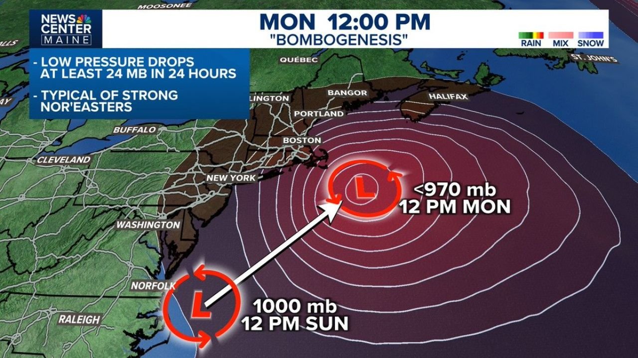
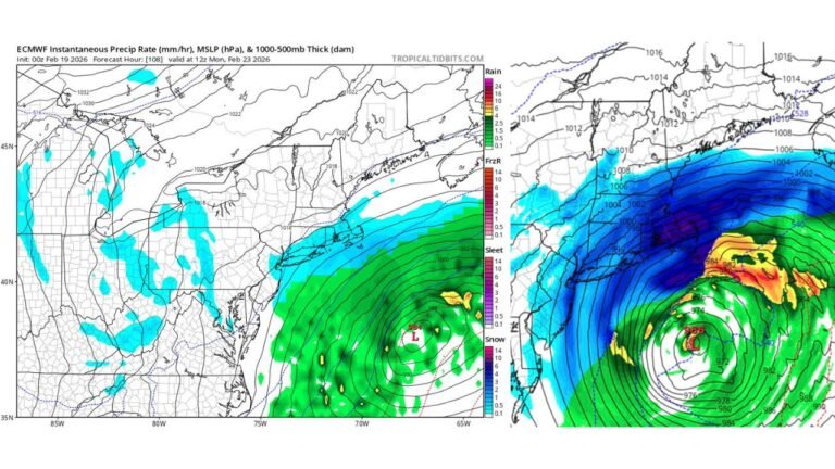
NEW ENGLAND — A powerful nor’easter is rapidly intensifying off the East Coast and is expected to undergo bombogenesis, with central pressure forecast to plunge from around 1000 mb Sunday afternoon near Norfolk, Virginia, to below 970 mb by Monday around midday offshore of New England.
That kind of drop — at least 24 millibars in 24 hours — meets the technical definition of bombogenesis and signals a storm that is strengthening at an exceptional rate.
From Norfolk to Offshore New England in 24 Hours
Forecast guidance shows the low positioned near:
- Norfolk, Virginia – 1000 mb at 12 PM Sunday
- Tracking northeastward along the coast
- Deepening rapidly offshore
- Reaching sub-970 mb by 12 PM Monday
The storm’s center is projected to be east of Boston and south of Nova Scotia by Monday afternoon, with tightly packed pressure lines indicating a very strong and organized circulation.
What Bombogenesis Means for the Northeast
Bombogenesis occurs when a storm’s pressure drops at least 24 mb in 24 hours. It is typical of strong winter nor’easters and often leads to:
- Intensifying winds
- Expanding precipitation shields
- Coastal impacts
- Rough marine conditions
The projected pressure near or below 970 mb places this system in a category often associated with significant wind potential, especially along coastal New England.
Impact Zone: Mid-Atlantic to Maine
The strengthening track suggests impacts across:
- Eastern Virginia
- The Mid-Atlantic coastline
- New York City metro
- Boston and eastern Massachusetts
- Coastal Maine
- Atlantic Canada, including Halifax
With the low rapidly deepening offshore, the most intense wind field is likely to expand over the Atlantic waters and coastal zones of New England.
Wind and Coastal Concerns
The tightening pressure gradient shown in forecast imagery indicates:
- Strong northeast winds along the coast
- Potential for gusty conditions in Boston and Portland
- Rough surf and hazardous marine conditions
As the low intensifies offshore, winds could strengthen quickly late Sunday night into Monday.
Timing Overview
- Sunday Afternoon: Low near Norfolk (~1000 mb)
- Sunday Night: Rapid intensification begins
- Monday Midday: Pressure drops below 970 mb offshore New England
- Monday Afternoon: Peak intensity as storm pulls northeast
Bottom Line
This is a classic rapidly intensifying nor’easter setup. With pressure projected to fall more than 24 mb in 24 hours, the storm is expected to officially meet bombogenesis criteria and strengthen into a powerful offshore system by Monday afternoon.
Residents along the Northeast coast should monitor local forecasts as wind and marine impacts increase.
For continued national weather updates and in-depth storm analysis, visit ChicagoMusicGuide.com.