Heavy Snow Threat Expands for March 2–6 as CPC Flags New England and Pacific Northwest for Potential Nor’easter Impact
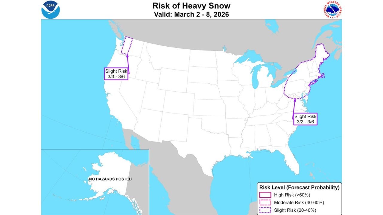
UNITED STATES — As March begins, forecasters are increasingly eyeing the potential for another impactful winter system, with the Climate Prediction Center (CPC) highlighting a risk of heavy snow between March 2 and March 6 across parts of the Northeast and the Pacific Northwest.
The newly issued outlook, valid March 2–8, 2026, outlines targeted areas where accumulating snowfall could become significant.
New England in the Spotlight for March 2–6
The CPC has designated a Slight Risk (20–40%) of heavy snow across:
- Eastern Pennsylvania
- New Jersey
- New York City metro
- Much of New England, including Boston
- Coastal Maine
The highlighted window runs March 2 through March 6, aligning with increasing odds of another Nor’easter-type setup developing along the East Coast.
While this is not yet a high-confidence major storm, the placement of the risk zone suggests forecasters are monitoring the potential for coastal development capable of delivering widespread snow.
Pacific Northwest Also Included
In addition to the Northeast corridor, the CPC outlook includes a Slight Risk (20–40%) area over western Washington, particularly:
- Olympic Peninsula
- Higher elevations near Seattle
- Cascade foothills
This window runs March 3–6, indicating another round of mountain snowfall is possible in the region.
What “Slight Risk” Means
A Slight Risk designation does not guarantee heavy snow, but it signals:
- Elevated probability compared to climatology
- Increasing model agreement on a winter setup
- The potential for impactful snowfall totals
With early March climatology still supportive of winter systems, even marginal setups can produce meaningful accumulation in the Northeast.
Why Early March Still Matters
Though meteorological spring begins March 1, the atmosphere often remains primed for significant winter storms, especially along the East Coast where coastal low pressure systems can rapidly intensify.
Recent patterns have supported active storm tracks, and forecasters are noting that odds are increasing for another Nor’easter-style system during the highlighted period.
Timeline Overview
- March 2–6: Northeast heavy snow risk
- March 3–6: Pacific Northwest heavy snow risk
- Outlook valid through March 8
Additional refinements are expected as model guidance tightens over the coming days.
Bottom Line
The Climate Prediction Center is officially flagging March 2–6 for heavy snow potential, with New England and portions of the Pacific Northwest under a Slight Risk designation.
While specifics remain uncertain, the signal for another early-March winter system is growing stronger.
For continued national weather updates and storm outlook coverage, visit ChicagoMusicGuide.com.