Major Winter Storm Signal Emerging for Northern Illinois and Northern Indiana With 8+ Inches Possible From Wednesday Evening Into Thursday
ILLINOIS AND INDIANA — A growing signal in the latest forecast data points toward a potentially major winter storm impacting northern Illinois and northern Indiana later this week, with the most significant impacts possible from Wednesday evening through Thursday evening.
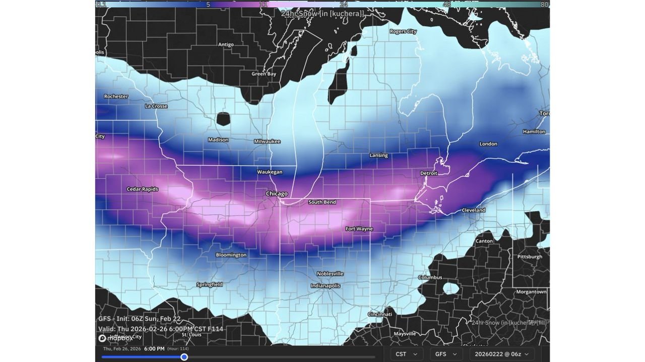
Recent GFS model runs are showing a swath of 8 inches or more of snowfall, centered directly over the Chicago metro and extending eastward into northern Indiana.
Chicago to South Bend in the Potential Bullseye
Snowfall projections show the heaviest band stretching from:
- Cedar Rapids and eastern Iowa
- Chicago and Waukegan
- South Bend
- Fort Wayne
- Toward Detroit
The deepest purple shading on the model output — often associated with higher snowfall totals — is aligned across northern Illinois into northern Indiana, placing cities like Chicago and South Bend in a potential core impact zone.
If the current trend holds, totals exceeding 8 inches would be possible in localized areas.
Timing: Wednesday Evening Through Thursday
Model timing suggests:
- Snow developing Wednesday afternoon or evening
- Intensifying overnight Wednesday
- Continuing through much of Thursday
- Tapering later Thursday evening
This timeline would bring potential impacts during both the Wednesday night and Thursday commutes.
Heavy Snow Banding Possible
The orientation of the projected snowfall band indicates the possibility of mesoscale banding — narrow corridors of heavier snowfall rates that can rapidly increase totals in short periods of time.
If banding develops over the Chicago metro, snowfall rates could briefly exceed:
- 1 inch per hour
- Reduced visibility
- Rapid roadway accumulation
Supporting Signals From National Guidance
Additional national outlook data highlights an area of elevated probability for impactful winter precipitation across:
- Northern Illinois
- Northern Indiana
- Southern Lower Michigan
This aligns with the model snowfall corridor shown in recent GFS runs.
Still Something to Monitor
It’s important to note that:
- This is still several days out
- Track shifts north or south could dramatically alter totals
- Mixing or dry slots could limit accumulation in some areas
However, the persistence of the heavy snow signal across multiple runs increases confidence that this system deserves close monitoring.
Bottom Line
Forecast data is increasingly pointing toward a major midweek winter storm for northern Illinois and northern Indiana, with the potential for 8+ inches of snow between Wednesday evening and Thursday evening.
Chicago, South Bend, and surrounding communities could see significant travel impacts if the current model trend verifies.
Stay tuned for refinements as the system draws closer.
For continued Midwest weather coverage and storm tracking updates, visit ChicagoMusicGuide.com.