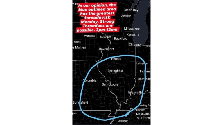
Storm’s Low Tracks Farther West Than Expected Near Virginia Beach and Outer Banks as 1000 MB Nor’easter Strengthens
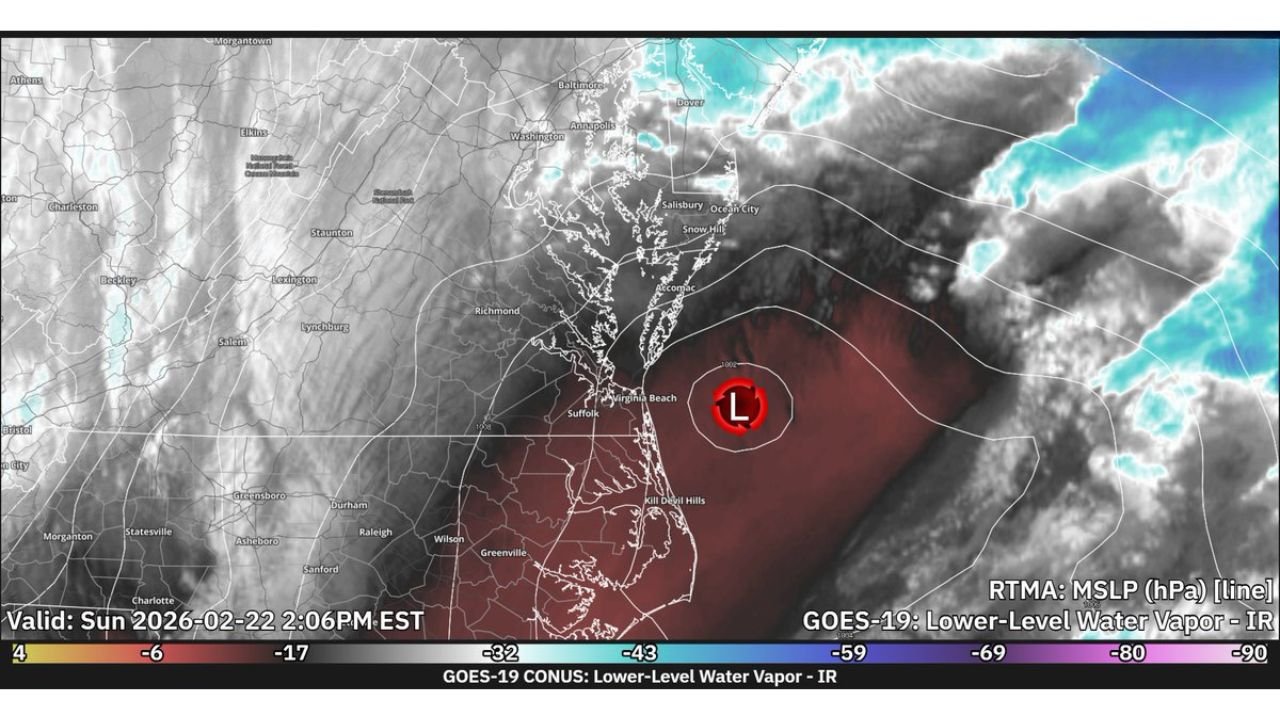
VIRGINIA BEACH, VA — The powerful Nor’easter spinning along the Mid-Atlantic coast is tracking 50 to 60 miles farther west than earlier global model projections suggested, with current satellite analysis placing the low-pressure center just offshore near the Virginia Beach and Outer Banks region at approximately 1000 millibars (MB).
High-resolution satellite imagery and short-range modeling now confirm the system’s corrected position, shifting expectations for precipitation bands and wind impacts along portions of Virginia, Maryland, and the Delmarva Peninsula.
Low Pressure Positioned Near the Outer Banks
GOES-19 lower-level water vapor imagery shows the defined circulation center just east of:
- Virginia Beach, VA
- Suffolk, VA
- The Outer Banks of North Carolina
- Coastal sections of the Delmarva Peninsula
The storm’s center is wrapped in deep moisture on its eastern flank, while drier air is evident to the west over inland Virginia.
50–60 Miles West of Earlier Global Model Runs
Earlier global forecast guidance had projected the low slightly farther east offshore. However:
- Real-time observation shows the center positioned farther west
- The HRRR short-range model has adjusted to match the observed location
- This correction alters where the heaviest precipitation bands may set up
A westward shift of this magnitude can significantly change snowfall gradients and wind impacts across densely populated coastal areas.
Current Pressure: 1000 MB and Likely Strengthening
The storm is currently analyzed at 1000 MB, indicating a well-developed coastal low. As Nor’easters intensify, falling pressure can lead to:
- Stronger wind fields
- Enhanced coastal gusts
- More organized precipitation bands
If the pressure continues to drop, wind impacts along coastal Virginia and up toward Maryland and Delaware could increase.
What the Westward Shift Means
A low tracking farther west often results in:
- Heavier precipitation closer to the coastline
- Increased wind potential inland
- Sharper snowfall cutoffs farther west
Communities in:
- Eastern Virginia
- Coastal Maryland
- Delaware
- Southern New Jersey
may see impacts shift slightly compared to earlier expectations.
Radar and Satellite Trends
Water vapor imagery clearly shows:
- A well-defined cyclonic swirl offshore
- Moisture wrapping northward along the coast
- Drier slotting developing west of the circulation
These features are typical of a maturing Nor’easter transitioning into a more organized coastal system.
Bottom Line
The Nor’easter’s center is now confirmed to be positioned farther west than earlier global model projections indicated, sitting near Virginia Beach and the Outer Banks at around 1000 MB.
That shift could mean adjustments in snowfall placement, wind strength, and coastal impacts as the system continues evolving.
For continuing real-time storm tracking and national weather updates, stay with ChicagoMusicGuide.com.