Maryland, Virginia, Pennsylvania, New Jersey and Delaware Blizzard Explodes to 978 MB as Pressure Crashes 14 MB in 3 Hours, 59 MPH Winds Hit Ocean City
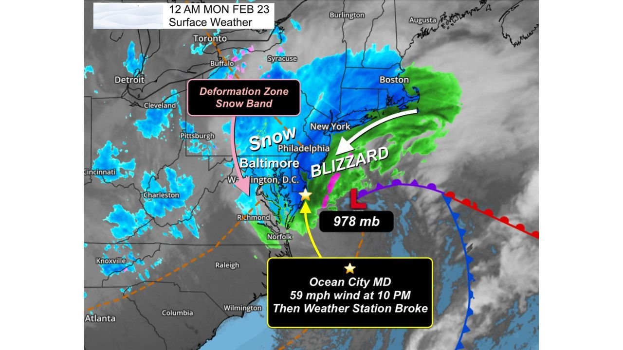
OCEAN CITY, MD — A rapidly intensifying coastal blizzard has undergone explosive strengthening overnight, with central pressure crashing from 992 mb to 978 mb in just three hours — a staggering 14 mb drop that qualifies as extreme bombogenesis.
The powerful low is now analyzed at 978 millibars, placing it in intensity territory more commonly associated with strong hurricanes than winter storms.
Super-Bombogenesis Over the Atlantic
Meteorological data shows the storm deepened dramatically in a very short period. A 14 mb drop in three hours signals:
- Explosive cyclogenesis
- Rapidly increasing wind fields
- Intensifying snowfall bands
Such strengthening has pushed the storm into a category often compared to Category 2 hurricane-level pressure equivalents, though structurally it remains a winter cyclone.
59 MPH Winds Reported in Ocean City
Ocean City, Maryland recorded 59 mph wind gusts at 10 PM, after which the local weather station reportedly went offline — possibly due to power outages or sensor damage as the storm intensified.
Strong winds have lashed:
- The Delmarva Peninsula
- Coastal Maryland
- Eastern Virginia
- Southern New Jersey
These gusts are consistent with blizzard-force coastal impacts.
Deformation Zone Driving Inland Snow
Satellite and surface analysis shows a classic deformation zone snow band stretching from:
- Philadelphia
- Baltimore
- Washington, D.C.
- Into portions of Pennsylvania
This band has been the primary driver of heavy inland snowfall, while areas closer to the beaches are seeing extreme wind combined with significant snow totals.
Beaches Set to Exceed 10 Inches
Forecast trends suggest:
- Coastal communities could exceed 10 inches of snow
- Heaviest totals align with strong wrap-around moisture
- Blizzard conditions possible in exposed coastal zones
Meanwhile, snowfall has varied sharply inland depending on placement within the deformation band.
Urban Heat Island Impact in Baltimore and Frederick
Interestingly, Baltimore (downtown) and Frederick, MD have reported lighter accumulations compared to surrounding suburbs.
Warmer city temperatures appear to have reduced snow totals in urban cores, while nearby areas have seen 3 to 5+ inches where cooling was more efficient.
Blizzard Conditions Along I-95 Corridor
The storm’s core circulation offshore is driving:
- Heavy, wind-whipped snow across Philadelphia and Baltimore
- Blizzard-like visibility at times
- Dangerous travel conditions along major highways
The 978 mb low remains just offshore, continuing to funnel moisture into the Mid-Atlantic.
Bottom Line
This rapidly deepening 978 mb blizzard has intensified at an extraordinary rate, producing near hurricane-force wind gusts along the Maryland coast and widespread snowfall across the Mid-Atlantic.
With explosive strengthening, wide snowfall ranges, and coastal wind damage potential, this storm has quickly become one of the most intense winter systems of the season.
For continuing storm analysis and national weather coverage, stay with ChicagoMusicGuide.com.