Massachusetts, Connecticut, Rhode Island and Maine Brace for Major Coastal Impacts as Strengthening Nor’easter Shows “Eye-Like” Feature on Satellite
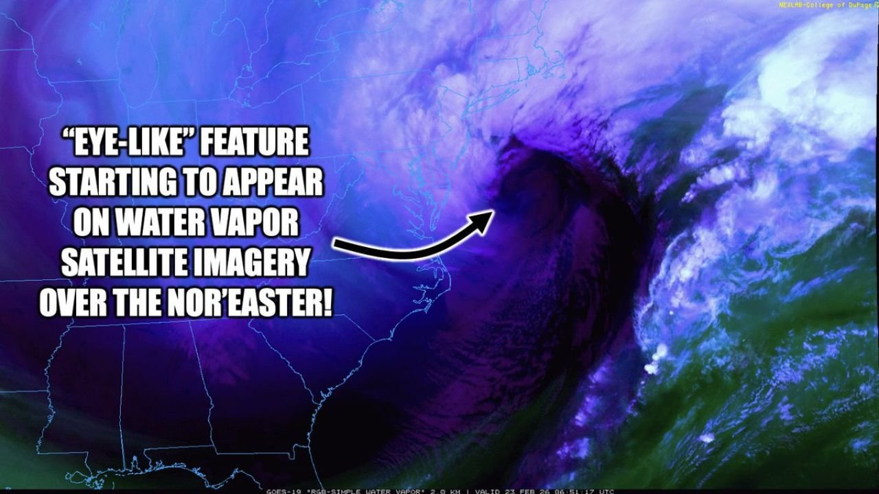
BOSTON, MASSACHUSETTS — A rapidly strengthening Nor’easter is taking on a more organized and intense structure off the East Coast, with water vapor satellite imagery now revealing an emerging “eye-like” feature as the storm targets coastal New England.
Forecasters are warning of major winter storm impacts across Massachusetts, Connecticut, Rhode Island, New Hampshire, and Maine, especially along exposed coastal communities where wind and heavy precipitation will combine.
Eye-Like Signature Appearing on Satellite
Water vapor imagery shows a tightly wrapped circulation just offshore, with a dark, dry slot curling into the center of the storm — visually resembling the core of a tropical system.
While this is not a hurricane, the structural evolution signals:
- Rapid intensification
- Strong upper-level dynamics
- Powerful wind fields wrapping around the center
The appearance of an eye-like feature in an extratropical cyclone often indicates a maturing, deepening storm.
Why This Nor’easter Is Strengthening
Unlike hurricanes, which feed on warm ocean water, a Nor’easter is an extratropical (mid-latitude) cyclone. These systems draw energy from:
- Strong temperature contrasts between cold and warm air masses
- Jet stream dynamics
- Air density gradients
As cold Arctic air collides with milder Atlantic moisture, the resulting contrast fuels explosive development.
Major Coastal Impacts Expected
Communities along:
- Coastal Massachusetts (including Boston)
- Rhode Island shoreline
- Eastern Connecticut
- Southern Maine
- Coastal New Hampshire
are likely to experience the strongest winds and heaviest precipitation bands.
Onshore flow can enhance snowfall rates inland while coastal areas may see intense wind-driven precipitation.
Inland vs Coastal Differences
New England’s coastal zones face:
- Strongest wind gusts
- Possible power outages
- Reduced visibility in heavy snow bands
Farther inland, snowfall totals may vary depending on band placement and thermal profiles.
Classic Nor’easter Structure Taking Shape
Satellite imagery highlights:
- A well-defined circulation offshore
- Moisture streaming northward into New England
- Dry air wrapping into the storm’s core
This structure is characteristic of powerful Nor’easters capable of producing blizzard conditions in coastal corridors.
Bottom Line
The strengthening Nor’easter offshore is showing signs of rapid intensification, including an eye-like feature on water vapor imagery — a signal of a powerful, organized winter cyclone.
Massachusetts, Connecticut, Rhode Island, New Hampshire, and Maine should prepare for significant coastal impacts as the system continues to strengthen.
For continued real-time winter storm coverage and national weather updates, stay with ChicagoMusicGuide.com.