Atlanta Weather Maps Spark Confusion as North Georgia Lows Plunge Into Teens While Slow-Moving Front Targets Metro Area
ATLANTA, GEORGIA — A set of weather graphics circulating from a local TV forecast has drawn attention across metro Atlanta, showing overnight lows dropping into the teens in North Georgia while a slow-moving rain front moves directly across the city Thursday afternoon. The visuals highlight sharp temperature contrasts and heavy rainfall potential, but they have also sparked questions about map accuracy.
The forecast imagery shows two major weather impacts for the region: a cold overnight stretch followed by a rain-heavy frontal boundary bringing showers and isolated storms across metro Atlanta.
Overnight Lows Dip Into the Teens Across North Georgia
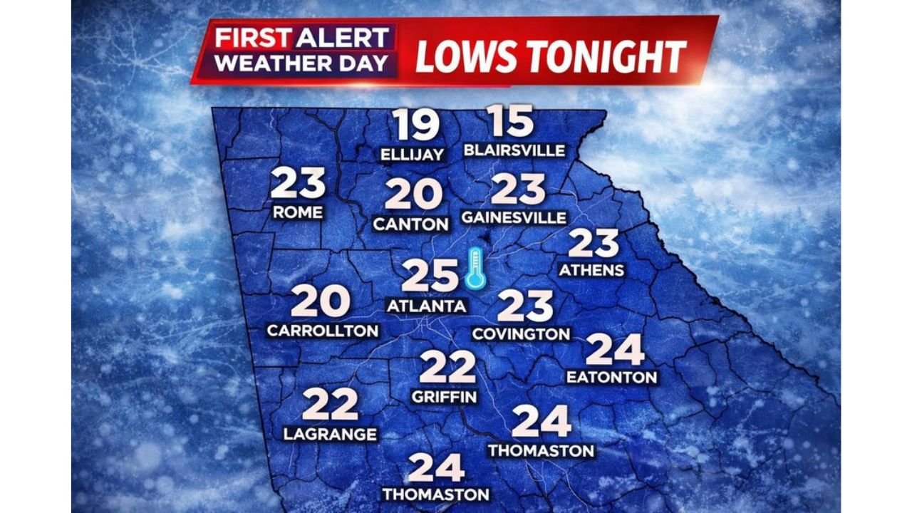
The “Lows Tonight” map displays significant cold across northern counties. Blairsville is forecast to drop to 15 degrees, while Ellijay falls to 19 degrees. Nearby cities including Canton are shown at 20 degrees, and Gainesville, Rome, and Athens are all projected around 23 degrees.
In the metro core, Atlanta itself is forecast to bottom out at 25 degrees, with surrounding communities such as Covington at 23 degrees, Carrollton at 20 degrees, and Griffin at 22 degrees.
Further south, Thomaston and Eatonton are shown near 24 degrees, while LaGrange sits at 22 degrees.
These numbers indicate a widespread freeze for much of North and Central Georgia, especially in higher elevation areas like Blairsville and Ellijay.
Slow-Moving Front Brings Rain and Isolated Storms
The second major graphic highlights a slow-moving front positioned west-to-east across northern Georgia at 1 PM Thursday, cutting directly through Atlanta, Rome, Canton, Gainesville, and toward Athens.
The forecast indicates:
- Heavy rain bands
- Isolated thunderstorms
- West-to-east movement through the evening
- No severe risk currently indicated
- Potential for ponding and lightning
By 9 PM Thursday, showers are expected to continue across metro Atlanta, with the front gradually pushing eastward.
The rainfall totals graphic shows the heaviest rain south of Atlanta, with parts of Carrollton, LaGrange, and areas stretching toward Macon potentially seeing higher accumulations through Thursday and Friday.
Rainfall Totals Concentrated South of Metro Atlanta
The forecast rainfall map (Thursday–Friday) suggests:
- 1 to 2 inches across much of north Georgia
- 2 to 3 inches possible south of Atlanta
- Localized higher pockets approaching 3 to 4 inches
Communities south of the metro corridor appear to face the highest totals, which could increase the risk of localized flooding in low-lying areas.
Forecasters emphasize the system is slow-moving, meaning rain could linger for extended periods before finally clearing.
Why the Graphics Are Drawing Attention
While the meteorological setup itself is straightforward — cold overnight temperatures followed by a rain-producing frontal boundary — viewers have questioned whether the county labels and graphic placement accurately reflect local geography.
The maps display city-based temperature markers rather than precise county outlines, which may create confusion when multiple towns share similar names or borders.
However, the overall weather message remains clear:
- A hard freeze overnight for parts of North Georgia
- Followed by a wet Thursday afternoon and evening across Atlanta and surrounding counties
For residents across Atlanta, Blairsville, Rome, Canton, and Gainesville, the main impacts will be cold early and soggy conditions later in the day.
As weather conditions continue to evolve across Georgia and the Southeast, ChicagoMusicGuide.com will keep tracking major temperature swings, heavy rain events, and regional impacts that could affect travel, events, and community activities.