Pennsylvania, New Jersey and New York Snowstorm Buzz Faces Reality Check as GFS and European Models Clash on Early March Setup
UNITED STATES — Growing social media chatter about a potential 12 to 20 inch snowstorm next Monday or Tuesday across parts of Pennsylvania, New Jersey, and New York is running far ahead of what forecast guidance can confidently support. While there are some ingredients in place for a system, long-range snowfall totals being widely shared remain highly uncertain.
Meteorologists emphasize that at 6 to 7 days out, snow totals can swing dramatically from one model run to the next — and that appears to be exactly what is happening with the early March setup.
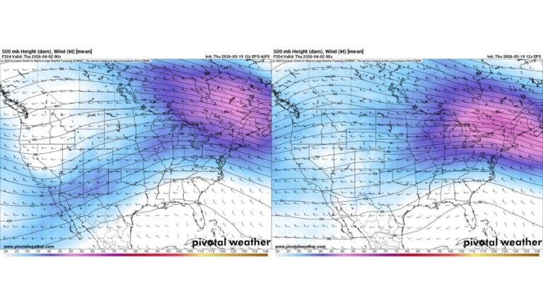
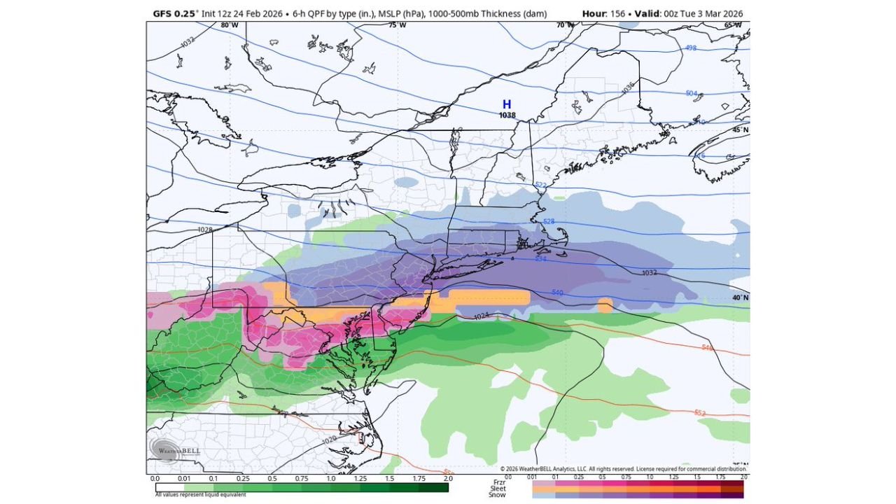
GFS Shows Snow Potential Across the Mid-Atlantic and Northeast
The latest GFS model valid around 00z Tuesday, March 3, 2026, shows a developing system tracking along the Mid-Atlantic coast.
Under this scenario:
- Snow spreads across Pennsylvania, including central and eastern portions.
- Bands extend into New Jersey and parts of New York, particularly interior sections.
- A 1038 mb high pressure system positioned to the north helps reinforce cold air at the surface.
The GFS solution suggests a decent snowstorm setup if the track verifies, especially in areas north and west of major coastal cities.
European Model Paints a Much Weaker Picture
In contrast, the European (ECMWF) model for the same timeframe shows a far less organized system.
In this scenario:
- Precipitation remains lighter and more fragmented.
- Much of the Northeast sees minimal snow accumulation.
- The coastal low appears weaker and less consolidated.
This type of model disagreement is common at a 156-hour forecast lead time, underscoring the high uncertainty.
Why 12–20 Inch Snow Totals Are Premature
Forecasters consistently caution that snowfall totals at this range should not be treated as reliable.
At 6–7 days out:
- Models can shift storm tracks by hundreds of miles.
- Temperature profiles can change enough to flip snow to rain or vice versa.
- Individual model runs can swing from 2–4 inches to 12–15 inches, then back to a near miss within 12 hours.
Ensemble guidance — which blends many model simulations — typically provides more stable insight, and that higher-confidence window generally falls within 72 to 96 hours of the event.
Cold Air and High Pressure Provide Some Ingredients
To be clear, there are legitimate elements worth watching.
The GFS map shows:
- Strong high pressure north of the region.
- Adequate cold air in place across parts of New York, Pennsylvania, and northern New Jersey.
- A coastal wave attempting to develop.
That combination can produce significant snowfall if timing and track align properly.
However, the European model’s weaker solution demonstrates that the system could just as easily trend south, stay offshore, or fail to organize.
The Broader Forecasting Challenge
The larger issue extends beyond this single system. Early sharing of eye-catching snow totals often spreads rapidly online, especially when maps show bold purples and pinks indicating heavy snow bands.
But at this lead time:
- There is no consistent signal for a 20-inch event.
- The storm still has as much potential to miss as to hit.
- Confidence remains low.
Meteorologists stress that highlighting a possible storm threat is reasonable — but presenting fixed snowfall totals this far out can create unnecessary confusion.
No Need for Panic — Yet
For residents across Pennsylvania, New Jersey, and New York, the message remains simple: stay informed, but avoid reacting to single model runs.
Confidence will increase as the forecast window narrows and ensemble trends become clearer. Until then, the early March setup should be viewed as a pattern to monitor rather than a guaranteed major snowstorm.
ChicagoMusicGuide.com will continue tracking developments in the Mid-Atlantic and Northeast, providing updates as forecast confidence improves and the model spread tightens.