Missouri, Arkansas and Illinois Deadly March 14, 2025 Tornado Outbreak Was Flagged 6 Days Early by StormNet-v4 Model With Striking Accuracy
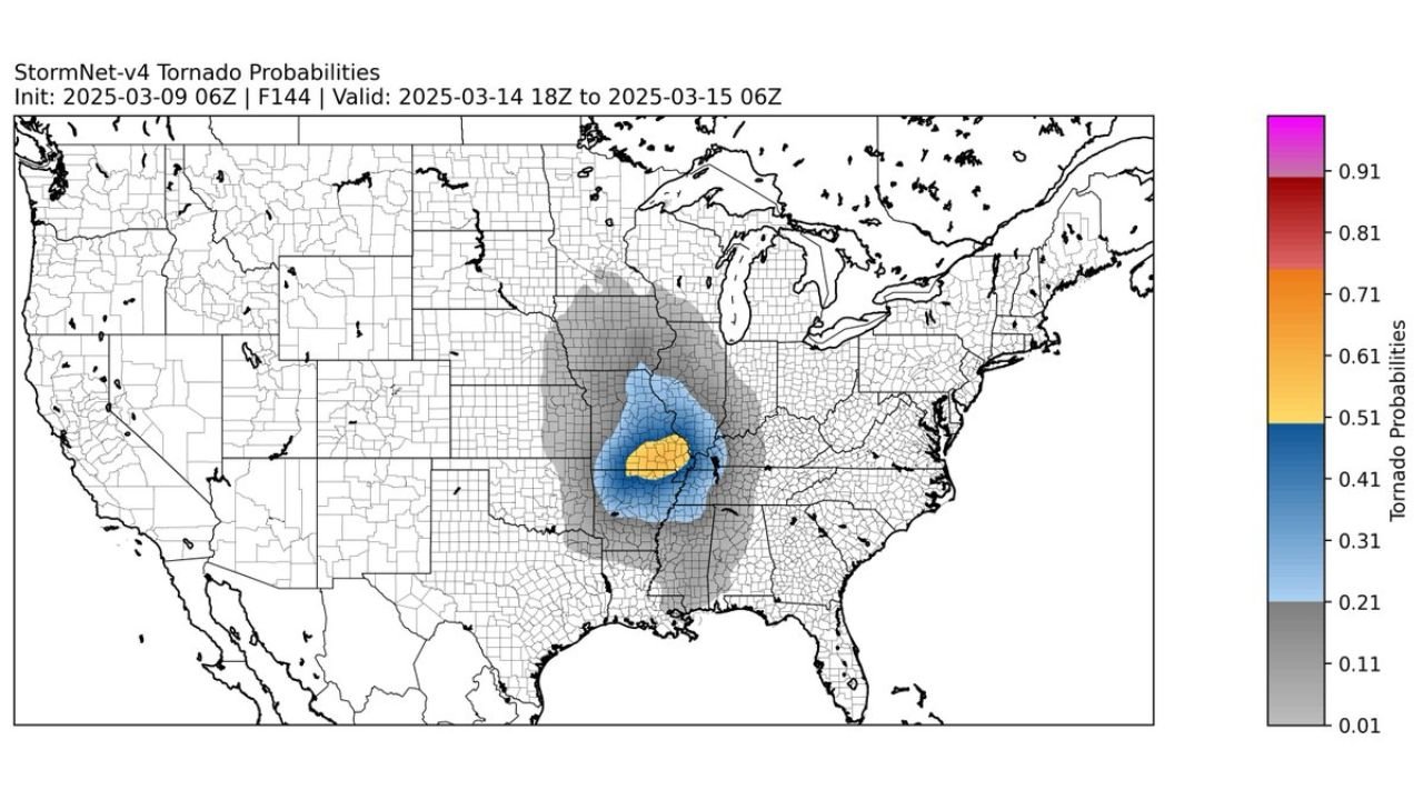
MISSOURI, ARKANSAS AND ILLINOIS — Six days before the deadly March 14, 2025 tornado outbreak, the StormNet-v4 model highlighted a concentrated tornado probability corridor centered over Missouri, Arkansas and southern Illinois — a signal that closely matched where National Weather Service survey data later confirmed tornado tracks.
The comparison between the long-range probabilistic forecast and the verified tornado paths is raising eyebrows across the weather community.
Six Days Out: A Focused Probability Bullseye
Initialized on March 9, 2025, the StormNet-v4 guidance projected tornado probabilities valid for March 14–15, 2025, showing:
- A focused higher-probability zone over central and eastern Missouri
- Extension into northeast Arkansas
- A corridor into southern and central Illinois
The model’s highest probabilities clustered near the Missouri–Arkansas border, extending northeast toward the St. Louis metro area and into parts of Illinois.
For a six-day lead time, that level of spatial concentration is notable.
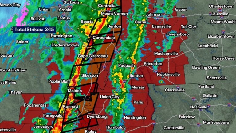
Where Tornadoes Actually Occurred
National Weather Service survey tracks later confirmed multiple tornado paths across:
- Northeast Arkansas
- Southeast and east-central Missouri
- Into southern Illinois
- Additional activity extending toward the St. Louis region
Several of the strongest and longest tracks aligned within the higher-probability zone depicted days earlier.
Track lines across Arkansas and Missouri, including areas near Cape Girardeau, St. Louis, and Jonesboro, overlapped the model’s highlighted corridor with striking similarity.
Precision in the Mid-Mississippi Valley
The model did not paint a broad, vague severe risk. Instead, it showed:
- A concentrated swath from Arkansas into Missouri
- A northeast extension into Illinois
- Lower probabilities outside that axis
That corridor mirrors the Mid-Mississippi Valley tornado belt that activated during the outbreak.
For context, long-range tornado forecasts typically struggle with precise placement at this lead time due to:
- Uncertainty in moisture quality
- Timing of upper-level energy
- Surface boundary evolution
Yet the large-scale pattern alignment allowed this event to be signaled early.
Why the Setup Was Foreseeable
The broader atmospheric pattern leading into March 14 featured:
- Strong southwest flow over the central U.S.
- Increasing Gulf moisture into Arkansas, Missouri and Illinois
- Favorable wind shear profiles across the Mid-Mississippi Valley
While smaller-scale features ultimately determined exact tornado intensity and track length, the large-scale ingredients were present — and the model captured that alignment.
Implications for Future Forecasting
This case highlights how probabilistic long-range guidance can:
- Identify corridors of heightened tornado risk
- Provide early awareness of potential high-impact days
- Support emergency preparedness messaging
It does not replace official Storm Prediction Center outlooks or NWS warnings, but it demonstrates how advanced modeling can flag regions days in advance.
For communities across Missouri, Arkansas and Illinois, early signals like this can offer valuable preparation time — especially in regions that frequently experience March severe weather.
Looking Ahead
The March 14, 2025 outbreak serves as a reminder that the Mid-Mississippi Valley — including St. Louis, Cape Girardeau, Jonesboro and surrounding areas — can face significant tornado risk even before peak spring season.
As forecasting tools continue to evolve, early detection of favorable severe patterns may improve readiness across tornado-prone states.
For continued analysis of severe weather trends affecting Illinois and the broader Midwest, stay with ChicagoMusicGuide.com.