Illinois, Indiana and Ohio Brace for 2–4+ Inches of Rain as Drought Relief Targets Chicago, Peoria and St. Louis Before Planting Season
CHICAGO, ILLINOIS — After weeks of unusually dry soil conditions across much of Illinois and the lower Great Lakes, a prolonged stretch of heavy rain is now lining up to deliver significant drought relief through at least mid-March.
Forecast maps indicate widespread soaking rainfall totals across Illinois, Indiana, Ohio, and the lower Great Lakes, with some areas potentially receiving more than four inches over the next seven days.
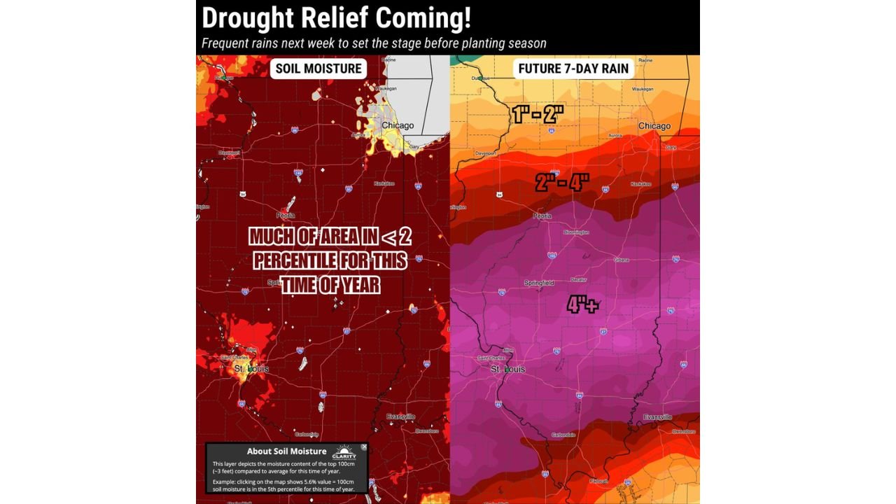
Soil Moisture Running Critically Low
Current soil moisture data shows much of:
- Central Illinois
- Western Illinois
- Areas near Peoria
- Portions of the St. Louis metro region
- Southern Illinois
- Parts of Indiana
are sitting in the lowest percentiles for this time of year — in some spots below the 2nd percentile.
That means soil conditions are significantly drier than what is typical heading into late winter and early spring.
Such dryness raises early concerns ahead of planting season, especially for agricultural areas across the Midwest.
Heavy Rain Bands Setting Up Across Illinois
The upcoming 7-day rainfall outlook shows a pronounced gradient across the state:
- Northern Illinois, including Chicago, may see 1–2 inches
- Central Illinois, including Peoria and Bloomington, could receive 2–4 inches
- Southern Illinois and areas near St. Louis and Carbondale may top 4 inches
The heaviest axis appears focused from central into southern Illinois, extending toward:
- Southern Missouri
- Western Kentucky
- Southern Indiana
This aligns with an active storm track funneling Gulf moisture northward into the Ohio Valley and lower Great Lakes.
Lower Great Lakes and Ohio Valley Also Soaked
Beyond Illinois, heavy rainfall is expected across:
- Indiana
- Ohio
- Western Kentucky
- Western Pennsylvania
- Portions of southern Michigan
The pattern remains active through at least mid-March, meaning this is unlikely to be a one-day event. Instead, multiple rounds of rain are possible as repeated systems move through the region.
Drought Relief, But Also Flood Concerns
While the rain is much needed, rapid accumulation — especially 3 to 4+ inches — could lead to:
- Ponding in low-lying areas
- River rises
- Localized flooding if storms train over the same corridor
With soils currently dry and compacted, initial rainfall may absorb efficiently. But heavier bursts could overwhelm drainage systems, particularly in urban corridors like Chicago and St. Louis.
Timing Before Planting Season
For agricultural communities across Illinois, Indiana, and Ohio, the rainfall could help recharge soil moisture ahead of spring fieldwork.
Forecasters note that while the pattern remains active into mid-March, breaks may become more common toward late March into April — a more favorable window for field preparation.
What This Means for Chicago
For the Chicago metro area, the expectation of 1–2 inches over the next week would:
- Improve topsoil moisture
- Reduce early spring fire risk
- Boost reservoir and groundwater levels
The more substantial rainfall south of the city could significantly reshape drought conditions across central and southern Illinois.
Bottom Line
An active March pattern is now delivering:
- Frequent storm systems
- Widespread rainfall
- 2–4+ inch totals across Illinois
- Much-needed drought relief for the lower Great Lakes and Ohio Valley
For Chicago and the surrounding Midwest, this stretch of rain may be exactly what the region needs before planting season ramps up.
Stay with ChicagoMusicGuide.com for continuing updates as this prolonged rain pattern unfolds across Illinois and the Midwest.