March 8–12 Severe Weather Threat Grows from Texas and Louisiana into Mississippi Valley, With Midwest in Play as Powerful Trough Ejects from Rockies
UNITED STATES — A potentially active and volatile stretch of weather is beginning to take shape for March 8–12, with growing ensemble support for increased severe storm potential from the Deep South northward into parts of the Midwest.
While specifics remain uncertain, multiple forecast signals suggest that a series of troughs ejecting out of the Rockies could provide repeated opportunities for robust thunderstorms — some of which may become severe.
March 9–10 Timeframe Stands Out
Ensemble guidance highlights March 9–10 as a particularly noteworthy window.
Upper-level maps show a strong, digging trough across the western United States with powerful mid-level winds spreading into the Plains and Mississippi Valley. This type of setup often supports:
- Strong wind shear
- Organized storm development
- Widespread thunderstorm coverage
The jet stream configuration favors dynamic lift across:
- Texas
- Louisiana
- Arkansas
- Mississippi
- Alabama
- Possibly northward into Missouri, Illinois, and portions of the Midwest
Deep Gulf Moisture Surges North
Dew point projections show rich Gulf moisture lifting northward into the Deep South and lower Mississippi Valley.
Widespread 50s and 60s dew points extend from:
- Southeast Texas
- Southern Louisiana
- Mississippi and Alabama
- Into western Tennessee and Arkansas
This moisture return is critical for severe storm development.
Without it, storms struggle. With it, the environment becomes far more unstable.
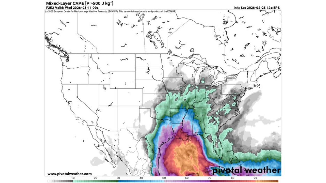
Instability and Shear Align
Mixed-layer CAPE projections indicate moderate instability developing across the southern Plains into the Gulf states.
Meanwhile, strong 500mb winds — often exceeding 70 to 100 knots in the core of the upper jet — overspread the region.
That combination of:
- Strong instability
- Powerful wind shear
- Forcing from ejecting troughs
creates a classic early-spring severe weather pattern.
Midwest Also Worth Watching
While the Deep South appears most favored initially, ensemble support suggests the severe corridor could shift northward.
Illinois, Missouri, and surrounding Midwest states may need to monitor:
- Strong wind potential
- Organized squall lines
- Embedded supercells
The exact northward extent will depend heavily on how quickly warm air and moisture advance.
Multiple Rounds Possible March 8–12
The broader March 8–12 window may feature more than one opportunity.
If multiple troughs eject from the Rockies in succession, each wave could:
- Replenish Gulf moisture
- Reignite instability
- Trigger additional severe storm clusters
This would increase the risk for more widespread impacts rather than a single isolated event.
Uncertainty Remains — But Signals Are Strong
At this range, details such as exact storm modes, tornado potential, or specific city impacts cannot be pinpointed.
However, what stands out is the consistency in ensemble guidance showing:
- A favorable large-scale pattern
- Moisture return from the Gulf
- Strong upper-level support
- Repeated storm opportunities
That signal is difficult to ignore.
Bottom Line
The March 8–12 timeframe is increasingly likely to feature an active severe weather pattern focused on the Deep South — with potential expansion northward into the Midwest.
Residents across the southern Plains, Gulf states, and portions of the Mississippi Valley should begin monitoring forecasts closely as we move closer to the event window.
Stay with ChicagoMusicGuide.com for continued updates as this developing early-March severe weather setup becomes clearer.