Texas, Oklahoma, Kansas, Illinois and Indiana Could Face a Two-Sided March 10–12 Storm With Blizzard Conditions West and Tornado Threat East
UNITED STATES — The March 10–12 timeframe is drawing serious attention from forecasters as new European model guidance signals a potentially powerful cross-country storm system that could deliver blizzard conditions across parts of the Plains while sparking a tornado outbreak across the Midwest and Ohio Valley.
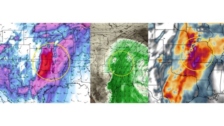
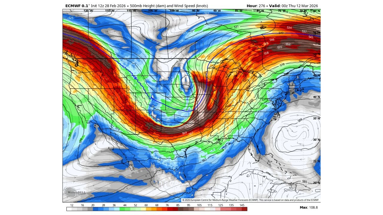
The latest ECMWF 500mb height and wind speed projections valid late March 11 into early March 12 show an intense, negatively tilted trough digging into the central United States — a classic setup for high-impact winter weather on the cold side and severe thunderstorms on the warm side.
Blizzard Potential From Colorado and Kansas Into Nebraska and Iowa
On the cold side of the system, strong upper-level dynamics are forecast to wrap across:
- Colorado
- Kansas
- Nebraska
- Portions of Iowa
- Possibly western Missouri
The model depicts a tightly wound mid-level low with powerful wind fields wrapping around the backside of the storm. If surface temperatures cooperate, this could translate into heavy snow and strong winds — a combination capable of producing near-blizzard or blizzard conditions.
The deep blue and green shading across the central Plains indicates strong cold-core energy, while the intense jet streak (shown in red/orange wind speeds exceeding 100 knots) supports rapid cyclogenesis potential.
Tornado Outbreak Risk From Texas to Illinois and Indiana
Meanwhile, on the warm side of the system, a powerful south-to-north jet is projected to surge across:
- Texas
- Oklahoma
- Arkansas
- Missouri
- Illinois
- Indiana
- Possibly into Kentucky
The pronounced negative tilt and strong wind shear profile raise concern for organized severe thunderstorms. Systems like this historically support:
- Supercells
- Damaging straight-line winds
- Large hail
- Tornado potential
The corridor from eastern Texas through Oklahoma into Illinois and Indiana would sit in the most favorable overlap of moisture return and wind shear if current projections verify.
Chicago Area Monitoring Closely
For the Chicago region and surrounding Midwest areas, this system bears close watching. Depending on the exact track:
- Northern Illinois could be on the colder fringe with rain changing to snow and strong winds
- Central and southern Illinois could see severe thunderstorms
- Indiana could sit within the stronger severe corridor
Even small shifts in the storm track will dramatically change impacts locally.
A Classic High-Impact March Setup
March is known for volatile temperature contrasts, and this projected system exemplifies that risk.
Strong jet streak energy diving into the Southwest, combined with Gulf moisture surging northward, creates a high-contrast environment. The ECMWF depiction shows a well-defined wraparound low — often associated with rapidly intensifying surface cyclones.
Historically, setups like this have produced:
- Major Plains snowstorms
- Midwest windstorms
- Ohio Valley tornado outbreaks
Still Several Days Away — But Signals Are Strong
It’s important to note that this forecast window is still several days out, and fine details will evolve. However, the consistency and intensity of upper-level signals in the European model suggest this is not a weak or disorganized system.
Forecasters are closely watching trends to determine:
- Exact snow corridor placement
- Severe weather risk zones
- Wind magnitude
- Storm timing
Bottom Line
March 10–12 could bring a high-impact, two-sided storm across the United States, with potential blizzard conditions from Colorado through Nebraska and a tornado threat stretching from Texas to Illinois and Indiana.
ChicagoMusicGuide.com will continue monitoring model trends and provide updates as the forecast becomes clearer.