Ohio, Indiana, Kentucky and West Virginia Bracing for 3–5 Inches of Rain as Repeated Storm Rounds Raise Flood Threat Into Mid-March
OHIO — A major pattern shift is underway across the Ohio Valley, and it could bring repeated rounds of heavy rain to Ohio, Indiana, Kentucky and West Virginia starting Monday into Tuesday and continuing through the following week.
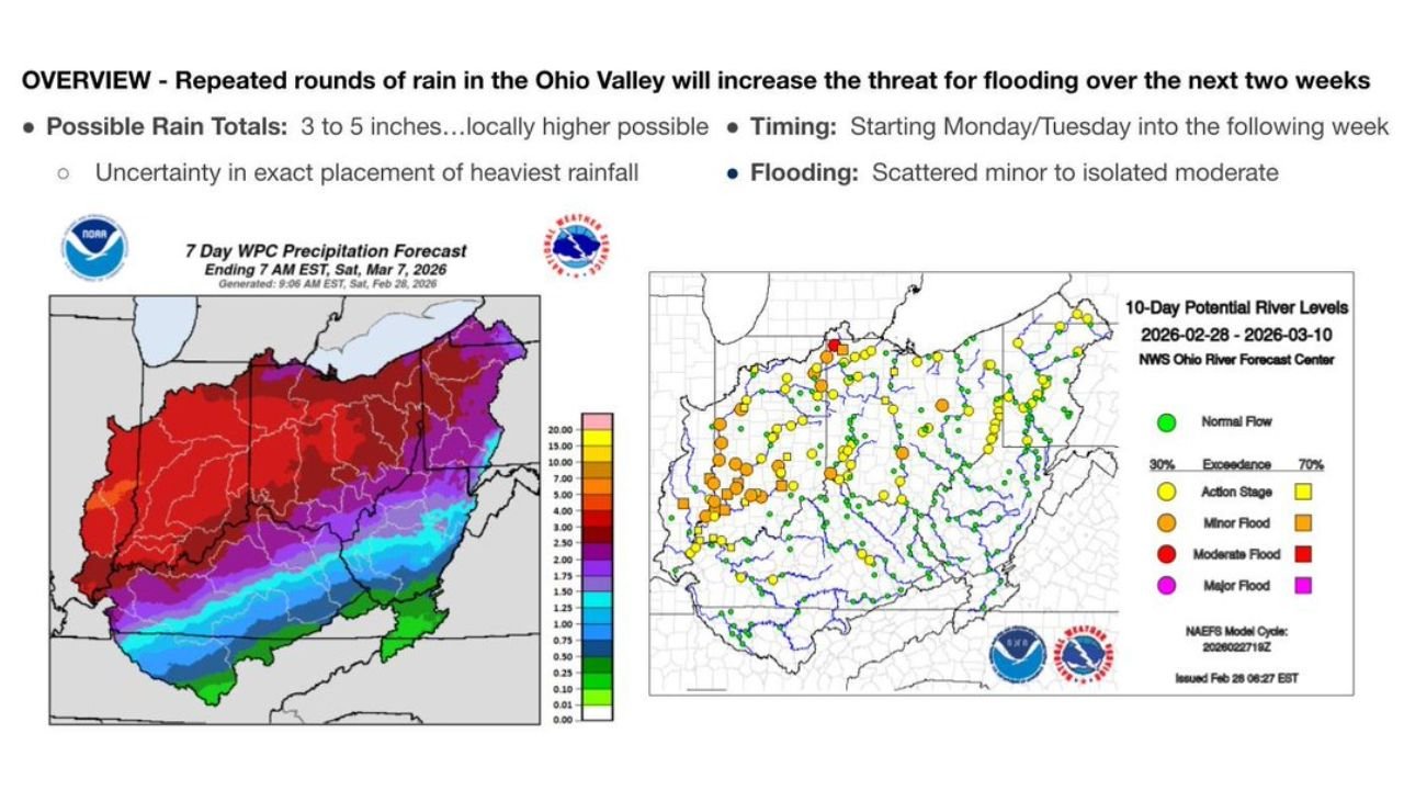
According to the latest Ohio River Forecast Center water outlook, widespread rainfall totals of 3 to 5 inches are expected over the next seven days — with locally higher amounts possible in some areas. The extended wet stretch is increasing the threat for flooding across the region.
Widespread Heavy Rain Expected Across the Ohio Valley
The 7-day precipitation outlook highlights a broad swath of significant rainfall across:
- Ohio
- Indiana
- Kentucky
- West Virginia
- Portions of Pennsylvania
- Southern parts of Illinois
The heaviest totals are centered over central and southern Ohio, much of Indiana, and northern and central Kentucky, where deep red shading indicates higher rainfall amounts.
While exact placement of the heaviest bands remains uncertain, confidence is growing that much of the Ohio Valley will see multiple rounds of steady rainfall rather than a single storm system.
Flood Threat Increasing — Minor to Isolated Moderate Flooding Possible
River forecast guidance shows numerous gauges trending toward elevated levels across the basin.
The 10-day potential river level outlook indicates:
- Scattered minor flooding
- Isolated moderate flooding
- Multiple river locations approaching action stage
Yellow and orange indicators are spread across much of Indiana, Ohio and Kentucky, signaling rising concern along tributaries and mainstem rivers.
Areas with already saturated ground conditions will be especially vulnerable if rainfall totals trend toward the higher end of projections.
Timing: Monday/Tuesday Through the Following Week
Forecasters note the pattern shift begins early in the week and may persist for up to two weeks.
Instead of one intense rainfall event, this setup favors:
- Repeated storm systems
- Persistent moisture feed
- Limited drying time between rounds
This type of pattern can gradually overwhelm drainage systems, especially in urban corridors and flood-prone river basins.
Southern Illinois Also Watching Closely
Though the core of the rainfall axis appears centered east of Chicago, southern portions of Illinois could also see elevated rainfall totals and rising rivers.
If heavier rain bands shift slightly west, parts of central and southern Illinois may experience localized flooding issues as well.
What This Means for the Midwest
For residents across the Ohio Valley:
- Monitor local river forecasts
- Prepare for possible road closures in flood-prone areas
- Avoid driving through water-covered roadways
Even minor flooding can create travel hazards, particularly in low-lying communities.
Bottom Line
Ohio, Indiana, Kentucky and West Virginia are entering a prolonged wet pattern that could deliver 3 to 5 inches of rain — possibly more in isolated areas — over the next week.
With repeated storm rounds expected and rivers already responding, scattered minor flooding and isolated moderate flooding appear increasingly likely.
ChicagoMusicGuide.com will continue tracking this developing Ohio Valley rain and flood situation as updated guidance becomes available.