Pennsylvania, Maryland, Virginia and New Jersey Now Expected to Avoid Major Snow as Early-Week Wintry Threat Shifts Toward Brief Tuesday Morning Mix
UNITED STATES — The threat of widespread snow across parts of Pennsylvania, Maryland, Virginia and New Jersey early next week is now fading, but a brief window for light wintry mix Tuesday morning still remains on the table.
For several days, models had hinted at the possibility of accumulating snow or frozen precipitation Monday into Tuesday. However, the latest guidance suggests most of the region will stay largely dry through Monday night, with only a limited chance for light snow.
Snow Potential Monday Now Much Lower
Earlier projections showed cold air sliding southward with highs in the 30s across portions of the Mid-Atlantic. That setup had raised concern for snow development Monday afternoon into the evening.
Now, most forecast models indicate:
- Little to no precipitation through Monday night
- Dry conditions dominating much of Pennsylvania, Maryland and Virginia
- Only isolated light snow signals in some guidance
The American GFS model continues to suggest a narrow window for light snow Monday afternoon into evening. However, that model has recently shown a tendency to over-simulate precipitation, and forecasters are leaning toward the drier consensus.
Tuesday Morning: A Brief Wintry Mix Possible
As a warm front lifts north early Tuesday morning, some light precipitation may develop.
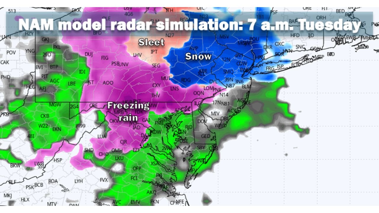
The NAM model simulation for 7 a.m. Tuesday shows:
- A band of freezing rain across central and western Maryland
- Mixed sleet across portions of central Pennsylvania
- Snow farther north into upstate New York
- Plain rain across southern Virginia and parts of coastal areas
The highest concern for brief slick spots appears north and west of the Interstate 495 Beltway region, including interior sections of Maryland and southern Pennsylvania.
Impacts Likely Limited and Short-Lived
While temperatures early Tuesday could be marginally cold enough for light freezing rain or sleet, the window for frozen precipitation appears brief.
Forecast trends suggest:
- Temperatures rising above freezing by mid-morning
- Precipitation transitioning to rain
- Limited accumulation potential
Untreated surfaces could see isolated slick spots during the early commute, especially in elevated and rural areas.
Warmer Air Wins Out Quickly
The key driver behind the fading snow threat is the stronger push of milder air northward with the advancing warm front.
Once the warmer air mass takes control:
- Ice risk diminishes quickly
- Surface temperatures climb above 32°F
- Roads improve rapidly
This reduces the likelihood of a prolonged icing event.
Bottom Line
Snow chances for Pennsylvania, Maryland, Virginia and New Jersey early next week have largely diminished. Most of Monday now looks dry.
A brief period of light wintry mix — including sleet or freezing rain — remains possible early Tuesday morning, mainly north and west of the Beltway, but impacts appear minor and short-lived.
ChicagoMusicGuide.com will continue monitoring forecast updates as models refine the timing and placement of Tuesday’s precipitation.