Maryland and Baltimore Metro Could See Light Snow Monday Followed by Early Tuesday Freezing Rain Threat Across Annapolis, Frederick and Westminster
UNITED STATES — A late-winter weather twist is developing for Maryland, with forecast models now indicating light snow potential across the Baltimore Metro on Monday, followed by a possible freezing rain threat early Tuesday morning.
Short-range guidance, including high-resolution model projections, shows a narrow band of light snow spreading across central Maryland during the day Monday before temperatures hover near freezing.
Light Snow Possible Monday Afternoon
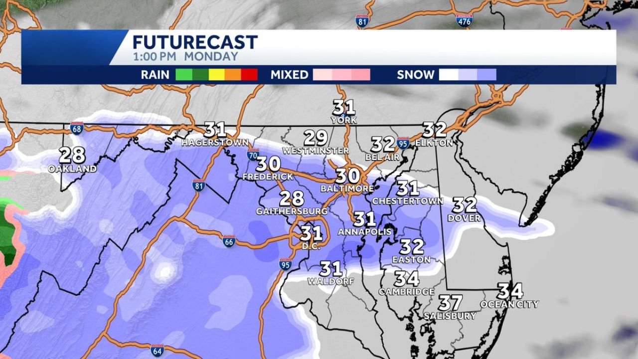
Futurecast projections for 1:00 PM Monday show snow (shaded in blue) extending across:
- Baltimore
- Annapolis
- Frederick
- Gaithersburg
- Westminster
- Hagerstown
- Parts of northern Maryland
- Into portions of Washington, D.C.
Temperatures during this period appear marginal, generally ranging from:
- 28°F in Gaithersburg
- 30°F in Baltimore
- 31°F in Annapolis and D.C.
- 29°F in Westminster
- Low 30s across eastern Maryland communities such as Chestertown and Easton
Given these readings, minor accumulations are possible in some areas, especially on grassy or elevated surfaces. Road impacts would depend heavily on intensity and surface temperatures.
Western Maryland Coldest
Farther west, including Oakland, temperatures near 28°F support a better chance for snow to stick. Hagerstown and Frederick also sit near the freezing mark, increasing the likelihood of light accumulation.
Meanwhile, coastal areas such as:
- Ocean City (34°F)
- Salisbury (37°F)
- Cambridge (34°F)
Remain marginally warmer, limiting significant accumulation potential.
Freezing Rain Risk Early Tuesday
As the system evolves, light freezing rain (ice) remains possible early Tuesday morning.
This would occur if:
- Surface temperatures remain at or just below freezing
- Warmer air overrides at higher levels
- Precipitation continues in a lighter, lingering form
Even minor icing can create slick spots on untreated roads, bridges and elevated surfaces.
Why This Setup Is Tricky
This event is temperature-sensitive. With many locations hovering between 30°F and 32°F, small shifts in:
- Storm track
- Precipitation intensity
- Surface temperatures
Could determine whether areas see:
- Mostly wet roads
- A light coating of snow
- Or patchy freezing rain
Because of this narrow temperature window, confidence remains moderate but not locked in.
Bottom Line
Baltimore, Annapolis, Frederick and surrounding Maryland communities may see light snow Monday with minor accumulation possible, followed by a risk of light freezing rain early Tuesday morning.
Impacts appear limited at this time, but residents should stay alert for updates as temperatures near freezing could create localized slick spots.
ChicagoMusicGuide.com will continue monitoring developments as this marginal winter system moves across Maryland and the Mid-Atlantic.