Chicago to New York and Houston to Atlanta Brace for Record-Breaking 80° Heat as Rare Early-March Warm Surge Engulfs Midwest and Southeast
UNITED STATES — A powerful early-March warm surge is set to send temperatures soaring from Texas and Louisiana through Chicago, Atlanta, and New York, with some cities potentially challenging or breaking record highs as a late-May-style air mass spreads across the central and eastern U.S.
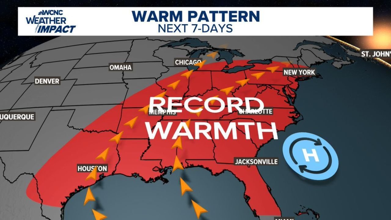
Forecast maps show a broad swath of record warmth expanding from the Gulf Coast to the Great Lakes and into the Northeast over the next seven days.
Warm Pattern Expands from Houston to Chicago and New York
The projected warm corridor stretches from:
- Houston and Dallas, Texas
- Through Memphis, Tennessee
- Into St. Louis and Chicago
- Eastward toward Atlanta, Charlotte, Washington D.C., and New York
This is not just a slight warmup. The signal indicates widespread above-average temperatures with high confidence through the 6–10 day period (March 8–12).
Much of the Midwest and Southeast is shaded in darker orange and red tones — indicating strong odds of temperatures running well above normal.
80-Degree Weather in Early March
Forecasters note that parts of the Southeast and southern Mid-Atlantic could experience:
- Multiple consecutive days in the 80s
- Temperatures more typical of late May than early March
- Record highs potentially falling midweek
Cities like:
- Atlanta
- Charlotte
- Jacksonville
- Houston
- Possibly even areas near Chicago and the Ohio Valley
could experience unusually warm afternoons for this time of year.
Jet Stream Pattern Favors Warmth
The jet stream configuration shows a pronounced ridge over the eastern half of the country.
This setup:
- Allows warm Gulf air to surge northward
- Suppresses cold air intrusions
- Maintains a stable, high-pressure dominated regime
A large “H” (high pressure) off the Southeast coast further supports continued warmth and southerly flow into the Midwest and East Coast.
Meanwhile, cooler air remains displaced well to the north and west.
Midwest Impact: Chicago and Surrounding States
For Illinois and the broader Midwest, the warm signal is significant.
Chicago sits within the zone of elevated warmth probabilities. While exact high temperatures will vary day to day, the pattern supports:
- Above-average daytime highs
- Mild overnight lows
- A noticeable early-spring feel
This kind of early-season warmth can accelerate budding trees and early vegetation growth.
Southeast and Gulf Coast: Prolonged Heat Stretch
The Southeast, including:
- Georgia
- South Carolina
- North Carolina
- Florida
- Alabama and Mississippi
appears poised for a sustained stretch of well-above-average temperatures.
The phrase “late May weather in early March” accurately describes the intensity of the projected air mass.
Bottom Line
An expansive ridge and favorable jet stream pattern are combining to deliver record-challenging warmth from Texas to Chicago to New York over the next week.
With 80-degree readings possible in several southern and southeastern cities — and strong above-average signals across the Midwest and Northeast — early March is about to feel much more like late spring.
ChicagoMusicGuide.com will continue tracking temperature trends and any record-setting updates as this unusually warm pattern unfolds.