Dallas–Fort Worth, Oklahoma City, Wichita and Kansas City Face Widespread Severe Storm Threat Friday Along I-35 from Texas to Southern Iowa
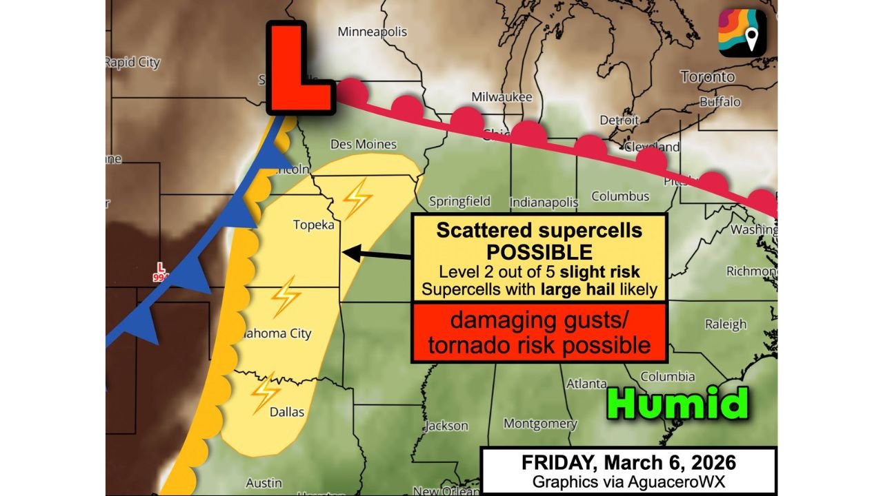
UNITED STATES — Friday, March 6, 2026 is shaping up to potentially deliver the season’s first widespread severe weather event along the I-35 corridor, stretching from Dallas–Fort Worth, Texas through Oklahoma City, Wichita, Kansas City and into southern Iowa.
Forecast guidance highlights a classic early-season “Tornado Alley” setup, with strong low pressure near Sioux Falls, South Dakota pulling warm, humid Gulf air northward while a cold front advances from the west.
Target Zone: I-35 from North Texas to Southern Iowa
The primary severe corridor includes:
- Dallas–Fort Worth, Texas
- Waco, Texas
- Oklahoma City, Oklahoma
- Tulsa, Oklahoma
- Wichita, Kansas
- Kansas City, Missouri
- St. Joseph, Missouri
- Extending north toward southern Iowa
Storms are expected to develop by mid-afternoon — roughly between 3 and 4 p.m. — as the atmosphere destabilizes ahead of the front.
Main Hazards: Large Hail and Damaging Winds
The dominant threats appear to be:
- Large hail up to hen egg size
- Damaging wind gusts
With colder air aloft spilling south in a jet stream dip, hail production could be enhanced, especially within any rotating supercells that form.
Tornado Risk Also in Play
Wind shear profiles — including changing wind direction and speed with height — suggest that at least a few storms could rotate strongly enough to produce tornadoes.
The tornado risk is not guaranteed across the entire corridor, but forecasters indicate there is a “decent chance” of tornado development, particularly with discrete supercells ahead of the main line.
Evening and Nighttime Concern
Another factor raising concern is the strengthening low-level jet after sunset. As winds intensify a few thousand feet above the surface:
- Storms may maintain intensity after dark
- Severe weather potential could extend into the evening and nighttime hours
This increases the risk for dangerous overnight warnings, especially across Oklahoma, Kansas and Missouri.
Atmospheric Setup: Classic Clash
The system features:
- Low pressure centered near Sioux Falls, South Dakota
- Warm, humid air surging north from the Gulf of Mexico
- A sharp cold front pushing east from the Plains
The collision of dry western air and moist southern air creates a volatile environment capable of producing scattered supercells.
Bottom Line
Friday, March 6 could bring a widespread severe weather episode along I-35 from North Texas through Oklahoma, Kansas and into southern Iowa, with threats including hen-egg-size hail, damaging winds and a possible tornado risk.
Residents in cities such as Dallas, Oklahoma City, Wichita and Kansas City should monitor updates closely and ensure they have multiple ways to receive warnings, especially heading into the evening hours.
ChicagoMusicGuide.com will continue tracking this developing severe weather setup and provide updates as forecast confidence increases.