70s to Near 80 Degrees Target Virginia and Maryland by Saturday as Potomac Temperature Divide Keeps Northeast Maryland Cooler Late Week
UNITED STATES — A surge of above to well-above average temperatures is on the way for parts of the Mid-Atlantic, with readings potentially flirting with 80 degrees by Saturday, especially across Virginia and southern Maryland.
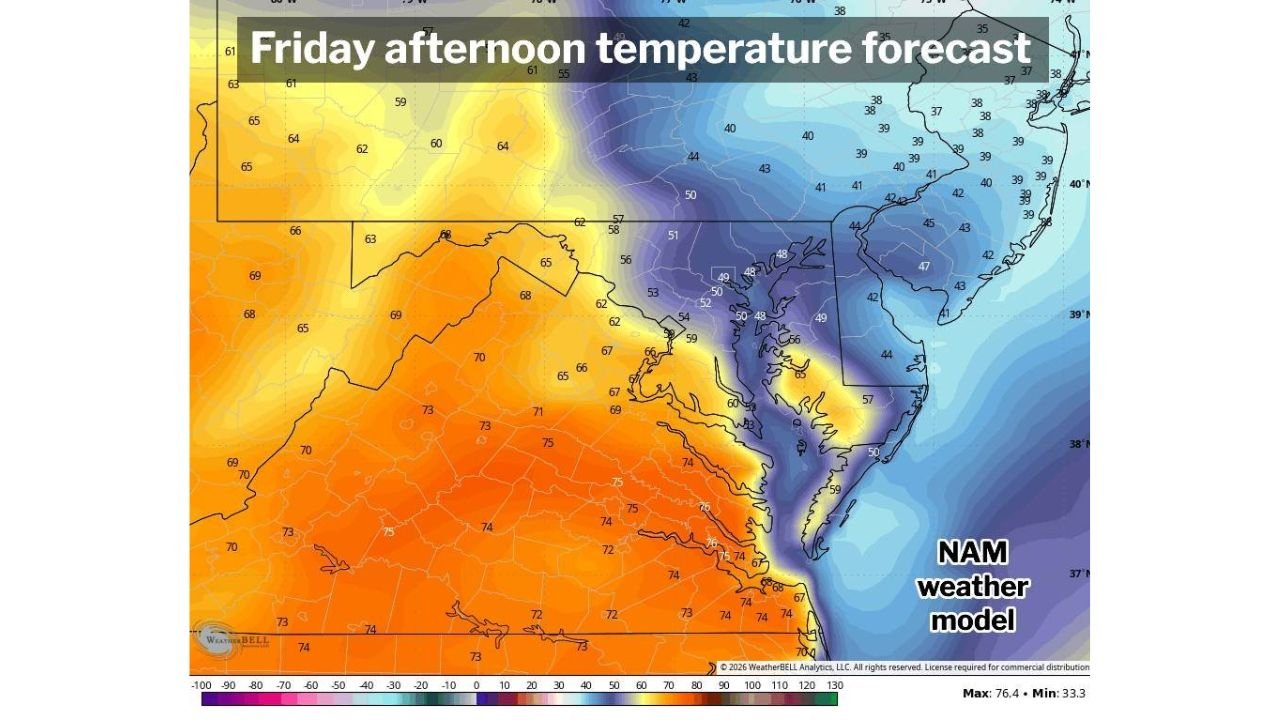
However, the transition to springlike warmth won’t be smooth everywhere. Forecast guidance shows a sharp temperature divide setting up late this week, particularly across Maryland, where cooler air to the northeast may temporarily hold firm.
Big Warmup Building Into the Weekend
A broad warming trend is expected to take hold across the region, with temperatures climbing steadily through Thursday and Friday.
By Saturday, many locations — especially southwest of the Potomac River — could be:
- Well into the 70s
- Potentially near 80 degrees
- Running well above seasonal averages
This marks a notable shift toward early-spring warmth.
Potomac River Temperature Contrast
Forecast maps show a dramatic gradient across Maryland and surrounding states Friday afternoon.
Areas south and west of the Potomac River, including much of:
- Central and southern Virginia
- Southern Maryland
- Portions of west-central Maryland
could reach the upper 60s to mid-70s Friday, with even warmer conditions possible Saturday.
Meanwhile, locations north and east — particularly:
- Northeast Maryland
- Areas closer to Delaware
- Northern portions of the Chesapeake Bay region
may struggle in the 40s and 50s, especially if cloud cover and rain persist.
Why the Forecast Range Is So Wide
Forecasters note that cooler air remains positioned to the northeast. If that cooler air mass:
- Stays entrenched
- Is reinforced by clouds
- Is supported by daytime rain
then temperatures may underperform, particularly across northern and eastern Maryland.
That uncertainty is why there remains a “big range” in projected highs for Thursday and Friday. Some neighborhoods could see 60s or low 70s, while others stay 10–20 degrees cooler only a short drive away.
Saturday: Warm Air Finally Breaks Through
By Saturday, confidence increases that the warm air mass will fully push north.
At that point:
- Most spots across Virginia and Maryland could climb solidly into the 70s
- A few locations may flirt with 80 degrees
- The earlier temperature divide should relax
If sunshine dominates, the region could experience one of its warmest days so far this year.
Bottom Line
A significant warmup is on the way for parts of Virginia and Maryland, with temperatures possibly nearing 80 degrees by Saturday.
Before that happens, though, a stubborn pocket of cooler air across northeast Maryland and areas north of the Potomac River may create sharp temperature differences late this week.
ChicagoMusicGuide.com will continue tracking the evolving temperature outlook as the springlike surge takes shape.