Tampa, Orlando, Sarasota and Fort Myers in Bullseye for Potential Thursday Downpours as Florida GRAF Model Signals High Rain Chances — Lightning a Wildfire Concern
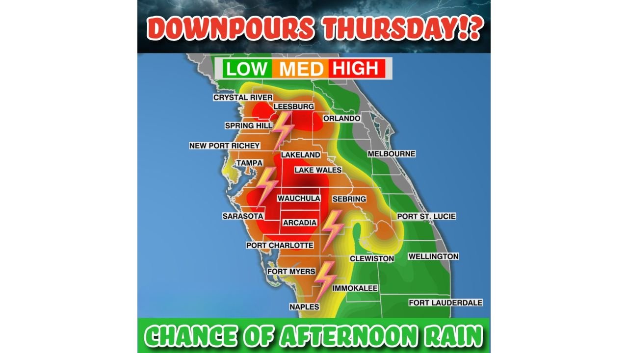
UNITED STATES — A high-resolution weather model is signaling the potential for much-needed rainfall across central and southwest Florida on Thursday afternoon and evening, with several communities showing elevated chances for meaningful downpours.
Forecast guidance from the Hi-Res GRAF model paints broad areas of medium to high rain probabilities, particularly across interior and west-central portions of the peninsula.
High Rain Probabilities From Tampa to Orlando
The highest rain chances appear focused across:
- Tampa
- Spring Hill
- Crystal River
- Leesburg
- Lakeland
- Orlando
- Lake Wales
- Wauchula
- Arcadia
- Sarasota
- Port Charlotte
- Fort Myers
- Naples
- Immokalee
The map highlights large swaths shaded in red and orange — indicating medium to high probabilities of afternoon rainfall.
Interior counties from Lakeland south toward Wauchula and Arcadia appear particularly favored for heavier activity.
Why This Rain Matters
Much of Florida has been dealing with dry ground conditions. Meaningful rainfall would help:
- Reduce wildfire risk
- Improve soil moisture
- Offer temporary drought relief
However, forecasters caution that while the model is aggressive in showing widespread coverage, actual totals may not be as extreme. Even so, if rainfall reaches even half of what is suggested, it would still be beneficial.
Lightning Could Be a Downside
One notable concern is lightning.
Any thunderstorms producing lightning without substantial rainfall reaching the ground could ignite dry vegetation. That risk is especially relevant in:
- Inland southwest Florida
- Areas near Arcadia, Immokalee and Clewiston
- Portions of central Florida
Communities along the east coast, including:
- Melbourne
- Port St. Lucie
- Wellington
- Fort Lauderdale
currently appear to have lower rain probabilities compared to interior and west-coast areas.
Timing: Thursday Afternoon Into Evening
The window for storms is expected to peak:
- During the mid-to-late afternoon
- Continuing into the evening hours
Heating of the day combined with lingering moisture will likely trigger scattered thunderstorms that drift slowly, increasing the potential for localized heavy downpours.
Bottom Line
Thursday could bring beneficial downpours from Tampa and Orlando south through Sarasota, Fort Myers and Naples, with the highest rain chances focused over central and southwest Florida.
While widespread soaking rainfall would be welcome, lightning associated with these storms remains a potential wildfire concern if rain coverage ends up more spotty than projected.
ChicagoMusicGuide.com will continue monitoring updates as Florida’s Thursday rain potential comes into sharper focus.