Enhanced Severe Weather Threat Friday Could Bring Tornadoes, Damaging Winds and Large Hail Across Kansas, Missouri, Oklahoma, Arkansas, Iowa and Illinois
KANSAS CITY, MISSOURI — Meteorologists are closely monitoring an enhanced severe weather setup expected Friday afternoon and evening across the Central Plains into the Mid-Mississippi River Valley, where storms could bring damaging winds, large hail, and possible tornadoes from Oklahoma and Kansas through Missouri, Arkansas, Iowa and potentially Illinois.
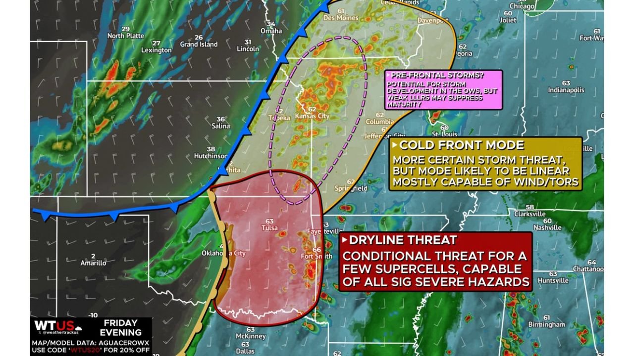
Forecast guidance shows a bi-modal severe weather pattern, meaning storms may develop in multiple zones simultaneously, including along a crashing cold front, a sharpening dryline, and within the open warm sector ahead of the front.
Forecasters say the best chance for organized severe storms will occur near the advancing cold front as it moves southeast through the Plains late Friday afternoon and evening. However, isolated storms may develop earlier ahead of the front, especially across Kansas and Missouri, depending on how much daytime heating occurs.
Cold Front Storm Mode Could Produce Widespread Damaging Winds
The most certain severe weather scenario involves storms developing along the rapidly advancing cold front pushing from Nebraska and Kansas toward Missouri and Iowa.
As the front crashes southeast, storms are expected to organize into a linear squall line, a structure capable of producing widespread damaging wind gusts and occasional embedded tornadoes.
Cities within the projected corridor include:
- Wichita, Kansas
- Kansas City, Missouri
- Columbia and Jefferson City, Missouri
- Des Moines, Iowa
- Springfield, Missouri
- Peoria and areas near Chicago, Illinois
Meteorologists say the linear storm mode will likely dominate, meaning damaging winds may become the primary hazard. However, the storm line could still produce brief tornadoes embedded within the system, particularly in stronger segments.
Pre-Frontal Storm Development Possible Across Kansas and Missouri
Another potential concern involves pre-frontal storms forming ahead of the cold front, especially across eastern Kansas and western Missouri.
Recent high-resolution model guidance suggests pre-frontal convection could develop due to remnant outflow boundaries from previous storms, creating isolated clusters of thunderstorms during the afternoon.
However, forecasters note that weak low-level lapse rates—a measure of atmospheric instability—may prevent these storms from strengthening significantly.
If sufficient surface heating occurs, though, these storms could mature and produce severe weather hazards before the main storm line arrives.
The region around Kansas City, Topeka, and Columbia is currently being monitored for this possibility.
Dryline Threat Across Oklahoma and Arkansas Could Produce Supercells
Farther south, a dryline boundary stretching through Oklahoma and toward Arkansas may provide another zone where severe storms could develop.
This threat is described as highly conditional, meaning only a few storms may form—but if they do, they could become powerful supercells capable of producing all severe weather hazards.
Potential hazards in this southern zone include:
- Large hail
- Damaging wind gusts
- Strong tornadoes
Areas including Tulsa, Oklahoma City, Fort Smith, and northwest Arkansas fall within the zone where storms could develop along or east of the dryline.
However, meteorologists warn that the dryline may not sharpen until the evening, which could limit storm development earlier in the day.
Storm Timing Could Shift the Biggest Threat Into the Evening
Another key factor in this evolving forecast is timing.
If storms along the dryline remain suppressed during the afternoon, they may not fully develop until after sunset when the cold front arrives.
When this happens, storms often transition into a more organized line of thunderstorms, increasing the risk of damaging wind events across a larger area.
Forecasters say the late-day and evening period appears most favorable for severe weather development, particularly from Kansas and Oklahoma through Missouri and into Iowa and Illinois.
If storms develop earlier along the dryline before the cold front arrives, the environment could support significant severe weather including EF2+ tornado potential.
Midwest Cities Including Chicago Could See Storm Impacts
The projected storm corridor stretches northeast from the Plains toward the Midwest, meaning areas farther east could also experience strong thunderstorms later Friday night.
Cities and regions currently within the broader risk zone include:
- Kansas City, Missouri
- Springfield, Missouri
- Des Moines, Iowa
- Tulsa, Oklahoma
- Fayetteville, Arkansas
- Peoria and Chicago, Illinois
While the highest severe risk currently appears across Kansas, Missouri, and Oklahoma, storms moving east could still bring strong winds and heavy rain into parts of Illinois later Friday.
Meteorologists Monitoring Atmospheric Heating and Instability
Forecasters emphasize that surface heating and atmospheric instability will determine how intense storms become.
If temperatures rise enough to strengthen the atmosphere during the afternoon, storm intensity could increase significantly across the Plains and Mid-Mississippi Valley.
On the other hand, if cloud cover limits heating, storms may remain more scattered or weaker until the cold front arrives.
Because of these variables, meteorologists continue analyzing high-resolution forecast models and satellite trends to refine the severe weather outlook.
The evolving setup highlights the complexity of spring storm systems across the Plains and Midwest, where multiple boundaries—such as cold fronts and drylines—can interact to produce dangerous weather conditions.
As Friday’s storm system approaches, residents across Kansas, Missouri, Oklahoma, Arkansas, Iowa, and Illinois are encouraged to stay alert for updated forecasts and possible severe weather alerts.
For continued updates on major storm systems, severe weather threats, and regional weather forecasts, follow the latest coverage at ChicagoMusicGuide.com.